

Research Article
Sinestral Rotation and NNW Shortening of the Ambato Block induced by Cenozoic NE to E-W Transpression, Argentina
1Faculty of Natural Sciences and IML - UNT, National University of Tucuman, Miguel Lillo 205, T4000 San Miguel de Tucumán, Argentina
2CONICET, National Council of Scientific and Technical Research, Argentina
*Corresponding author: Adolfo Antonio Gutierrez, Professor, Faculty of Natural Sciences and IML - UNT National University of Tucuman, Argentina, E-mail: gutierrez.aa@hotmail.com
Received: March 11, 2019 Accepted: August 20, 2019 Published: August 30, 2019
Citation: Gutierrez AA, Mon R, Arnous A, Cisterna CE. Sinestral Rotation and NNW Shortening of the Ambato Block induced by Cenozoic NE to E-W Transpression, Argentina. Int J Earth Sci Geol. 2019; 1(2): 74-85. doi: 10.18689/ijeg-1000109
Copyright: © 2019 The Author(s). This work is licensed under a Creative Commons Attribution 4.0 International License, which permits unrestricted use, distribution, and reproduction in any medium, provided the original work is properly cited.
Abstract
South of 27° S, where the Nazca plate sinks with low angle below the South American plate, the mountain ranges that constitute the Sierras Pampeanas where uplifted by reverse faults, tilted to the east, during the Pliocene. The analysis and interpretation of satellite images and the systematic recording of fracture planes in outcrops of metamorphic basement rocks and Neogene sediments allow us to determine tectonic events that gave the region of the Ambato Block a NE shortening, a sinestral rotation and NNW shortening. As a result of these tectonic events, during the convergence of the Nazca and South American plates, reverse faults, gravitational faults and transcurrent faults were generated, and the division of the Ambato Block into smaller ranges and the development of intramontane basins ocurred. The Las Cañas normal fault, with E-W strike, was generated before the Andean tectonics, using the schistosity planes of the metamorphic basement; it constitutes a step in which the outcrops of the Santa Bárbara Subgroup of the Salta Group end.
Keywords: Neotectonic; Andes; Sierras Pampeanas; Transcurrent faults; Normal faults.
Introduction
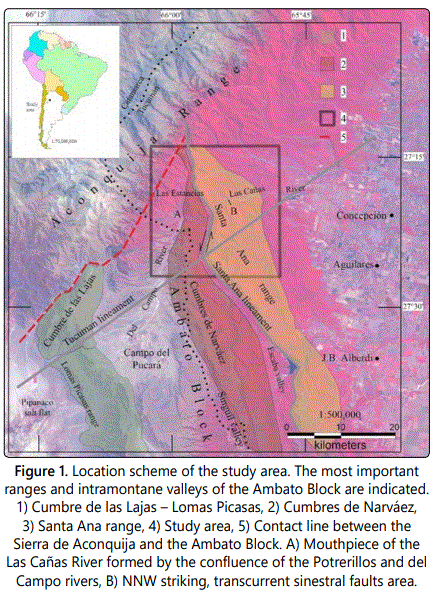
The study area includes from the northern end of the Las Estancias valley to the eastern slope of the Santa Ana range. Las Estancias valley is a tectonic depression that opens to the south to form the Campo del Pucará basin. To the east, the valley limit with the northern end of the Cumbres de Narváez and Santa Ana range and, to the west, with the eastern edge of the Sierra de Aconquija (Figure 1). The region belongs to the morphostructural environment of Sierras Pampeanas Noroccidentales [1], where the Nazca plate sinks at a low angle below the South American plate [2]. The north end of the Ambato Block joins the southeastern edge of the Sierra de Aconquija (Figure 1).
Our work contributes to the knowledge of the outcrops of the Paleogenic and Neogene sedimentary units and determines the occurrence of transpressive NE to E-W tectonic events. The Las Cañas normal fault, with E-W strike, was generated before the Andean tectonics, developed through the schistosity planes of the metamorphic basement. We show concrete evidence of the gravitational faults that dismembered the Ambato Block and that limit the western edges of the ranges, associated with this tectonic event (Figure 1A). The sinestral rotation of the Ambato Block occurred with the NE to E-W transpression of the tectonic event during the convergence of the Nazca and South American plates, after Pliocene time, by reactivation of old structures like Las Cañas fault. This NE shortening and sinestral rotation induced transtensive NNW deformation process that trigger sinestral transcurrent faults with NNW strike (Figure 1B).
Literature Review
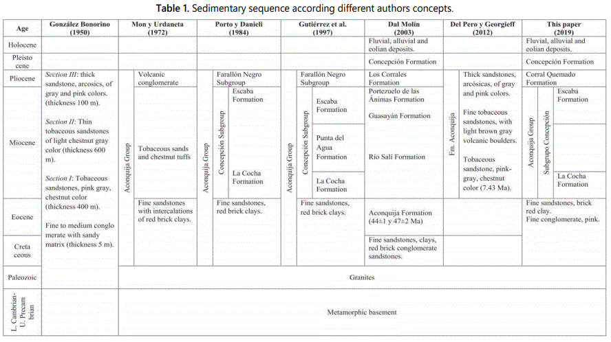
The first investigations were carried out by Rassmuss J and Kittl E [3,4] among others. The metamorphic rocks of the area, of upper Precambrian - Lower Cambrian age, are phyllites, micacites, schists, gneisses, amphibolites and migmatites, which show conditions of low, moderate and high degree of metamorphism [5-7]. In 1952, the first geological and geotechnical studies in the area, carried out by the C.A.P.R.I. company, included the raising of seismic refraction profiles [8]. The sedimentary stratigraphic sequence was studied by González Bonorino [9] in the western area of the Campo del Pucará; later, Niepagen C and Vergel M [10,11], raised derailed profiles in the Las Estancias valley area. Mon R and Urdaneta A [12] called Aconquija Group, the sequence integrated from the base to the roof by 40 m of fine red brick sandstones with intercalations of claystones of the same color, tobaceous sandstones and chestnut tuffs and a very consolidated conglomerate, with well-rounded stones of an desites, basalts, tuffs, shales and granites.
Porto JC and Danieli C [13] divide the Aconquija Group, calling the Concepción Subgroup to the lower sequence and Farallón Negro Subgroup to the upper sequence. These authors include in the Concepción Subgroup the La Cocha Formation (volcaniclastic, pelitic, gray-colored sandstones) in the lower section and the Escaba Formation (siltstone with sandstone intercalations, orange-brown) in the upper section, estimating a partial thickness of 400 m and assigning them a Miocene-Pliocene age. Gutiérrez AA et al [14] study the sedimentary sequence and the structures on the riverbanks of the Cóndor Huasi River, on the western slope of the Cumbres de Narváez. Bossi GE and Gavriloff IJC [15] consider that the lower red brick section of the Aconquija Group would be of Cretaceous age and the upper volcanic conglomerate section would be correlated with the Corral Quemado Formation, of Pliocene age. Radiometric data of tuffs from the outcrops of the Escaba lake area, constituted of whitish tuffs, gray tobaceous sandstones of medium to coarse grain and very fine grain chestnut tuffs, gave K/Ar de 44 ± 1 y 47 ± 2 Ma ages [16]. In the outcrops of the Punta del Agua and Pantanillo rivers the three members of the sedimentary sequence were described by Del Pero MA [17], which reach about 1100 m in thickness, and dated the lower half of the stratigraphic column in 7.43 Ma [18].
The mountain blocks that constitute the Sierras Pampeanas would have been uplifted by reverse faults during the Pliocene [9] and the mountains that make up the Sierra de Aconquija and Cumbres Calchaquíes would have uplifted between 10 Ma and 3 Ma [19,20]. Integrating modeled cooling histories constrained by K-Ar ages of muscovite and biotite, apatite fission track data as well as (U-Th)/He measurement of zircon and apatite, growth of the modern topography began in the Cenozoic during Andean deformation, and the Sierra de Aconquija experienced 10–13 km of vertical rock uplift, ~4–5 km of peak surface uplift, and 6–8 km of exhumation since around 9 Ma [21]. After the uprising of the ranges by reverse faults, the Ambato Block would have experienced normal gravitational faults that dismembered it in smaller mountain ranges and formed intramontane valleys [22-25]. The morphology of the tectonic depression Las Estancias - Campo del Pucará represents an inverted alluvial fan and the morphotectonics of the north end of the Ambato Block evidences tectonic processes of counterclockwise rotation [25-27]. The northern end of the Ambato Block evidences a break, marked by the Tucumán Lineament [23] and by the Las Cañas River, which represent structures oblique to the Andean strike as described by Mon R and Gutiérrez AA [28] in the Subandean system. The Cumbre de las Lajas and the northern ends of the Cumbres de Narváez and Santa Ana range, with NE, north and NNW strike, respectively, contrast sharply with the NW strike of the Lomas Picasas and the southern portion of the Cumbres de Narváez and Santa Ana range (Figure 1). The separation between the Cumbre de las Lajas and the Lomas Picasas range evidences an extensive tectonic process. On the other hand, the zigzag geometry of the northern ends of the Cumbres de Narváez and Santa Ana range show tectonic processes of shortening (Figure 1) [25].
Methodology
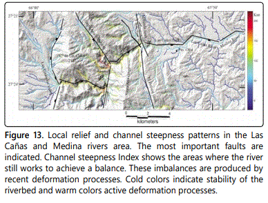
Seven fieldtrips were carried out totaling 35 days of field work. During the fieldworks stratigraphic profiles were made and structural data of sedimentary rocks, fractures in metamorphic rocks and fault measurements were taken, both in outcrops of the ranges and on the Las Cañas riverbed. A total of 468 planes of joints and faults were measured; 51 on both riverbanks of the Las Cañas River mouth, 226 in the Miranda fault area, 139 in a length of 11 km along the Las Cañas River, from the puesto Olea upstream and 52 in the Neogene sediments that outcrop in the El Naranjal and Villa Lola areas. The geological map at 1:50,000 (Figure 2) was drawn from the visual analysis and interpretation of LANDSAT 8 TM image, supported with previous geological map [9] and improved with field data. We know that incising channel systems play a central role in setting relationships among topographic relief, which drew our attention to apply the new methodology to interpret the drainage signature and understand the tectonic behind it [29]. We used DEM (Digital elevation model) with resolution of 12.5 meter, obtained from the Alaska satellite facility [30], to analyze the drainage network using the TopoToolbox program [31,32], processed in Matlab software, to generate channel steepness index. We show the application of a measure of channel gradient normalized for downstream in the drainage area to recognize perturbations channel profiles which can indicate tectonic activity. The fracture data were processed with the GEOrient 9,5 software to determine the most frequent orientations and conjugate pairs from the population [33].
Results
Upper precambrian - lower cambrian
The metamorphic basement of the area is constituted of mass injection gneisses, due to the injection of granitic material that often obliterates the schistosity (Figure 2). It contains as inclusions numerous fragments of banded schist that represent the embedding complex. The fragments included have not been completely digested by the migmatitic injection and in most cases, they retain their original structure (banded). The cleavage of this complex is manifested only in isolation because of the injection of granitic material, so that their discontinuities are welded giving mass character to the whole lithological set. Metamorphic rocks are schists, gneisses and amphibolites that show low, moderate and high conditions of metamorphism. In these outcrops the typical banded structure is manifested, and it gives the name to this entity (Banded Schist), which extends through the central part of the Cumbres Calchaquíes, Sierra de Aconquija and much of the Ancasti range. In the banding alternate micaceous and quartz folias that up to 2 cm thick. This is an oblique tectonic foliation to the original stratification, produced by deformation and tectonic differentiation. On the shales, a second tectonic banding is also recognized, accompanied by folds of 3 to 5 cm wavelength that deform the first tectonic foliation [5,6].
Ordovician
González Bonorino F [9] describes granitic and pegmatitic bodies in the eastern slope of the Cumbres de Narváez and Toselli A et al. [34] the Los Alisos granite that is injecting to the gneisses of the area. Los Alisos granite is composed of bodies with an equigranular to porphyric texture, from pink to gray colors, constituted by plagioclase, microcline, quartz and muscovite with accessories of apatite, biotite, chlorite, zircon, tourmaline and opaque minerals. In the study area, two granite bodies were identified towards the right margin of the Las Cañas River in the Cumbres de Narváez and in the Santa Ana range; also, numerous dykes and pegmatitic veins affect the entire igneous-metamorphic basement (Figure 2). These intrusive bodies, from equigranular to porphyric texture, with pink to gray colors, are constituted by quartz and microcline, sometimes replaced by albite, muscovite and tourmaline; occasionally beryl occurs. In the literature there are no other data on these intrusive bodies, so we tentatively include them with intrusive Ordovician rocks.
Tertiary
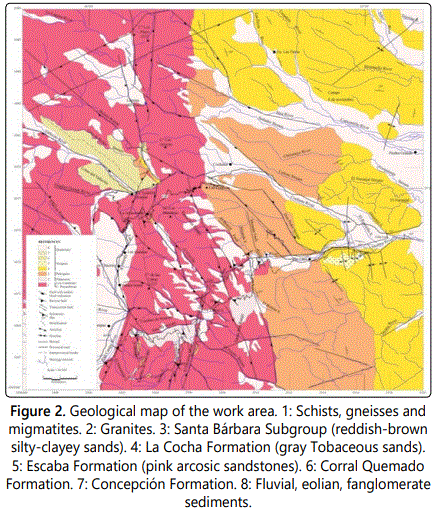
The sedimentary sequence is represented from the base to the top by sandstones and claystones of red brick color, tobaceous sandstones and gray colored sandy tuffs and thick arcosic sandstones of gray and pink colors, superimposed by volcanic conglomerates. From the eastern flank of the Santa Ana range to the east are the best outcrops of sedimentary sequence, folded, with more than 100 m thick. They are arranged on igneous and metamorphic rocks and in some cases are covered by silty-sandy sediments or quaternary conglomerates. The volcanic conglomerates only appear in the northwestern area (Figures 2 and 3).
Paleogene
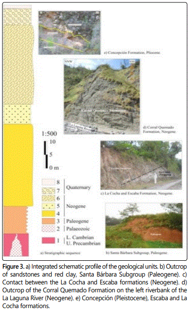
Northwest of the study area, in sectors of the La Laguna River, Casa de Piedra stream and Vallecito River, isolated outcrops of sandstones and red claystones are observed, that tilt predominantly to the west, distributed in an extension of 300 m and not more than 10 m of thick. They are discontinuous outcrops, partially covered by Quaternary sediments. These sandstones have continous gypsum veins and up to one centimeter thick. On the eastern slope of the Santa Ana range, the red sandstones and claystones cover a greater surface, they reach 15 m thick and are tilting to the NE. On the left riverbank of El Bolsón stream, a fine conglomerate approximately 0.50 m thick is lean by discordance over granite rock. The conglomerate is whitish pink, sandy matrix and carbonated cement, with diameter clasts up to 2.5 cm of potash feldspar, plagioclase, quartz, micas, migmatites and granites. Above is a red sandstone 1.0 m thick (Figures 2 and 3b). Based on its characteristics and disposition, we consider that this sequence belongs to the Santa Bárbara Subgroup of the Salta Group. The conglomerate was found in the Campo del Pucará and in the Santa María Valley [14, 43], the sandstones and red claystones in the Los Colorados area, in the Santa María valley and on the western, middle slope of the Cumbres Calchaquíes, over thrusted by metamorphic basement [35].
Neogene
The complete sequence of the Neogene outcrops along the western edge of the Campo del Pucará was described by González Bonorino F [9]. Subsequently, other authors described the sedimentary units in different areas, both from the western edge of the Tucumán basin [13-16] and in the Campo del Pucará and Las Estancias valley [12,14,17,18], assigning different categories and subdivisions (Table 1). We chose to maintain the subdivision of Aconquija Group, Concepción Subgroup, integrated by the La Cocha, Punta del Agua and Escaba formations; however, only the representative sequences of the La Cocha and Escaba formations (Table 1) are presented in our study area.
La Cocha formation: Tobaceous sandstones and sandy tuffs are greenish gray, with important participation of volcanic material, well consolidated; they are found above the red brick sandstones and claystones. In the gray sandstones, conglomeradic layers are intercalated with other tuffaceous layers. On the eastern slope of the Santa Ana range are the best outcrops, which reach about 100 m thick. At the eastern end of the Santa Ana range they are arranged forming anticline and syncline folds of NW and NE strike, very tight, covered by Quaternary conglomerates (Figures 2 and 3c). In the area of the La Laguna River, Casa de Piedra stream and Vallecito River, isolated outcrops of gray tuffaceous sandstone are observed, whose strata slope predominantly towards the west, of very small thicknesses, covered by conglomerates and Quaternary loess sediments. We consider that these sedimentary units correspond to the La Cocha formation [13]. In this sector, the set of gray tuffaceous sandstones and volcanic conglomerates (Corral Quemado Formation) can exceed 50 m in thickness (Figure 2).
Escaba formation: On the slope of the right riverbank of the Las Cañas River, from the puesto Olea to the confluence of the Cochuna River, above the gray tuffaceous sandstones (La Cocha Formation), there is sporadically a light pink, pink sandstone, about 6 m thick, covered by thick Quaternary conglomerates, that we consider represent the formation defined by Porto JC and Danieli C [13] (Figures 2 and 3c).
Corral quemado formation: The volcanic conglomerates of both riverbanks of the La Laguna River and of the right riverbank of the Vallecito River (Figures 2 and 3d), are greenish gray and variable granulometry; are covered by thick mantles of thick quaternary conglomerates. Zonally, within the same outcrop, is common to find parallel bands to the stratification, of fine and uniform conglomerate (clasts of the order of centimeter in diameter). Sometimes, they gradually change into a thick cenoglomerate in which the size of the individuals varies, predominantly the clasts of the order of 5 cm in diameter being able to become much bigger. These are polymictic conglomerates where most of the clasts are frequently of volcanic origin, in addition, these are usually the largest; the rest is constituted by individuals of metamorphic origin and pegmatites. The matrix of the conglomerates is psamitic.
The volcanic conglomerate is well consolidated, with clasts of heterogeneous size and composition, angular to subangular (up to 0.5 to 0.6 m in diameter), presents a sandy, tuff-colored, greenish support matrix. The clasts are predominantly of volcanic origin, some of them show significant surface weatering. Also, they are constituted by rounded clast of pegmatite, schist and granite. On the left riverbank of the La Laguna River the volcanic conglomerates dip 40° to the SE. Outcrops of these conglomerates are also found at the northern end of the Cumbre Las Lajas, outside the study area (Figure 1). These conglomerates have similar characteristics than the conglomerates that are located over the Andalhuala Formation, in the Santa María valley [36].
Quaternary
Pleistocene
Concepción formation: To the east of the puesto Olea, on the slope of the Santa Ana range, there is a small outcrop of thick conglomerates, of gray colors, sub-rounded and angular clasts, of the same composition as the basement, about 4 m thick. This conglomerate is arranged in erosive discordance over the pink sandstones of the Escaba Formation and we consider that they represent to the outcrops described as Concepción Formation of Pleistocene age (Figures 2 and 3e) [16]. The sequence is tilted, the conglomerate is 20°/180° strike, which shows that it was affected by the Andean tectonics.
Holocene
The Holocene sediments are poorly consolidated; but the conglomerates are well consolidated and widely distributed throughout the area. They are constituted by conglomerates with lenticular intercalations of thick reddish and gray sandstones. In general, the clasts are well rounded and cemented by a poorly consolidated sandy matrix. These deposits cover large areas of pedimentation developed in the metamorphic massif. Sometimes they rest on Neogene sediments, on volcanic conglomerates or on metamorphic rocks and they fill a large part of the riverbeds, as detritus flows, when the waters washed the entire sandy matrix of the conglomerate. It is possible to distinguish at least three different conglomerates in terms of clast size, angulosity, color and consistency, which come from the eastern slope of the Sierra de Aconquija (Figure 2). The thickness of conglomerates and Quaternary sediments reach up to 50 m. The riverbed of the La Laguna River was filled by a debris flow composed mostly of basement rocks, of variable size and large blocks which volume is of the cubic meter or greater, river carrying products in exceptional floods. In the El Bolsón, Casa de Piedra and Vallecito rivers, the sediment is composed of large boulders immersed in a psamitic friable and abundant matrix. It is an oligomictic agglomerate because the blocks are fragments of the same rock mica schists. The bed of the Vallecito River is covered by an alluvium that is estimated between 1 m and 3 m thick. This alluvium is constituted by clasts of variable size, among which the blocks predominate (diameter greater than 256 mm) and the blocks which volume exceeds the cubic meter are frequent in the bed. The clasts, practically without exception, are fragments of mica schists. This alluvium of thick granulometry lacks silts and clays. Fluvial debris almost always is aterraced, many times cut by the current channels. They are oligomictic agglomerates, of mica schists. They are predominantly subspherical and show good rounding. They are immersed in a friable and abundant matrix constituted by finer materials, psamitics or psephitic represented by sands of different granulometry and, sometimes, argillaceous materials. The selection of these accumulations is very poor, usually mixing blocks and clasts, from 10-15 cm to more than one meter in diameter. This material is partially or totally covering the other lithological units. In the Yunka Suma area, on the right riverbank of Las Quintas stream, a conglomerate of 30 cm thick, grayish brown, with clasts of variable sizes, support matrix, with intercalations of brown silty banks outcrops. The angular clasts are of granitic and metamorphic composition, up to 0.50 m in diameter. On top of these conglomerates is also a sandy and silty sequence, yellowish brown, friable, from 30 to 40 m thick. It was observed in the channel of the Las Cañas River, in the area of the confluence with the Medinas stream that, in a period of flood of the year 2015, was accumulates more than 2 m thickness of fanglomerates coming from the eastern slope of the Sierra de Aconquija, they are probably the product of erosion and destruction of the moraine deposits.
Structures
In the Andean foreland between 26° and 32° SL, the deformation of the Neogene and lower Quaternary generated a set of reverse faults that uplifted large blocks of Precambrian and Paleozoic crystalline basement, included in the geological province of the Northern Sierras Pampeanas. In the study area, two mountain ranges converge, represented by the Sierra de Aconquija to the north, with NNE strike, and to the south by the Ambato Block, with a NNW general strike, limited by a deformation belt called Tucumán lineament [23]. In addition to the basementʼs own structures, produced mainly by ductile deformation at great depth, a fracture tectonics is shown under more superficial, fragile conditions, which generated a system of joints clearly posterior to the structures of the metamorphic complex. At the western edge of the Ambato Block, in the Las Estancias valley, reverse and normal faults are affecting Quaternary conglomerates and terraces.
The morphostructure of the northern end of the Cumbres de Narvaez and Santa Ana range, describes a particular morphology, in zigzag, marked by the strike of the structures and the minor mountain ranges that compose them (Figures 1 and 2). Las Cañas fault cuts the northern end of the Cumbres de Narvaez and Santa Ana range. The Santa Ana lineament, represented by the El Durazno and Clavillo streams and La Laguna river, marks the western edge of the Santa Ana range; it appears broken, taking NE and NW strikes, forming intramontane valleys. To the east, the El Bolsón fault marks the boundary of the outcrops of the Paleogene red sandstones. On this fault, south of the Las Cañas River, we have found a fine conglomerate discordant on granitic rock, and on it, the red sandstones of the Paleogene (Figures 1 and 2). The attitude of the El Bolsón fault plane, in the fault gap zone, is 78°/240° and 70°/085° (Figure 2).
On the slope of the Santa Ana mountain range, from the puesto Olea to the east, the sedimentary sequence is folded. There are anticlines and synclines with NE and NW strike, to the south and north of the Las Cañas fault, respectively (Figure 2).
Las Canas fault
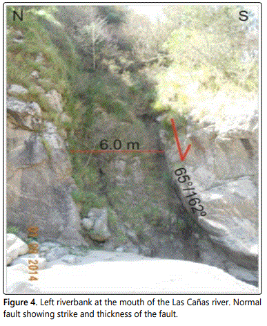
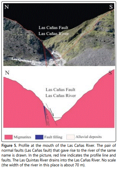
The Las Cañas River was formed by the Las Cañas normal fault that dismembered the metamorphic basement. The upper course of the Las Cañas River drains eastward, but the Santa Ana lineament twists its course towards the NNE, then shifts to the east at the confluence with the Clavillo stream. The Miranda fault gives to the Las Cañas River again sharp changes to the south and north, in a stretch of about 700 m, and then continues dripping to the east (Figure 2). Las Cañas fault is a system of normal faults with southeast dipping. At the mouth of the Las Cañas River, on the left riverbank (Figure 1A), there is a wide groove of erosion that corresponds to a normal fault zone, with a 65°/162° strike (Figures 2 and 4). The width of the tectonized and brecciated zone over the Las Cañas River is 6 meters and is limited by parallel joint planes with 75°/162° strike (the northern wall) and 60°/162° strike (the southern wall). The fault gap is made up of highly fractured blocks of rock, separated by cracking planes that have friction mirrors and clay fillings. Towards the south wall of the fault is a gap zone (granulation and soap) of 0.50 m thick (Figure 4). However, the width of the Las Cañas River in this area is about 70 m, so there would be a larger normal fault, to the south, parallel to the previous one, through which the river drains and which is covered by the alluvial deposits (Figure 5).
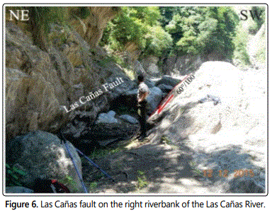
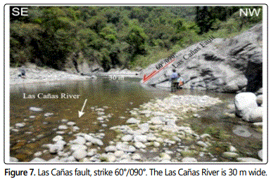
From the puesto Olea (Figure 2) to the west, we crossed the Las Cañas River bed for 11 km, measuring fractures and the Las Cañas fault planes. In the area indicated with B, in figure 1, at the confluence of the Miranda stream with the Las Cañas River, we have found a similar situation to that described at the mouth of the Las Cañas River (Figure 1A). The normal fault is observed, but on the right riverbank of the river, with strike 60°/100° and, the width of the fault is about 6 m (Figure 6). To the north of the fault, to the left riverbank of the river, the channel is 20 m wide. That is, they are two normal faults (as in the previous case), one 6 m wide and another 20 m wide. Throughout this section it was possible to measure the plane of the Las Cañas fault in several places, carved following the schistosity planes of the metamorphic basement (60°/090°, 75°/100°, 30°/150°, 40°/148°, 35°/117°, 30°/098°, 35°/125°, 70°/135°) (Figure 7); in all cases, the planes of the Las Cañas fault are dipping east and southeast.
Narváez fault
The Ambato Block, built on its western edge by a reverse fault with an eastern dip at the end of the Neogene [9], is made up of a mosaic of smaller mountain ranges, separated by intramontane basins and narrow valleys, such as the Cumbres de Narváez, Santa Ana range and Las Estancias valley (Figure 2). The erosion surfaces carved in all the mountain ranges tilt towards the east and their western flanks are limited by normal gravitational faults, of NNW strike, dipping to the west, generated after the reverse faulting, [22-25] like Narváez fault.
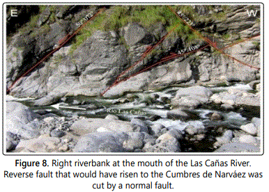
The Narváez fault marks the western edge of the Cumbres de Narváez; to the west, the Las Estancias valley, the Campo del Pucará and the Sínguil valley extend (Figure 1). The western edge of the Cumbres de Narváez is raised, its peneplain slope towards the east, marked this morphology by the Narváez fault. The western edge of the Cumbres de Narvaez is limited by two faults. First, reverse faults dipping toward the east were generated [9], who produced the uplift of the Cumbres de Narváez (Figure 8).
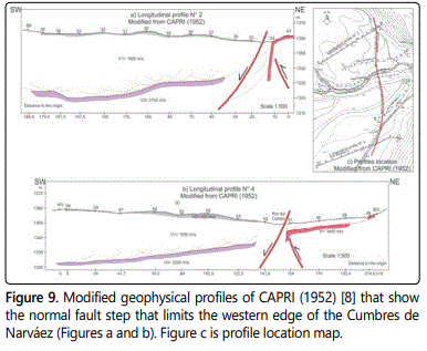
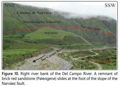
Subsequently, a gravitational fault dipping to the west originated the Las Estancias and the Sínguil valleys. This fracturing scheme is observed in the right riverbank, in the embouchure of the Las Cañas River, the reverse fault (45°/108°) is cut by a normal fault (45°/223°) (Figure 8). The geophysical studies conducted by the CAPRI company in 1952 [8]. In the area of the Las Cañas River mouth (indicated with A in figure 1), determined in two seismic profiles the step of the Narváez fault, with normal displacement and dipping to the west (Figure 9). The reverse fault drawn in the seismic profile was interpreted based on the structures outcrop shown at the right riverbank of the Las Cañas River (Figure 8). This fault limits the western edge of the Cumbres de Narváez, with a step of about 30 m in this area (Figure 9). The normal fault is also observed on the right riverbank of the Del Campo River, in the vicinity of its confluence with the Las Cañas River, where red brick sandstones (Paleogene) are sliding at the foot of the slope of the fault (Figure 10).
Miranda fault
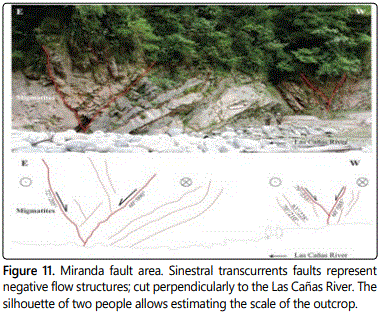
Miranda fault is the most representative of a sinestral fault system, which develops in a fault zone of about 700 m in length (Figure 2). This system faults are marking the limit of the outcrops of the Paleogene red sediments in the eastern slope of the Santa Ana range, mainly defined this limit by the El Bolsón fault, of NNW strike and about 11 km of length (Figure 2).
The Miranda fault system produces sharp breaks in the channel of the Las Cañas River, diverting it to the south and to the north. Are faults of short development, the Miranda fault is about 3.5 km long (Figure 2).
Preferential strike fault planes NNW-SSE were identified (72°/205°, 60°/085°, 60°/090°, 63°/228°, 70°/210°, 79°/233°, 75°/054°, 82°/246°, 82°/080°) and other less frequent NE-SW (78°/150°, 85°/345°). The main faults are represented by the 60°/085°, 75°/054°, 82°/080°, 60°/090° planes, which define a transtensive stress system, with sinestral horizontal displacement and normal vertical component (Figure 11). Practically no kinematic fault indicators were found; in one of them (72°/205°), a Riedel plane (7°/230°) was measured.
This whole faults system describes an upward concave geometry, called “tulip structure”, a structural model known in the literature, generated by transcurrent faults with normal vertical component [37]. These fault zones can measure in some cases more than 5.0 m wide each (Figure 11).
Fractures
Fractures are discontinuity surfaces that divide rocks and minerals into blocks in nature. They can be generated during fragile, contractional or extensional deformation, as a result of efforts that have exceeded breakup resistance [38]. When the fractures do not show or have a negligible parallel displacement along the fracture plane, they are classified as joints. Fracture patterns, represented by two or more sets of joints, present in an outcrop of rock, intersecting at more or less constant angles and similar geometries, respond to a local state of effort [39,40]. From the relationship between fracturing and faulting, it is possible to define the directions of the main stresses and loads at the moment of their formation. Also, knowing the orientation of the fault plane and the fractures associated with it, one can deduce the direction of motion of the fault [40]. The horizontal shear zones usually have extensive or compressive components, in which case they are called transtension and transpression zones, respectively. In transpression secondary structures tend to orthogonality, whereas in transtension they tend to be more parallel to the shear zone [41]. Besides, in the transtension, structures with concave geometry are generated upwards, called “structures in tulip” [37], and, in the transpression, structures with convex geometry are formed upwards, called “structures in palm tree” [42].
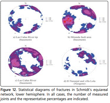
On both riverbanks of the Las Cañas River mouth, 51 planes of joints and faults were measured (Figure 1A). The average principal strike of these planes is 75°/035°, resulting in four major fracture planes (48°/045°, 83°/221°, 84°/174°, 77°/322°) (Figure 12a).
In the Miranda fault area, in a length of 700 m, 226 planes of joints and faults were measured, on both riverbanks of the Las Cañas River. The average principal strike of the data population is 79°/066° and four resulting planes were obtained (57°/082°, 60°/232°, 84°/172°, 70°/320°) (Figure 12b).
In a length of 11 km along the Las Cañas River, from the puesto Olea upstream, 139 joints and faults planes were measured (Figure 2). In the whole route, only metamorphic rocks outcrop, always covered by Quaternary rocks or by a regolith of considerable thickness, product of the weathering of these. From these planes, the average principal strike is 73°/072° and two main planes were extracted (70°/227° and 51°/078°) (Figure 12c).
In the gray tobaceous sandstones (La Cocha Formation) that outcrop in the El Naranjal and Villa Lola areas, at the base of the eastern slope of the Santa Ana range, 52 structural joints planes were measured. The average principal strike of these planes is 72°/207° and the data population represents two main structural planes (59°/194° and 79°/344°) (Figure 12d).
Active deformation processes
For the purpose of determining active tectonic processes associated with the main structures in the Ambato Block, both of E-W and NNW, and, considering an area of difficult access and scarce outcrops, we resorted to the search for regional deformation indicators. In this sense we carry out an analysis of the incision of the drainage network and its relationship with the topography, to detect sectors where the drainage has not reached equilibrium, due to active tectonic deformation processes, with which they are associated. You can see the close relationship between the warm colors in the drainage network with the location of the most important faults. The zone with recent deformation processes is found from the Miranda fault to the head of the Las Cañas river, mainly associated with the Santa Ana lineament, Miranda fault and Las Cañas fault (Figure 13). Another indicator of active tectonic deformation, at mesoscale, are the Pleistocene conglomerates of the Concepción Formation, arranged at 20°/180°, in erosive discordance on the Escaba Formation (Figure 3e).
Discussion
The stratigraphic sequence is integrated by metamorphic rocks assigned in the literature to the Upper Precambrian - Lower Cambrian, intruded by Paleozoic granite rocks, on which lay out in discordance a Paleogene - Neogene sequence (Figures 2 and 3, Table 1). The Paleogene sequence, correlated with the Santa Bárbara Subgroup of the Salta Group, outcrop to the upper - middle slope of the Santa Ana range. In the northwestern area there are small outcrops (Figure 2). The fine conglomerate in discordance on granitic rocks and the red arcilitic sandstones, were found in other areas such as Condor Huasi in the Campo del Pucará, El Remate in the Amaicha valley, in Los Colorados in the Santa María valley and in the middle western slope of the Cumbres Calchaquíes [14, 15, 35, 43].
For the Neogene sequence we prefer to keep the denomination and subdivisions of Mon R et al., Porto JC et al. and Gutiérrez AA et al. [12-14] (Table 1). In the study area, only La Cocha and Escaba formations are represented; of the Punta del Agua Formation, composed of fine tobaceous sandstones, with light brown gray volcanic rocks, no outcrops were found. La Cocha Formation has extensive development in the eastern area, in the slope of the Santa Ana range. In the northwestern area, on the riverbanks of the Casa de Piedra stream and La Laguna River, the outcrops are very small (Figure 2). The arcosic, gray and pink sandstones that represent the Escaba Formation apear in a small outcrop on the slope of the Santa Ana range (Figure 2). In the area of Esquina Grande (Figure 2), limited by the Esquina Grande and La Laguna rivers, there is an outcrop of thick volcanic conglomerates, lay out on the remains of the sedimentary units of the La Cocha and Escaba formations. Given the characteristics of these conglomerates, we adopted the considerations of Bossi GE and Gavriloff IJC [15] and correlated them with the Corral Quemado Formation, of Pliocene age. On the slope of the Sierra de Santa Ana, on the right riverbank of the Las Cañas River, outcrop rest of a thick conglomerate, arranged in erosive discordance on the Escaba Formation, whose characteristics correspond to the conglomerates described by Dal Molin C et al. [16] as Concepción Formation, of Pleistocene age (Figure 2). The Holocene deposits are constituted by layers of diverse conglomerates of gray and brown colors, with angular or rounded clast of different sizes, and wind sediments (Figure 2).
The Las Cañas fault is born at the confluence of the Potrero, Del Campo and Las Quintas rivers, in the Las Estancias valley, and extends for 24 km to the foot of the eastern slope of the Santa Ana range (Figures 1 and 2). It is a sinuous fault, where the Las Cañas River dreins, which in some cases reaches 180 meters wide. The first section of the river, crosses the northern end of the Cumbre de Narvaez with EW strike, up to the Santa Ana lineament. In the Santa Ana lineament it turns to the north and, from the Clavillo stream it crosses the northern end of the Santa Ana range with ENE strike (Figures 1 and 2). The Las Cañas fault also has short breaks, which divert the river to the north and to the south, in the area of the Miranda fault (Figure 2). The Las Cañas fault marks a sudden change in the orientation of the ranges; to the south of the fault the mountain ranges strike NNE and, to the north, NNW (Figure 1). It is a normal fault, which dip to the SE, transverse to the Andean strike, and was formed through the schistosity planes of the metamorphic basement. This structure is prior to the Andean tectonics, is a transversal structure that interrupts the deposits of the Cretaceous rift. In this case allowed the deposition of the upper layers of the sedimentary Grupo Salta sequence (the Santa Barbara Subgroup) which disappear towards the south; as the transverse structures described by Mon R and Gutiérrez AA [28] in the Subandean system.
After the general uplift of the mountain ranges due to reverse faults with dip to the east, towards the end of the Tertiary, gravitational and rotational tectonic episodes occurred that divided the Ambato Block and tilted the smaller mountain blocks. The records of the gravitational and rotational events of the Ambato Block were printed mainly in the tectonic morphology of the region (Figure 1).
The gravitational events are represented by normal faults with NNW-SSE strike and west dipping and are those that trigger the division of the Ambato Block into smaller mountain ranges and gave rise to the intramontane valleys of Sínguil, Las Estancias, Campo del Pucará, etc. (Figures 1,8-10).
The mountain ranges located to the west of the faults are blocks slid with respect to the mountain ranges located to the east; all of them have flat erosion surface to the east (Figure 1) [22-44]. The Narváez fault is representative of this whole system of normal gravitational faults that divided the Ambato Block into smaller ranges and formed intramontane valleys. This fault evidences an initial reverse behavior, with an eastward dip as postulated by González Bonorino F [9] and also evidence a normal behavior, dipping to the west (Figures 8-10) [22-44].
The tectonic morphology and the geometry of the regional structures of the Ambato Block evidence the rotational events that affected it (Figures 1 and 2). The best evidences generated by the rotational events are: a) wedge structures where small lagoons were formed [25], b) to the northeastern of the Santa Ana range, the minor ranges are zigzagged due to the anticlockwise rotation and a NNW shortening (Figure 1), c) in the northwestern area of the Ambato Block, the Cumbre de Las Lajas and Lomas Picasas range are spaced and with different strikes, evidencing that they were separated by a sinestral rotation and extensive deformation (Figure 1) [25-27], d) The Santa Ana lineament would have had a sinestral pattern with a normal component towards the west; the normal component of the lineament caused the landslide to the west of the Cumbres de Narváez and the horizontal displacement produced the breakage of the Las Cañas fault and the sudden change in the orientation of the Las Cañas river towards the north, at the end of the Tertiary (Figures 1 and 2), e) The Tucumán lineament and the Las Cañas fault marks the break generated by the sinestral rotation, to the north of them ranges are NNE and NNW strike, but to the south, they are, in general, NW strike (Figures 1 and 2), f) The sinestral rotation of the Ambato Block, accompanied by a shortening at its NE end and by extension at the NW end (Figure 1), also has records in the outcroppings of the rocks. The Miranda fault characterizes an area of 700 meter long transcurrents fault that generated sharp breaks in the Las Cañas fault, diverting the Las Cañas River bed to the south and northwards in that stretch (Figure 2). The Miranda fault has sinestral horizontal displacement and normal vertical component and owes its origin to the sinestral rotation of the Ambato Block that produced in this sector a shortening with NNW strike (Figure 11).
With the statistical analysis of the fractures the fields of stress were obtained [39]. In the mouths of the Las Cañas River, Miranda fault and Las Cañas River bed, where the fractures and faults were measured in rocks of the metamorphic basement, the average strike of the fractures is NW with dip to the NE (75°/035°, 79°/066° and 73°/072°); However, the fractures measured in Neogenic sedimentary rocks (villa Lola and El Naranjal) have a medium NW strike with a SW dip (72°/207°) (Figure 14).
In the areas of the mouth of the Las Cañas River and Miranda fault, four conjugated planes of fracture were determined (Figures 14a and 14b) and in the areas of Las Cañas River and Villa Lola - El Naranjal only two conjugated planes of fracture (Figures 14c and 14d). From the geometry of these conjugated planes, the occurrence of two main deformation events is interpreted. For the first, a NE transpression determined with the data measured in metamorphic basement rocks in the mouths of the Las Cañas river and Miranda fault (Figures 14a and 14b). While with the data measured in the Neogenic rocks an orientation of transpression E-W is obtained, for the same event.
This event of shortening deformation NE to E-W is associated with Andean tectonic and is evidenced by the data measured in the Neogenic sedimentary rocks in Villa Lola and El Naranjal and by the folds that affect these sedimentary units (Figures 2 and 14d). The fact that it is affecting Neogenic sedimentary rocks indicates that the forces acted after the deposition of this sequence, reactivating previous fracture planes, with similar geometries. It would be responsible for the general uprising of the Sierras Pampeanas due to reverse faults during the Andean tectonics, related to the convergence of the Nazca and South American plates.
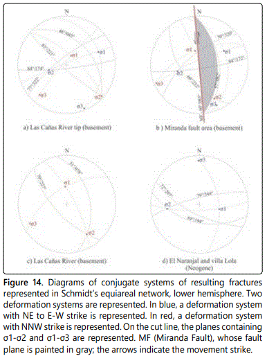
The average NW strike of all fractures measured, in the four areas (Figure 12), gives us an indication that they respond to a deformation in that direction, concomitant with the Andean tectonic, during the Nazca and South American plates convergence. The conjugate fractures with the NW strike and the sinestral faults with NNW strikes, represented by the Miranda fault and the Santa Ana lineament, where produced by a transtensive tectonic stress, with the same strike (Figure 14). This tectonic episode produced the zigzag arrangement of the northern end of the Cumbres de Narváez and Santa Ana range and the break and displacement to the north and south of the Las Cañas fault (Figures 1, 2 and 11). This NW shortening is related to Andean tectonic, that provoked the sinestral rotation of the Ambato Block and is likely to be responsible for the gravitational faults that divided it, such as the Narváez fault (Figures 8 and 9). Although the data obtained in the outcrops of the La Cocha Formation do not present conjugated planes, the average strike of the population of fracture data is NW, associated to it (Figure 14). For the Subandean system, Mon R and Gutiérrez AA [28] postulated that the Andean tectonics with E-W strike reactivated NE structures of the Cretaceous Rift, printing them a horizontal displacement that produced rotational movements, such as the one that takes place in the Ambato Block.
Conclusion
The red layers of the Santa Bárbara Subgroup of the Salta Group (Paleogene) lean on unconformity on an igneousmetamorphic basement. The Neogene is represented by the Aconquija Group, composed of the gray tuffaceous sandstones of the La Cocha Formation and the pink archosic sandstones of the Escaba Formation. The sequence ends with volcanic conglomerates of the Corral Quemado Formation. The Quaternary is represented by conglomerates of the Concepción Formation (Pleistocene) covered by conglomerates and loesoid sediments (Holocene).
The Las Cañas normal fault, constituting a lateral ramp against which the sediments of the Santa Bárbara Subgroup of the Salta Group end. This fault facilitated the sinestral rotation of the Ambato Block during the Andean tectonics, product of the plates convergence.
Two deformation events are recorded, with NE to E-W strike and NW strike, both related with the Andean tectonic during the convergence of the Nazca and South American plates. The first event produced a shortening E-W, the uprising of the ranges by reverse faults dipping to the east and the folding of the sedimentary sequence. This tectonic event affected previous structures, transverse to the Andean strike, as the Las Cañas fault, reactivating them and inducing a sinestral rotational movement to the Ambato Block, facilitating the development of gravitational faults with west dip. The second deformation event was triggered by the first one event during the rotation of the Ambato Block. It provoked a NW transtension at the NE end of the Ambato Block, generating transcurrents fault with NW strike.
The deformation processes are active. The result of this transpressive-transtensive deformation event associated with the convergence of the plates is: a) the uprising of the Ambato Block due to reverse fault with east dip, b) the sinestral rotation of the Ambato Block, c) the contraction of the NE end of the Ambato Block and the extension at its NW end, d) the origin of the gravitational faults such as the Narváez fault, e) the division of the Ambato block due to gravitational landslides to the west, f) the formation of intramontane basins by gravitational landslides, g) the zigzag geometry of the ranges that make up the Ambato Block, h) the origin of the faults and lineaments with NNW strike and with left lateral displacement (Miranda fault, Santa Ana lineament), i) structures with tulip geometry formed by normal strike-slip faults and j) rotation of the axes of the sedimentary sequence folds.
Acknowledgments
We express our acknowledgment to the National University of Tucumán and we appreciate suggestions and corrections of the reviewer.
References
- Caminos R. Sierras Pampeanas Noroccidentales de Salta, Tucumán, Catamarca, La Rioja y San Juan. II Simposio de Geología Regional Argentina. Academia Nacional de Ciencias de Córdoba. 1979; .1: 225-291.
- Isacks B. Uplift of the central Andean plateau and bending of the Bolivian orocline. Journal of Geophysical Research. 1988; 93: 3211-3231. doi: 10.1029/JB093iB04p03211
- Cisterna CE, Mon R, Mena R. Internal structure of the migmatitic strip of the crystalline nucleus of the northern Pampas of the Argentine Northwest. Magazine of the Argentine Geological Association. 2010; 66(1): 66-79.
- Cisterna CE, Aldonate MD, Rosales Daneri J, Günter C, Gutiérrez AA. Migmatites from the Las Cañas river ravine, Aconquija mountain range, northwestern Argentina: chemical characteristics. congresses and scientific meetings, National University of Tucumán. 2017: 32-37.
- Cisterna CE, Altenberger U, Mon R, Günter C, Gutiérrez AA. The metamorphic basement of the southern Sierra de Aconquija, Eastern Sierras Pampeanas: Provenance and tectonic setting of a Neoproterozoic back-arc basin. Journal of South American Earth Sciences. 2018; 82: 292-310. doi: 10.1016/j.jsames.2017.09.028
- González Bonorino F. Descripción geológica de la Hoja 13e, Villa Alberdi, provincia de Tucumán. Argentina. National Mining Directorate. Bulletin no. 74. 1950.
- Bossi GE, Gavriloff IJC. Terciario, Estratigrafía, Bioestratigrafía y Paleogeografía. 2nd edition. In: Gianfrancisco M, Puchulu ME, Durango de Cabrera J, Acceñolaza G (eds). Geología de Tucumán. Colegio de Graduados en Ciencias Geológicas de Tucumán. 1998: 87-109.
- Jordan TE, Alonso RN. Cenozoic stratigraphy and basin tectonics of the Andes Mountains, 20°-28° south latitude. American Association of Petroleum Geologists Bulletin. 1987; 71(1): 49-64.
- Kleinert K, Strecker MR. Climate Change in response to orographic barrier uplift: Paleosol and stable isotope evidence from the late Neogene Santa María basin, northwestern Argentina. Geological Society of America Bulletin. 2001; 113(6): 728-742. doi: 10.1130/0016-7606(2001)113<0728:CCIRTO>2.0.CO;2
- Löbens S, Sobel ER, Bense FA, Klaus Wemmer K, Dunkl I, Siegesmund S. Refined exhumation history of the northern Sierras Pampeanas, Argentina. Tectonics. 2013; 32(3): 453–472. doi: 10.1002/tect.20038
- Gutiérrez AA. Tectonic Geomorphology of the Ambato Block (Northwestern Pampeanas Mountain Ranges, Argentina). 4th International Symposium on Andean Geodynamics, Universitat Göttingen, Germany. 1999: 4.
- Gutiérrez AA, Mon R. Mega-geomorphology of Tafi del Valle-Aconquija, Tucumán. Journal of the Argentine Geological Association. 2004; 59(2): 303-311.
- Gutiérrez AA, Mon R. Kinematic macroindicators in the Ambato Block, provinces of Tucumán and Catamarca. Journal of the Argentine Geological Association. 2008; 63(1): 24-28.
- Mon R, Gutiérrez AA. Estructura del extremo sur del sistema Subandino (provincias de Salta, Santiago del Estero y Tucumán). Revista de la Asociación Geológica Argentina. 2007; 62(1): 62-68.
- Kirby E, Whipple KX. Expression of active tectonics in erosional landscapes. Journal of Structural Geology. 2012; 44: 54-75.
- Alaska Satellite Facility. Dataset: JAXA/METI ALOS-1 PALSAR ALOS 10.2.2011 6ASF DAAC. 2016.
- Schwanghart W, Kuhn NJ. TopoToolbox, a set of Matlab functions for topographic analysis. Environment Model Software. 2010; 25(6): 770-781. doi: 10.1016/j.envsoft.2009.12.002
- Schwanghart W, Scherler D. TopoToolbox 2 e MATLAB-based software for topographic analysis and modeling in Earth surface sciences. Earth Surface Dynamics. 2014; 2(1):1-7.
- Gutiérrez AA, Mon R. Cuencas Cenozoicas contraccionales en los valles Ampujaco, Santa María y Río Nío, Argentina. XX Congreso Geológico Argentino,Simposio 12 (tectónica de los Andes Argentino-Chilenos). 2017: 132-139.
- Naylor MA, Mandl G, Sijpesteinjn CHK. Fault geometries in basement-induced wrench faulting under different initial stress states. Journal of Structural Geology. 1986; 8(7): 737-752. doi: 10.1016/0191-8141(86)90022-2
- Anderson EM. The dynamics of faulting and dike formation with application to Britain. Oliver and Boyd, 2nd Edition, Edinburgh. 1951: 206.
- Nelson RA. Geologic Analysis of Naturally Fractured Reservoirs. Elsevier Inc., ISBN 978-0-88415-317-7. 2001: 352.
- Mon R, Gutiérrez AA, Sábat F, Iaffa D. A Miocene Continental Basin associated with the back thrusting of the Eastern Sierras Pampeanas in the Santa Maria Valley, Northwestern Argentina. Italian Journal of Geoscience (Boll Soc Geol It). 2012; 131(1): 123-135. doi: 10.3301/IJG.2011.27
