

Research Article
The Geoheritage of the Paraiba State South Coast, Brazil
Doctorate in Physical Geography, Department of Geography, University of Coimbra, Portugal
*Corresponding author: Luciano Schaefer Pereira, PhD researcher, Department of Geography, University of Coimbra, Portugal, E-mail: lschaefer2@gmail.com
Received: January 19, 2019 Accepted: January 30, 2019 Published: February 8, 2019
Citation: Pereira LS. The Geoheritage of the Paraiba State South Coast, Brazil. Int J Earth Sci Geol. 2019; 1(1): 51-58. doi: 10.18689/ijeg-1000106
Copyright: © 2019 The Author(s). This work is licensed under a Creative Commons Attribution 4.0 International License, which permits unrestricted use, distribution, and reproduction in any medium, provided the original work is properly cited.
Abstract
The objective of this paper is to present a view of the geoheritage of the Paraiba state south coast, northern Brazil, in order to insert potential sites in coastal geo touristic routes. For this, a mapping of this geoheritage was carried out through the inventory of sites with relevant value. This coast is part of a sedimentary basin that developed on a failed crystalline basement, whose Plio-Pleistocene reactivation resulted in a stepped substrate, and the terrain has coastal geo touristic potential from the point of view of its geoheritage. It was necessary a detailed study of the geoscientific literature of the area, besides a detailed field work, whose look about the physical substrate reflected the importance of this as a heritage element of space. The relief was fragmented into three major morpho sculptural units: coastal plains and tablelands, limited by the slopes, all with their potential sites, developed at various scales and presented herein. Coqueirinho Canyon, Tambaba Beach, Coqueirinho tombolo, the Coqueirinho cones of dejection and the Coqueirinho High Structural were identified as sites. It is therefore pertinent to interconnect this heritage to tourism in the area, so that more motivation arouses the interest of tourists, now turned to the bias of the lithosphere and hydrosphere.
Keywords: Geoheritage; South Coast; Paraiba; Coastal Geotourism.
Introduction
The theme about Natural Heritage is relatively new in Geosciences and there is no unanimity in its definition and characterization. Since the United Nations Conference on the Human Environment, held in June 1972 in Stockholm, environmental problems began to be discussed on an enlarged scale and entered characters that had hitherto been seconded to this discussion agenda.
Thus, in October and November of the same year in Paris, the theme of environmentalism was inserted in the heritage view of space, through the Convention for the Protection of World Cultural and Natural Heritage, under the aegis of UNESCO, where aspects of nature and human-cultural were separated, at least in practice, since it is known that the recognition and protection of a national culture takes place through the “integration of natural elements and their processes with human actions, due to their identity, sensibility and meaning (religious, mythical, historical, symbolic, affective, among others)” [1] established between human beings and nature.
Geoheritage corresponds to the abiotic portion of the Natural Heritage, and can be subdivided into Geological, Geomorphological, Pedological and Hydrological Heritage [2]. Thus, in this work, it was dissociated from the geological heritage, which we consider to correspond to complementary but distinct concepts, both of which are framed in the biotic natural heritage, together with the elements of the hydrological and pedagogical heritage. The term ‘site’ was introduced in Geosciences by Panizza [3], consisting of a portion of geoheritage that has a particular importance for the knowledge of Earth's evolution, climate and life history [3,4], thus possessing assigned values that give it a inheritance meaning as well the possibility of being inserted into a patrimonialization context. It may be a geosite, geomorphosite, hydrosite or pedosite, depending on the patrimonial asset in question.
In a broader view, these values can be scientific, aesthetic, cultural, ecological and/or economic [5,6]. In addition, the identification, classification, evaluation, mapping, protection and promotion of this type of heritage adds an value to tourism activities in the geotourism area, through the interaction between the cultural and natural aspects of the landscape [7]. The area of this paper, which extends from the mouth of the Gramame River to the mouth of the Abiaí River, has an extremely interesting geodiversity that interweaves fluvial, marine and fluvio-marine elements, based on a sedimentary basin, considering, in the scope of this work, its geological and geomorphological aspects.
Thus, when human perception values geological materials (rocky substratum and its elements-textures, structures, minerals, minerals and fossils) with their geological features (folds, faults, joints and breccias), as well as the set of landforms (and correlative deposits) with scientific, pedagogical, cultural or aesthetic interest, we have the definition of geoheritage [3,8], which, by its meaning, deserves to be studied, preserved and valued.
The objective of this work is to present a view of the geoheritage of the south coast of Paraiba state, considering that there are practically no works with this scope in the area [9]. The production of these information, taken to a wide range of researchers, scientists, students and tourists, among others, is an important piece for the construction of a culture that is able to understand that the region in which we live is much more complex than the our ancestors and that geo patrimony plays an important role in understanding this complexity.
Materials and Methods
The present work involves three sequential phases. They are:
1. Bibliographical reference: In this phase, all scientific production involving historical, geomorphological and geological studies of the area was analyzed to increase the knowledge that involves the genesis of the landscape, as well as the understanding of the cultural and functional value of geodiversity, when related to the urban settlement and evolution of the region.
2. Field work: At this stage, the sites were recognized in the field, in order to identify geo touristic values. In order to do so, topographical charts were used, such as João Pessoa, scale 1: 100,000 and the João Pessoa SB.25-YC-III-1-NE, Our Lady of Penha SB.25-YC-III-1-SE, Jacumã SB.25-YC-III-3-NE, PitimbuSB.25-YC-III-3-SE, scales 1: 25.000, as well as 1: 8000 scale areas and orbital images, such as ASTER / LAND, VNIR bands, spatial resolution 15 m.
3. Inventory: Considering the analyzed scale, from outcrop
(meters) to landscape [Kilometers] [10], a database was created with sites that have values, based on their scientific importance, scenic beauty, pedagogical-didactic value, among others, through the completion of evaluation files that contain a series of information from the sites, which were obtained in the second stage.
Geological and Geomorphological Context of the Area
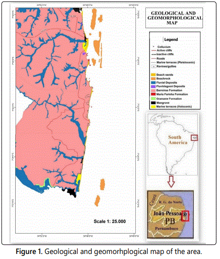
The south coast is located in the topographic chart of João Pessoa plane (SB-25-YC-3), scale 1: 100,000, elaborated by the Army Ministry. The geology of the area is associated with Paraiba sedimentary basin. Such sediments were deposited as the South American continent withdrew from the African continent [11], over a crystalline basement deformed by shear zones [12]. This basin can be subdivided into three sub-basins: Olinda, Alhandra and Miriri sub-basins. The study area is part of the Alhandra sub-basin, border to the north by Itabaiana fault and to the south by Goiana fault.
The sedimentary deposit events of the Paraiba Basin are dated from the late Turonian, when the lands both to the North and to the South of the Pernambuco Shear Zone were reactivated [13], as the South American continent moved away from Africa, starting the land subsidence of the Paraiba Basin, later regarding the basins to the north and to the south, Potiguar and Pernambuco, respectively, which have already demonstrated sedimentary deposits from the Barremian/Aptian [13,14].
In this period (between the Coniacian and lower Campanian), the basin's sedimentation has begun [15], even in continental conditions, depositing sandstones and conglomerates of Beberibe Formation, 360 m thick [15], representative of a high-energy river environment [14], resting unconformably on the bottom. This includes the Alto Moxoto Terrain, composed of granodioritic and granolithic orthogenesis and metamorphosed volcanic rocks on amphibolite facies (biotite schist, biotite-gneisses and greywackes) of the Paleoproterozoic age [16]. The Paraiba Basin resisted the rifting process until the Late Cretaceous [17], being the last link with Africa.
With this subsidence, forming a gentle slope inclined to the east-type homocline [18] and subsequent disruption of the link between South America and Africa, the terrain begins to be invaded by the sea, gradually depositing marine carbonate sediments from the Itamaraca Formation, 70 m-thick, dating from the Upper Campanian, indicative of a transgressive stage that will continue throughout the Maastrichtian, under hot and dry climatic conditions [13]. The maximum drowning of the basin, whose marine waters hamper the deposition of clastic to its interior, is represented by a phosphatic level dating from the Campanian [19], which limits the Itamaracá Formation of the posterior formation, 70 m thick, representative of a tract of high sea already with calm and shallow water, whose carbonate deposition is represented by several facies of the limestone from the Gramame Formation, occurring initially in the Upper Campanian [20,21], and extending around all Maastrichtian.
At the end of Maastrichtian, the ocean floor expands, starting a regressive marine event, meaning the marine platform begins to be exposed and weathered [15]. During the Paleocene, this regressive stage is characterized by highly fossilized carbonate deposition from the Maria Farinha Formation, representing a low and open marine environment [22,15] in more humid climatic condition [13]. This formation outcrops abundantly in the form of dolomitic limestones on the southern coast of the area, especially in the municipality of Conde.
The Barreiras formation, from the upper-Plio-Pleistocenic age, is considered a platform coverage of the Paraiba Basin, which sediments are the result of weathering from the outcropping crystalline shield in Borborema Plateau [23], distant about 30 km from the coast and were deposited in a braided river environment (represented by gravel and coarse to fine sand) on alluvial fans (intercalated conglomerates intercalated a thinner silty-clay layer), under an arid climate. Its average thickness is 40 m, reaching 80 m [24].
Above the Barreiras Formation were deposited quaternary sediments, representative of a marine/transitional environment (Pleistocene and Holocene marine terraces, rocky and algalic-coralineous reefs, mangroves and beach sands named ‘beach rocks') and of a continental environment (colluvial deposits, cones of dejection, inactive dunes and alluvial deposits), through new spaces created by faults reactivated in the Neogene and Quaternary ages [25,26], among others.
From the Pliocene, as a result of the establishment of a stress field in the South American plate, with compression oriented E-Wand N-Sextension, a series of adults that hit the over lapping sediments were reactivated, having a crucial role in coastal morphology and tracing of the hydrographic network [27].
The area belongs to the geomorphologic unit of Plains and Coastal Tablelands, according to Ross [28], having direct relation with ancient tectonic movements, generated during the drift of the South American and African plates [18], added to Cenozoic tectonic events [27,25], (among others).
We can identify three subunits in the south coast of Paraiba state: the coastal plain, low coastal upland (‘Coastal Tablelands') and floodplains, which can be still subdivided into fluvial and fluvial-marine floodplains. The top of the tablelands is linked to the plains in relatively steep slopes, in form of cleefs, with great scenic beauty, in the shore.
The coastal lowlands are in direct contact with the sea, have altitudes between 0 and 10 m, which quaternary sedimentation of river, marine and river marine origin filled the coastal plain, resulting in numerous geomorphological features that can be considered geomorphosite for its scenic beauty and/or relevant geological/geomorphological history. The low coastal uplands, also known as ‘Coastal Table lands', correspond to a higher, gently sloping portion of the land, with flat top, generally inclined to the east, result from the action of exogenous agents that carved the Barreiras Formation, including marine abrasion on cliffs, another outcrop form of this formation on the coast, at its eastern portion.
According Brito Neves et al. [16], these low coastal uplands were results of large arching and a succession of steeped pediplains to inland, subordinated to paleoclimate, whose graben-horst type structure controlled its morphology. Reactivation of basement shear zones with E-W and NE-SW direction, from the Early Cretaceous, reach the sediments of the Barreiras Formation, forming fault scarps that are capped by alluvial terraces, sandstone dunes, debris slopes, soil and vegetation, and which serve as bounds of the river valleys, while the upraised portions were dissected [28]. Figure 1 shows the geological and geomorphological map of the area.
A View of the Geoheritage of the Area
The sites of geoturistic use interest proposed here are inserted in one of two morpho sculptural compartments, named coastal plains and low coastal uplands, besides the slopes that limit the low plains of the coastal plains.
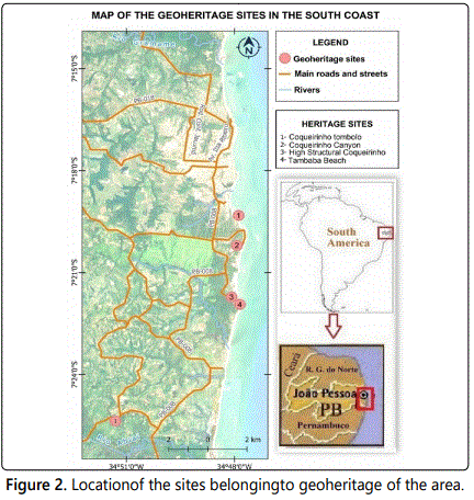
According to the aesthetic, cultural, scientific, economical and ecological values, four geoheritage sites were selected in the coast of the area (Figure 2). Are they:
Site 1. Coqueirinho Tombolo
Coqueirinho Beach, easily accessible by PB-008, is the main tourist destination on the south coast, according to IFEP [29]. With an extension of about 5 km, it is the most extensive of the south coast, and can be divided into two parts: to the north, with about 3300 meters, is relatively straight (or with two inlets quite open), with the highest cliffs of the state, showing features of continental erosion, with colluvial and talus deposits; to the south it is constituted by three inlet, giving a crenulated aspect to the coast when seen on a smaller scale, separated by rocky groins. These groins play a key role in the formation of the tombolo (Figure 3). Between the two parts are the restaurants and bars.
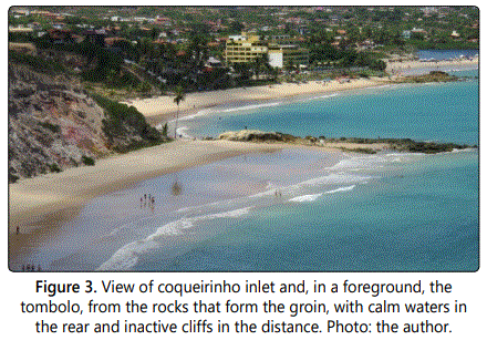
It corresponds to a geomorphosite with very high aesthetic value and high scientific value. The groin is formed by limestones of the Maria Farinha Formation (base) and ferruginous sandstones of the Barreiras Formation (top). These groins are responsible for the generation of shade areas that accentuate the deposition of sediments, widening the beach in its rear and forming the tombolo, while in bar lamar the effect of diffraction accentuates erosion, narrowing the beach, but leaving the waters calmer, an excellent place for bathing. Completing the landscape, it has inactive cliffs with vegetation that will embellish it even more.
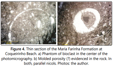
The limestone, of reef origin, presents a set of joints, with main direction E-W and normal and transcurrent faults, these with right sense, visible by means of iron oxide veins. In thin sections, its composition is 95% of calcite crystals and 5% of pores, having no apparent bioclast and no matrix or some other allochemical grain, however it is possible to detect “ghosts” (skeleton-like forms of some bioclasts, figure 4a) and some void spaces resembling bioclasts (Figure 4b). The rock can be classified as a Recrystallized Biomicrite [sensu Folk] [30] or Recrystallized Mudstone [31]. As there are no other elements for a more accurate analysis of the diagenetic events, we can interpret in chronological order: as a Mesodiagenesis event, the recrystallization of the matrix and halo chemical (transformation of bioclasts formed by aragonite in calcite and of the matrix in calcite), dissolution of the constituents (bioclasts generating cellular pores and intraparticle porosity) and dolomitization.
Even if it is part of Tambaba's Environmental Preservation Area (EPA), monitoring of buildings and visitors regarding environmental impacts on the beach, biodiversity and surrounding cliffs is minimal. The allotment of areas for the construction of parking lots causes the deforestation that, therefore, intensifies the erosive effects, causing a succession of problems. Outcrops of ferruginous and limestone sandstones suffer from trampling and marine overlap, accentuating their destruction.
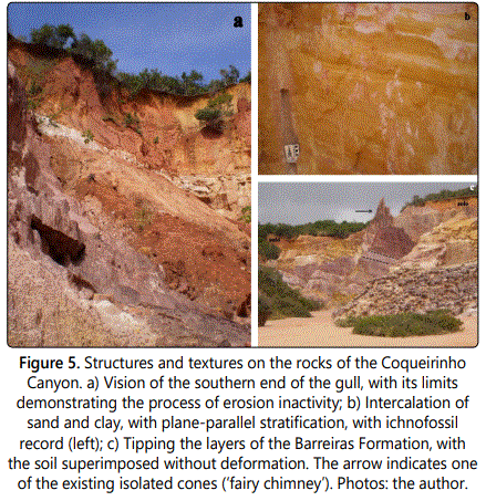
Site 2. Coqueirinho Canyon
It corresponds to an imposing gully, whose access is by the Coqueirinho Beach, by a road through the coconut trees 750 meters to the south of the main beach. You can get in with an automobile, but it is suggested that you park at your entrance and follow walking.
It corresponds to a geosite with very high aesthetic and scientific value. Its exceptional scenic beauty has made it a must-visit tourist spot on the south coast. These gullies, in the rainy season, form small streams that pour tons of sediment into the ocean, forming cones of dejection. By the configuration of the profile of the coast, to barlamar, and considering the coastal drift from south to north, these sediments end up being loaded and deposited in adjacent beaches. Considering that they are in continuous process of formation, the instability of this type of shape threatens roads and affects soil productivity, harming agriculture.
The process of formation of the gullies is associated with the superficial water erosion, which causes the initial formation of deep and narrow grooves, the ravines that, not contained, evolve and lead to larger gullies.
The Coqueirinho gully has asymmetric slopes, greater than 100%, length of about 1 km, 160 meters wide and a depth that reaches 40 meters. It has a main axis in the SW-NE direction, the most evolved stage of the ravinization that gave rise to it. Subsequently, smaller ravines were formed, currently in evolution (figure 5a), perpendicular to the major gull. This ravine needs to be contained urgently to minimize its evolution until complete stabilization.
The geological substrate in which the gull is developed is extremely diverse. It ranges from fine to coarse sandstone and argillite/lamite, with plane-parallel stratification to conglomerates. There is a presence of facies showing thinner clay layers, interspersed with thicker sandy layers, with structures of bioturbation (icnofósseis, figure 5b). It may correspond to tidal cycles, which would confirm the marine origin of the formation or an environment of mixture of saline and sweet waters, like an estuary. They also show a dip and faults in various directions (figure 5c) and folds, which combine with the structural activity for their formation, as well as numerous isolated conical forms, one of them popularly known as ‘Little castle', which can be seen from a belvedere on the top of the board, a must visit for anyone who strolls through the southern coast [32].
According to Furrier [33], these gullies developed as a consequence of an accelerated headwaters retreat, of extremely rapid evolution, with a strong carving of the adjacent tablelands, due to the uplift of the terrain that gave rise to the Coqueirinho Structural High. This tectonic feature was selected as geosite (site 3). The anthropic action contributed to the intensification of the process, with deforestation at the top of the tablelands, due to the construction of real estate and road layout, added to the intense rains in the winter period.
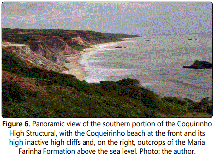
Site 3. Coqueirinho High Structural
Tambaba belvedere is the ideal place to visualize part of the features that corroborate with the existence of the structural high that corresponds, a horst having altitudes above 120 m and EW direction, with very high scientific and aesthetic value. Is located 130 meters from the “entrance” to Tambaba Beach, from where has a vast view of part of the high structural, beaches of Tambaba and Coqueirinho and associated rocky outcrops (Barreiras sandstone and Maria Farinha limestone, figure 6).
Furrier et al. [34] and Furrier [33] analyzed the behavior of the hydrographic network between the Gramame River and the Grau River by orbital images, topographic and geological maps, aerial photographs and field work, associating it with the relief of coastal tablelands, in an area that covers the southern coast of Paraíba, almost entirely.
About the Gramame River, the authors concluded that its valley is limiting two distinct morphostructural units. In the north, the tablelands have more extensive surfaces and altitudes inferior to the south portion, with rivers aligned according to a trend SSE-NNW influenced directly by the faults of the same direction. However, this network exhumes with less intensity the sedimentary formations of the Paraiba Group, since the limestone of the Gramame Formation outcrops punctually in the Miriri and Paraiba river valleys. The variation of the altitude of the tablelands evidences uplifts and down lifts of the terrain, with the highest altitudes to the south of the Miriri River (122-177 m) and the smaller ones between the Paraiba River and Gramame River, where João Pessoa is located (49-77 m).
On the other hand, south of Gramame River, it presents the relief more dissected by the network of drainage, where the tablelands do not extend by a very great area and the altitudes are bigger, reaching 210 m. They have semi-convex, slightly developed, tops, different from the tabular format of the northernmost area. The trajectory of some rivers changes abruptly its direction, like the Gramame, Graú and Mucatu river, result of the upliftment of part of the land, where the Gramame Formation limestone appears in the right margin of the river, whereas in the left margin it is only found in tubular wells about 20 m deep. In Coqueirinho Beach are found the highest cliffs of the State, up to 40 m. However, they are inactive cliffs, in some areas covered by vegetation and with evidences of continental erosive processes, such as solifluction, landslides, mud and debris flow, among others, resulting from a marked dissection of the terrain with intense retreat in the drainage headwaters.
Site 4. Tambaba Beach
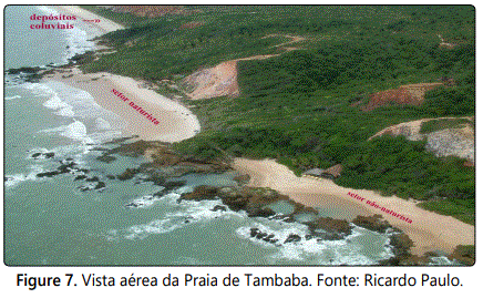
The geosite, with high cultural and functional values, corresponds to an extensive area that extends along the Tambaba Beach, with access by the PB-008, making up the main inlet near the parking lots and tourist infrastructure (non-naturist sector). About 130 meters long, the adjacent inlet to the north, no more than 30 meters, offers access by trails that enter the forest. Another adjacent inlet, to the south (naturist sector), about 250 meters in length, is separated by two small spurs of limestone reef and the beach to the south, rectilinear, extends for another 910 meters (Figure 7).
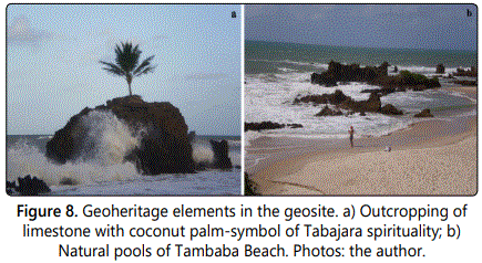
This beach was considered a sacred place for the indigenous Tabajara where, in a remote past, they buried their dead. The outcrop of Maria Farinha limestone, with a coconut tree at the top, located in the styrene-antepraea border (Figure 8a), has a spiritual meaning for this ethnic group [35] and denotes the cultural value, in its spiritual bias, of this element of geodiversity. The beach has an infrastructure of bars, surrounded by vegetation and with an inactive forested cliff at the base, at the rear. In the main inlet, the outcrops of limestone on the beach form beautiful natural pools in the quadrature tides (Figure 8b).
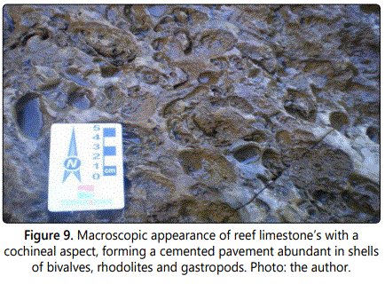
These deposits of reef limestone scan are classified, according to Folk [30], in calcilliths, calcarenites, laminites and limestone with a cochinoid aspect, bearers of molds of bivalves and gastropods (Figure 9). Arranged in a chaotic form, they have a secondary porosity, a consequence of the dissolution of the shells. This faciological variation can be found in vertical profiles of few meters and denote different depositional environments, respectively, beach, interreefs, lagoon and reef.
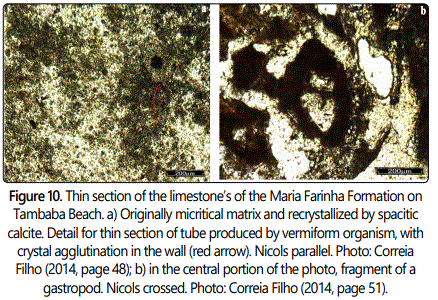
Correia Filho [32] made a thin section of the cochinoid limestones, due to its paleontological importance and its greater representativity in the area. This rock, considering the proposal of Folk [30], was classified as a biosparite [or ‘mudstone', according to Dunham's proposal] [31], cemented originally with a micrite and recrystallized by spastic calcite (Figure 10a). The siliciclastic contribution is minimal, restricted to a few grains of fine quartz and K-feldspar, which presupposes that the deposition occurred on a restricted platform, which made it difficult to influx sediments. The presence of euhedral crystals with up to 10 μm of dolomite shows a dolomitization process. These crystals have edges recrystallized by calcite cement, in a late form, which characterizes a dedolomitization process, evidencing different diagenetic processes. The rock, with evidence of oxidation (as a consequence of the weathering process) and phosphatization, has as bioclastos fragments of bivalve and gastropod shells, recrystallized or dissolved and tubes of excavators with oxidized walls (Figure 10b).
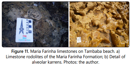
To the north of the main inlet, trails that enter the spur will go towards small beaches. The limestone's, located in these paths between the Atlantic Forest and also on the beach, are richly fossilized with allelic rhodolites, belonging to the genre Archeo lithothanium sp (Figure 11a) and with numerous dissolution features, such as alveolar karren (Figure 11b). These karrens are consequence of the formation of micro fractures with the secondary organic action (lichens, algae, mosses and roots).
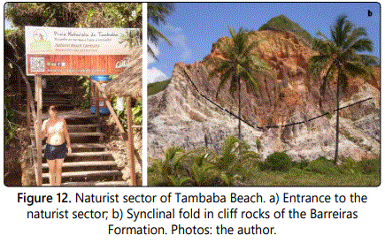
From this beach, at its southern end, by a trail through the Atlantic Forest there is naacessto a new, more extensive inlet, where is the Naturist Beach of Tambaba (Figure 12a), which culminates in fringes of the limestone Maria Farinha. The Naked Tambaba Association was created in 1991, based on municipal decree no. 276, which authorizes the practice of naturism as a standard for access to the beach, being the first nudist beach in the Northeast Brazil. According to officials, the beach, in the high season (December to February) reaches 200 tourists a day. To the rear, an inactive cliff with about 30 meters of height shows marked continental erosion.
Farther south of the naturist sector, for about 800 meters, the base of the cliffs has colluvial deposits, forested, in the rear of a berm line that protects it from marine overlap. Almost at the end of the beach, before reaching the Holocene marine terrace that marks the beginning of Grau Beach, a cliff has folded rocks (of the syncline type), which corroborates the existence of neotectonism (Figure 12b). On a larger scale, it can be seen that its layers are cut by extension and transcurrent faults, with slips less than 80 cm.
Conclusions
Tectonics played a key role in the configuration of coastal relief, while exogenous agents, such as marine regressions and transgressions, present and past climates, biological and anthropogenic agents, among others, modeled and formed the beautiful forms of relief. At the moment when human beings value places of interest, these sites have a heritage value, deserving to be safeguarded for future generations, which is one of the principles of geoconservation.
Based on previous studies on the geology and geomorphology of the area and on pre-established criteria such as scientific, cultural, aesthetic, ecological and economic value, a number of sites were identified at various scales. The region is a tourist destination known in Brazil from the point of view of sun and sea tourism.
It is therefore pertinent to interweave this heritage to tourism in the area, so that more motivation arouses the interest of tourists, now turned to the bias of the lithosphere and hydrosphere. It can be concluded that the municipalities of João Pessoa and Carabelo have geopolitical potential. This practice still remains incipient, and the inventory of this heritage with the intention of disseminating the Geosciences, is necessary and is of paramount importance for coastal management and planning.
Acknowledgment
The author is grateful to Capes-CSF for the funding of this research, through the scholarship for the PhD in Physical Geography, by the University of Coimbra (process nº 11988-13/4).
References
- Panizza M. Geomorphosites: Concepts, methods and examples of geomorphological survey. Chinese Science Bulletin. 2001; 46: 4-6. doi: 10.1007/BF03187227
- Reynard E, Panizza M. Geomorphosites: definition, assessment and mapping. Geomorphology: Relief, Process, Environment. 2005; 11(3): 177- 180.
- Reynard E. Geomorphosites and landscapes. Geomorphology: Relief, Process, Environment. 2005; 3: 181-188.
- Pereira LS, Cunha LS, Vieira R. Potential sites of geothermal interest in Joao Pessoa (PB) and the State coast. Geography Paths. 2016; 17: 211-223. doi: 10.14393/rcg176015
- Cunha L, Vieira A. Geomorphological Heritage, Resource for Local Development in Mountain Spaces. Examples in Central Portugal. Geography Books, Coimbra. 2004; 21(23): 15-26.
- Françolin JBL, Szatmari P. Mechanism of rifteamento of the eastern portion of the north Brazilian margin. Journal of Geosciences. 1987, 17(2): 196-207.
- Petri S. Cretaceous paleogeographic maps of Brazil. Palaeogeography, Palaeoclimatology, Palaeoecology. 1987; 59: 117-168.
- Barbosa JA, LimaFilho MF. Structural and stratigraphic aspects of the Recife-Natal coastal strip: observations in well data. Petrobras Geosciences Bulletin. 2006; 14(1): 287-306.
- Barbosa J, Souza E, Lima Filho M, Neumann V. The Stratigraphy of the Paraiba Balance: A Reconsideration. IG. Series B, Studies and Surveys. 2003; 13: 89-108.
- De Brito Neves BB, Riccomini C, Fernandes TMG, Sant'anna LG. The Tertiary Tafrogenic System of the Outstanding Northeast East in Paraíba: A Proterozoic Legacy. Rev Bras Geoc. 2004; 34(1): 127-134.
- Mabesoone J, Alheiros M. Origin of the Sedimentar Coastal Balance Pernambuco-Paraíba. Rev Bras Geoc. 1988; 18(4): 476- 482.
- Asmus H. Structural Control of Mesozoic Deposition in the Bay of the Continental Margin Brazil. Rev Bras Geoc. 1975; 5(3): 160-175.
- Lima Filho M, Souza E. Stratigraphic framework in calciferous sandstones of the Campania of the Paraíba Basin: Stratigraphy and paleoenvironmental significance. Simp Geol Nord.19. Anais. Soc Bras Geol. 2001; 87-88.
- Tinoco I. Foraminíferos and the passage between the Cretaceous and the Tertiary in Pernambuco. PhD Thesis (Doctorade in Geology), University of São Paulo, São Paulo. 1971.
- Lima MG, Vasconcelos P, Farley K, Jardim de Sá EF. Weathering dating delimits the age of the Barreiras Formation, Northeast Brazil. Cong Arms Is Quat. 2007. Anais. Belém: ABEQUA, CD-rom.
- Bezerra FH, Vita-Finzi C. How active is a passive margin? Paleoseismicity in northeastern Brazil. Geology. 2000; 28(7): 591-594. doi: 10.1130/0091-7613(2000)28<591:HAIAPM>2.0.CO;2
- Rossetti D, Góes AM, Valeriano MM, Miranda MC. Quaternary tectonics in a passive margin: Marajó Island, northern Brazil. J Quat Sc. 2008; 23(2): 121-135. doi: 10.1002/jqs.1132
- Bezerra FHR, Amaro VF, Vita-Finzi C, Saadi A. Pliocene-Quaternary fault control of sedimentation and coastal plain morphology in NE Brazil. Journal South American Earth Science. 2001; 14(1): 61-75. doi: 10.1016/S0895-9811(01)00009-8
- Ross J. Brazilian Relief: A New Proposal for Classification. Journal of the Department of Geography of FFLCH/USP, São Paulo. 1985; 4: 25-39. doi: doi.org/10.7154/RDG.1985.0004.0004
- Folk RL. Spectral subdivision of limestone types. In: Ham WE (ed). Classification of Carbonate Rocks. American Association of Petroleum Geologists Memoir. 1962; 1: 62-84.
- Dunham RJ. Classification of carbonate rocks according to their depositional texture. In: Ham WE (ed). Classification of carbonate rocks. American Association of Petroleum Geologists Memoir. 1962; 1: 108-121.
- Furrier M, Araújo ME, Menezes L. Geomorphology and tectonics of the Barreiras formation in the State of Paraíba. Rev Inst Geoc-USP. 2006; 6(2): 61-70. doi: 10.5327/S1519-874X2006000300008
- Farias E, Barcellos LA. The Religiousity of the Indigenous Tabajara of Paraíba. National Seminar on Teacher Education for Religious Education. 13, Belém Anais Belém: FONAPER, 2014.
