

Editorial Article
Tectonic Ledges at the Ladoga Lake Bottom
1Herzen State Pedagogical University of Russia, Russia
2 Institute of Limnology RAS, St.-Petersburg, Russia
3 Pushkin Leningrad State University, Russia
*Corresponding author: V.M. Anokhin, Herzen State Pedagogical University of Russia, St.-Petersburg Russia, E-mail: vladanokhin@yandex.ru
Received: December 06, 2023 Accepted: December 12, 2023 Published: December 22, 2023
Citation: Anokhin VM, Dudakova DS. Tectonic Ledges at the Ladoga Lake Bottom. Int J Earth Sci Geol. 2023; 5(1): 134-138. doi: 10.18689/ijeg-1000118
Copyright: © 2023 The Author(s). This work is licensed under a Creative Commons Attribution 4.0 International License, which permits unrestricted use, distribution, and reproduction in any medium, provided the original work is properly cited.
Abstract
Over the past few years, the Institute of Limnology of the Russian Academy of Sciences has been conducting extensive studies in Lake Ladoga, with special emphasis on the bottom geology and geomorphology. Since 2018, we have applied underwater robot vehicle (ROV) with video cameras. By the ROV we have discovered new geological and geomorphological properties of the lake, including the presence of underwater sub-vertical ledges, composed of several tens of meters high rock formations with tectonic origin.
Keywords: Bottom relief, Lake Ladoga, underwater vehicle, ledge, bedrock, fault
Introduction
The large lakes of Finland and Sweden and the northern part of Lake Ladoga are located within the Svecofennian tectonic geoblock of the Fennoscandian crystal shield, which causes the similarity of the geological structure of the coastal parts and the bottom of the water area of these reservoirs [13]. The bottom of Lake Ladoga in the lower part of the geological section is composed of complexly dislocated metamorphic and intrusive rocks of the Paleoproterozoic, above them there are gently inclined volcanogenic-sedimentary and subvolcanic Riphean complexes. The crystalline bedrocks within the water area are exposed on the tops of the hills and steep slopes, and for the most part is overlain by glacial deposits of the Pleistocene and modern lake sediments. Tectonic structures in the form of a horst-graben system of blocks were formed in the Proterozoic [19], but at present high tectonic activity remains during the isostatic uplift of the shield, which is confirmed by seismic observations. Fresh landslides, ledges not affected by weathering, gaping cracks are observed on the coastal land [25]. The landscape elements of the water area are an underwater continuation of the relief forms developed on the coast and islands. To ensure the geo-ecological safety of coastal structures and underwater communications from possible threats associated with increased seismic activity, it is necessary as one of the measures to study interblock fault zones, including within the water area on steep ledges of underwater relief.
The bottom morphology of Lake Ladoga, the largest lake in Europe, has been studied for many years. A number of organizations took part in these studies [e.g. Karpinsky Russian Geological institute (VSEGEI), NS-geologia, Gramberg Russian institute of geology and mineral resources of the Ocean (VNIIOkeangeologiya), Institute of limnology of the Russian Academy of Sciences (IL RAS), Arctic and Antarctic Research Institute (AARI), St. Petersburg State University, Institute of Water Problems of the North of the Russian Academy of Sciences], and a vast number of results have been published [e.g.1-10, 12, 14-18, 20].
New methods like ROVs and underwater cameras give us many new possibilities to study the bottom layers of shallow and deep lakes and shores, very interesting while still poorly studied environments. Their specific characteristics in terms of relief, geological origin, type of sediments etc. are crucially important to know also when organisms such as fish, amphipods etc. will be studied. Like in oceans, in lakes underwater “world” is poorly studied in comparison to above water environments. I believe the reason, that bottom areas of the lakes have been largely ignored, has been the lack of proper technical instruments/ devices. Therefore, now it is time to put much more effort on those environments when we have the new tools to bring bottom areas visible. Over the past few years, IL RAS has been conducting geological and geomorphological studies of the bottom of Lake Ladoga. Starting in 2017, these studies began to use underwater photo and video cameras created at IL RAS [11]. Thanks to the use of this new research equipment, several interesting facts of the structure of the bottom were discovered, in particular, in the northern part of the lake, the camera recorded several underwater sub-vertical ledges, composed of bedrocks, several tens of meters high.
Despite the large amount of accumulated material, subsequent studies carried out with the use of new instruments often lead to the discovery of new data on the structure of the bottom of Ladoga.
This publication aims to characterize this phenomenon, make assumptions about its age and genesis, since any processes occurring in Lake Ladoga affect the quality of its water and need identification, assessment and observation.
Material and Methods
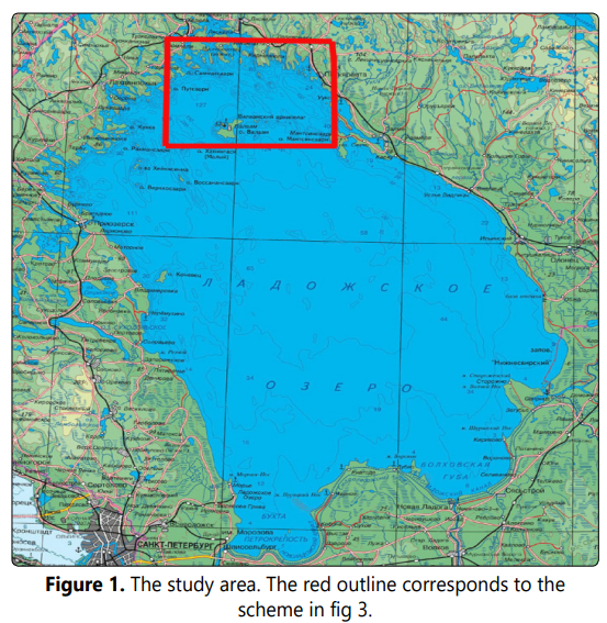
It is known that the bottom of Ladoga (Fig. 1) has a rather complex relief, especially in its northern part, located within the Baltic crystalline shield [25]. The bottom topography here has a high degree of dissection (depth differences of 100-200 m) and is characterized by the predominance of linearly elongated topography forms, mainly of northwestern strike. All found subvertical scarps are located in the northern part of the lake, with a high dissection of the bottom topography.
To the south, the slopes of the Baltic shield gently sink under the sedimentary cover of the Russian Platform, crystalline rocks are overlapped by an increasingly thick stratum of sedimentary Riphean, Vendian and Phanerozoic deposits. The surface of the late Vendianpeneplen gradually sinks into the southeast from -100 m in the central part of the basin (along the border of the cover) up to -300 m in the southern region the coast [2]. The relief becomes less dissected (depth differences 1-10 m). Forms lose their clear direction and linearity.
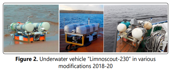
The described ledges were discovered in the course of landscape bottom studies during underwater photo and video shooting of the bottom using the Limnoscout-230 underwater vehicle, designed at IL RAS specifically for use in Lake Ladoga (Fig. 2). This apparatus has a number of design features that allow it to successfully (for the first time in history) photograph the bottom of Ladoga. These features are listed below:
- estimated operational depth appr. >300 m;
- operating speed of towing 1-2 km/h;
- the high resolution of the cameras allows to highlight small relief details, geological formations, biota elements, etc.
- the light system is adjustable and allows to work with water of increased turbidity;
- a reinforced metal frame structure, together with the installation of the main functional units of the apparatus on elastic elements, allows it to withstand collisions with rocky outcrops and stony debris at operating speeds;
- the existence of an effective system for the release from fishing nets;
- high stability at working speeds;
- it is possible to work from a ship, boat or autonomously;
- high mobility and maintainability [11].
The vehicle was towed at a height of about 0.5 m above the bottom, across the strike of relief structures. Upon collision with a ledge in its lower part, the apparatus began to ascend with simultaneous photographic and video recording of the ledge. At the same time, the towing boat stood in one place, and the camera was lifted vertically upward from depths of about 100 - 120 meters to depths of 20 - 30 meters with continuous visual contact with the ledge. During the ascent, the camera fixed a vertical wall composed of bedrocks, sometimes with negative angles.
Results and Discussion
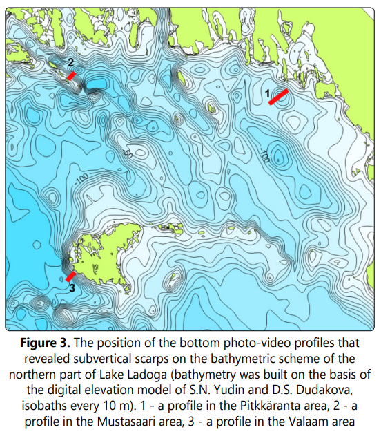
All the found ledges are located in the northern part of the lake, in three regions: on the side of a depression near the town of Pitktäranta, on the slope of the Mustasaari island ridge and on the western underwater slope of Valaam Island (Fig. 3).
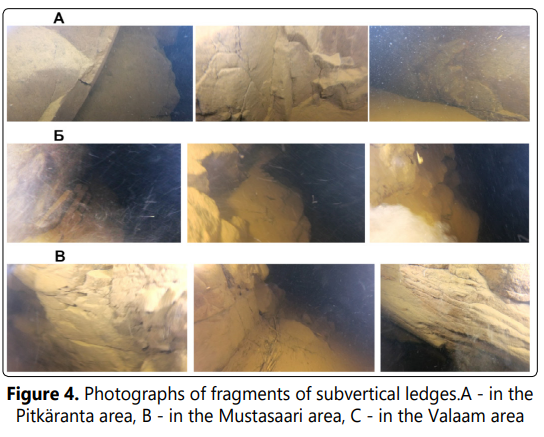
Fig 4. shows the detected ledges within the boundaries of the capture area of the camera. Similar patterns were observed and recorded throughout the ascent of the chamber from depths exceeding 100 m to 20-30 m.
The photographs show the bedrock outcropping in the sub-vertical scarp, divided into blocks by fracture systems. The blocks have sharp edges without any traces of wave processing. No traces of glacial treatment were found either.
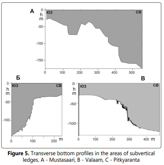
Fig. 5 shows the profiles built across all three ledges on the basis of combined echo sounder data and satellite positioning of the device’s contacts with the wall. The Pitkäranta profile (Fig. 5A) shows the relief of a small basin NW strike, the NE side of which has a rather gentle slope, and the SW side is a steep scarp with a total height of about 70 m; the vertical part itself has a height of 30 m. Towards the foot, at a depth of about 125 m, the scarp flattens out, probably due to colluvial talus; when joining with a flat bottom, the angle does not exceed 10 °. In the upper part, the flattening of the ledge occurs in the form of steps, separated by dips with vertical walls up to 10 m deep.
Fig. 5B shows the bottom profile in the area of the southwest slope of the underwater valley near Mustasaari island. On this profile, we can see a stepped slope with two sub-vertical walls, a lower height of up to 50 m (depths of 100-150 m) and an upper height of 20 m (depths of 70-90 m). In addition, closer to the coast there is a depression with a trough-shaped transverse profile 30 m deep (40-70 m deep) with very steep slopes, 50-70°.
SW slope of Valaam island (Fig. 5B) is represented by a series of sub-vertical scarps with heights of up to 10 m, separated by sub-vertical dips, with a total height of about 100 m. The total slope in the steepest part of the slope is about 90 °.
The size and shape of all three ledges are indicative of their tectonic origin.
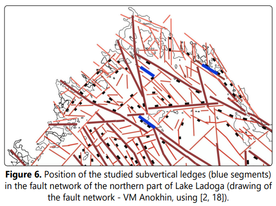
When comparing the spatial position of the discovered scarps with the existing tectonic schemes, they almost completely coincide in position and strike with the known fault zones (Fig 6).
When comparing the spatial position of the discovered ledges with the existing bathymetric maps, they were found to coincide with the linearly elongated slopes of the NW strike on the sides of the depressions, which, considered steep, do not exceed 40-50° in slope. In all likelihood, the discovered scarps correspond along the strike to these slopes and can be traced along them.
Summarizing the above, we can say the following. By composition (bedrock), morphology (high subvertical linear-elongated scarps) and spatial correspondence to known fault zones, these ledges can be recognized as morphological expressions of tectonic objects - faults of a substantially fault type. The absence of visible traces of glacial processing on the bedrock blocks may indicate a very young, postglacial age of the formation of these scarps and, accordingly, rather powerful Holocene tectonic movements in the area of Lake Ladoga.
Several authors [2, 21, 22] wrote about the possibility of the existence of such ledges at the bottom of the northern part of Lake Ladoga. However, the listed publications dealt with single scarps up to several tens of meters high and with slopes up to 60°. Indeed, the geophysical methods of studying the bottom applied in these studies did not make it possible to detect vertical walls. The echo sounder profiling of the bottom, repeatedly carried out by the authors across the found ledges, also did not give significant results - above the vertical wall echo sounders of two different types showed only zones of loss of correlation. Thus, only a visual study of the bottom with the help of an underwater vehicle made it possible to see a real picture of the presence of a number of large young tectonic scarps at the bottom of Lake Ladoga. In the future, this study will be continued, including in areas where it is possible to discover new ledges or other geomorphological objects.
Conclusions
Based on the results of this study, following conclusions can be drawn:
- At the bottom of the northern part of Lake Ladoga, three subvertical ledges, composed of bedrocks, up to 70-100 meters high were found
- Based on the composition (bedrocks), morphology (high subvertical linear-elongated scarps) and spatial location of the fault zones, the scarps can be recognized as morphological expressions of tectonic objects – faults;
- The absence of visible traces of glacial processing on the blocks of bedrocks, one can assume the Holocene age of the formation of these scarps and, accordingly, the existence of the latest tectonic movements in the area of Lake Ladoga.
Acknowledgements
This study was supported by the two projects: Russian State Project IL RAS No. FMNG-2019-0001 “Comprehensive assessment of the dynamics of ecosystems of Lake Ladoga and water bodies of its basin under the influence of natural and anthropogenic factors” State registration No. AAAA-A19-119031890106-5, and Russian State Project of St. Petersburg Scientific Center of the Russian Academy of Sciences 82.1 FNI “Development of the theory of transformation of the scientific and innovative space of St. Petersburg in the context of the development of the Russian economy, taking into account the theoretical and methodological foundations of sustainable technological development of the region on the basis of innovation and investment activities and reproduction and the formation of scientific and educational potential of St. Petersburg “.The authors express their deep gratitude to M.O. Dudakov for participating in this study.
References
- Anokhin VM, Naumenko MA, Nesterov NA. The relief of the bottom of Lake Ladoga and its relationship with disjunctives. Russian Geographical Society. 2016; 148(2): 44-51. (in Russian) 9. Anokhin VM, Naumenko MA, Subetto DA, Nesterov NA, Rybakin VN. Features of the geomorphological structure of the bottom of Lake Ladoga. In the book: Geography: the development of science and education. Collective monograph based on the materials of the International Scientific and Practical Conference LXXI Herzen’s Readings. 2018; 442-448. (in Russian)
- Petukhov SI, Anokhin VM, Naumenko MA. The first experience of morphotectonic modeling of the Ladoga Lake area. In the collection: Geography: the development of science and education. Collective monograph based on the materials of the annual international scientific and practical conference. 2020; 147-151. (in Russian)
