

Case Study
New Insights for Explaining the Expansion of Tributyltin in Northern Part of Kuwait and Kuwait Bay
1Kuwait Ministry of Public Health, Kuwait
2Kuwait Institute for Scientific Research, Kuwait
*Corresponding author: Amal J. Alkandari, Kuwait Ministry of Public Health, Kuwait, Email: a.j.alkandari@windowslive.com
Received: October 26, 2021 Accepted: November 09, 2021 Published: November 16, 2021
Citation: Alkandari AJ, Kamel H. New Insights for Explaining the Expansion of Tributyltin in Northern Part of Kuwait and Kuwait Bay. Int J Earth Sci Geol. 2021; 3(1): 105-110. doi: 10.18689/ijeg-1000114
Copyright: © 2021 The Author(s). This work is licensed under a Creative Commons Attribution 4.0 International License, which permits unrestricted use, distribution, and reproduction in any medium, provided the original work is properly cited.
Abstract
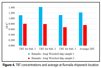
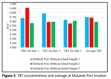
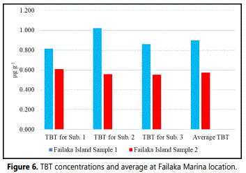
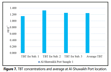
The marine environment of Kuwait is influenced by the anticlockwise Arabian Gulf current movement. Tributyltin (TBT) concentration is found in the northern part of Kuwait and Kuwait Bay marine sediments. The results showed the presence of TBT in 9.5 % of the total surface sediment samples. TBT was detected in two of the four triplicate samples at Rumaila–shipwreck with an average of 1.222 µg g-1 dw in sample 1 and 0.759 µg g-1 dwin sample 2. In Mubarak Port TBT average concentration in three triplicate samples were 0.700 µg g-1 dw in sample 1, 0.578 µg g-1 dw in sample 2, and 0.589 µg g-1 dw in sample 3. In Failaka Island marina TBT average concentration in two replicate samples was 0.860 µg g-1 dw in sample 1 and 0.572 µg g-1 dw in sample 2. In Al-Shuwaikh Port near the dry dock, the TBT average concentration was 1.242 µg g-1 dw. Expansion of Tributyltin in the northern part of Kuwait according to the program, cover the eastern part of Bubiyan Island and in AlShuwaikh Port only near the dry dock. These concluded that TBT does not spread in areas. The levels detected are attributed to the transboundary effect sourced by shipwrecks in the NW Arabian Gulf and dry-docks in the adjacent countries. In addition, organotin degradation in the marine environment is regulated by both biotic and abiotic degradation and may be accelerated by UV radiation, increasing temperature, and biological activity. It is important to cooperate with neighboring countries on transboundary effects of potential pollutants.
Keywords: TBT, antifouling, transboundary effect, sunken vessels, Arabian Gulf
Introduction
The State of Kuwait is located northwest of the Arabian Gulf. The coast length of the State of Kuwait is about 325 km. There are 9 main Islands covering an area of about 922 km2 (Khalaf et al., 1984; Al-Sarawi, 1995; and Al-Yamani et al., 2004).
The main parameters controlling the oceanography of Kuwait are the tidal cycle, currents, and waves. The former represents the driving forces for the current pattern (Al-Yamani et al., 2004). The wave height in the Kuwait coastal zone attains up to 2m with a maximum of 3 - 4 m during stormy conditions. Tidal currents in the Arabian Gulf are characterized by counter-clock circulation. The mean range of tides (the between high tide and low tide) within Kuwaiti coasts is approximately 3m represented by twice-daily cycle (Al-Yamani et al., 2004).
The Kuwaiti marine environment is characterized as part of a riverine plume originated by freshwater influx from Shatt Al Arab with an annual discharge varying from 5 - 100 × 109 m3 (160 - 3.200 m3/s) as reported by Hartmann et al., (1971) and Grasshoff (1976) with a rate of 1000 m3/s (Reynold, 1993; Al-Yamani et al., 2004). The flow seasonally fluctuates indicating a high rate during the period March - June with a maximum discharge in May (Al-Ramadhan and Pastour, 1987). A considerable sediments load was transported by the river discharge of Shatt Al-Arab supported by further load discharged from Iraq represented by the Third River through Khor Al-Zubair and Khor Abdullah (Al-Yamani et al., 2004). Kuwait Bay according to Al-Ghadban (2004) was estimated by approximately 29 tons as a result of the oceanographic regime where this area is characterized as a low energy zone. Moreover, Kuwait Bay receives further suspended sediments from offshore areas and Shatt Al-Arab. The average rates of suspended solid deposition varied significantly between 0.16 and 1.00 cm y-11 for stations outside and within Kuwait Bay, respectively as illustrated in (Aba et al., 2014).
Kuwait Bay is an important feature in the Kuwait marine environment. The Bay is located to the north of Kuwait City as a large shallow water tongue, covering an area of approximately 720 km2 (Al-Shemmari, 2000). The Kuwait Bay extends 40 km into the mainland, with a maximum length of 45 km (east-west), and maximum width of 22 km (north-south). The length of the entrance between Ras Al-Sabiyah (north) to Ras Al-Ardh (south) is 19 km. Generally, the depth ranges in Kuwait Bay are between 5 m and 20 m (Dames and Moore, 1983) and it is separated from the estuarine flat and mainland coast by estuarine slope and shelf-slope (Al-Yamani et al., 2004). The contour depth in Kuwaitʼs territorial waters ranged between 2 - 30 m. The shallowest depth mostly characterized Kuwait Bay and the coasts of Bubiyan and Failaka. The depths in the northern part gradually increase westward to a maximum of 20 m. In the south, the depths steadily increase southward to a maximum of 30 m.
Water currents and sediment movement
Four current types characterized Kuwaitʼs territorial waters including surface ebb flow currents, near-bed ebb flow currents, ebb currents, and flooding from rivers (Al-Ghadban and El-Sammak, 2005). Surface ebb, flow currents are generated by the prevailing wind either northwest wind or southeast wind. Near bed ebb, flow currents are related to the movement of the bottom water that is counter-clockwise circulation in the Arabian Gulf. Ebb currents are generated by the high and low tides related to the gravitational pull of the moon and sun. As tides change, the current flows toward the coast and changes every 6 ¼ hours. The flooding from the Shatt Al-Arab and Karun rivers in the north discharges freshwater to the Arabian Gulf with a sediment load, particularly during the flood season (March-May). Recently, due to the diversion of Karun River, the sedimentation load may vary.
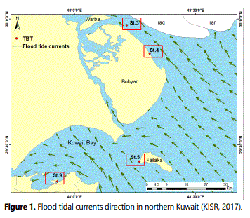
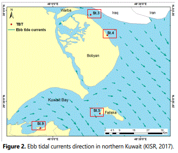
The low saline water mass flowing to the surface from the freshwater discharge of the Shatt Al-Arab in amounts of 1,000m3/s affects the current system in northern Kuwait (Reynolds, 1993; Al-Yamani et al., 2004). The impact of the freshwater discharge occurs in spring when the flow is at its maximum (5 - 100 × 109/m3) with a discharge rate of 160 - 3,200 m3/s. The currents in northern Kuwait are typically strong, although decelerate upon mixing with the highly saline water of the Arabian Gulf and its anti-clockwise current (AlRamadhan and Pastour, 1987; Grasshoff, 1976; Hartmann et al., 1971) as shown in Figures 1 and 2. In that territory, currents typically disturb the movement of suspended sediment (AlGhadban and El-Sammak, 2005).
Generally, shallow and broad flats in the northern Kuwait is characterized by the plume of suspended sediment from the Shatt Al-Arab, due to the bottom slope toward the south accelerating the water mass movement causing turbid condition notably during the ebb cycle and providing the opportunity to transport the freshwater load to the Kuwait Bay and Kuwaitʼs southern coast. On the Mesopotamian shallow shelf, the sedimentation depends upon shore morphology and the type of sediment, the assumed rate of which is varied from 0.03 to 2.5 mm y-1 (Al-Ghadban and Abdali, 1998; Al-Ghadban and El-Sammak, 2005). The sedimentation in northern Kuwaiti waters occurs in two distinct areas: one between Al-Memlahah and Bubiyan Island that encompasses Khor Al-Subbiyah and the other of which encompasses Khor Al Zubair and Khor Abdullah. Extensive, gently inclined mudflats and sabkha (salt) flats characterize both areas (Khalaf et al., 1995). The high concentration of suspended sediment moves through the channel stem from strong tidal currents. The areas are mostly covered with mud and muddy sediment, a few centimetres to a few meters thick, as well as a hard, rocky layer 0.5 - 1.0 m thick (Al-Ghadban, 2004; Al-Ghadban et al., 2007). Because of the anti-clock current direction of the water mass in the Arabian Gulf, the sediment load from both Shatt Al-Arab River directly discharged to the Arabian Gulf and the Third River through Khor Abdullah are driven toward the Kuwait coasts and settle mostly within Kuwait Bay and northern reaches. As a result, the grain size analysis in these areas revealed the mud and silt texture; however, a layer of sandy rock sediments covers the rocky bottom (Issa et al., 2009).
Material and Methods
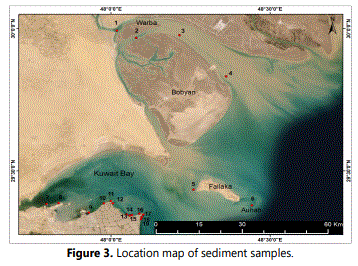
In the present study, 228 triplicate grab samples were collected from 19 stations include ports, marinas, and Islands shown in Figure (3). At each site, three replicates of four surface sediment samples were collected from the siteʼs corners by Van Veen grab sampler between March and June 2015. In the lab, surface sediment samples were air-dried in a hood. Samples were grounded and stored in clean glass containers in a dark place for further analysis.
Acetate buffer to methanol (CH3OH) was used to extract organotin compounds from sediment by adding 5% sodium tetraethyl borate (NaBEt4) and partitioned into n-hexane (David et al., 2003). One gram of air-dried samples, blank, or CRM added to a centrifuge tube, then added 10 ml of acetate buffer,7 ml of methanol, 4 ml of 5% NaBEt4, 10 ml of hexane, and 250 µl of 10 ppm internal standard. The extracted samples were shaken for 20 minutes then centrifuged for 10 minutes and the clear upper layer was used for TBT analysis. The results of organotin compounds in each station were added to the created GIS map for spatial interpolation in ArcMap software.
Result and Discussion
Organotin in sediment samples
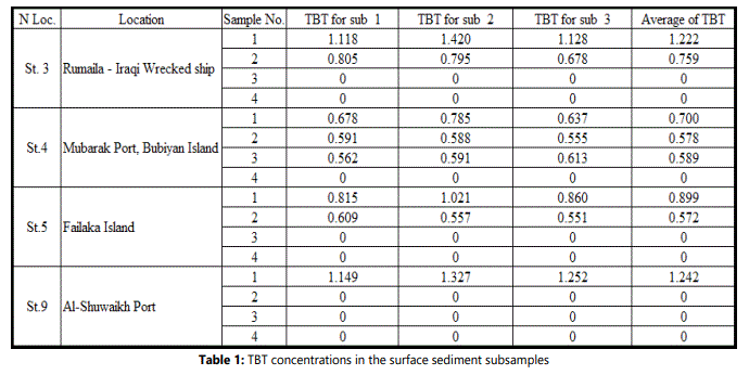
The results showed the presence of TBT in 9.5 % of the total surface sediment samples, three in the northern Kuwait and one in Kuwait Bay. Tributyletin (TBT) was detected in two of the four triplicate samples at Rumaila - shipwreck, three triplicate samples at Mubarak Port on Bubiyan Island, and two replicate samples at Failaka Island marina. In Al-Shuwaikh Port, the TBT was detected only in one of the four replicate samples at near the dry dock (Table 1, and Figures 4-7). The maximum TBT concentration detected was at 1.242 µg g-1dw at Al-Shuwaikh Port and the minimum was 0.572 µg g-1dw at Failaka Island.
Spatial interpolation of TBT in sediment samples
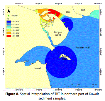
Inverse distance weighted (IDW) is a method for spatial interpolation in Arc map software. This tool assumes that the closest features have values which are more alike than the far features. IDW uses the average of the available measured values to predict the surrounding unknown values. In addition, the anonymous values that are close to the measured one are more influenced than the farther ones. Fig.8 shows the IDW interpolation output. Based on the sample readings, red color showed the high concentration of TBT around the sample location in Rumaila – Iraqi in the north. The dark blue showed the low distribution of TBT in Mubarak Port, Bubiyan Island and Failaka Island.
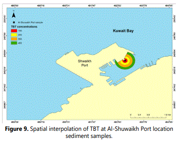
One of the spatial analysis tool in Arc map is the Buffer tool. This tool draws a polygon or a shape around the feature in certain distance. In Al-Shuwaikh Port case, a multi buffer with increased distances measured with meters were created to show different TBT concentrations from the sample location (Fig.9). The concentration is decreasing by moving away from the contaminate source location.
The potential sources of TBT in sediment samples
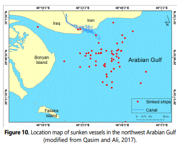
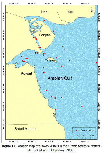
Iraqʼs coastline, from the north to the Arabian Gulf, was a 58-km stretch with five major ports and two deep-water ports and all located in the primary channel of the Khor Al-Zubair. Umm Qasr Port is the second Iraqi port on the western coast of the Al-Faw Peninsula and is separated from the Kuwaiti border by a small inlet. There were two dry docks in the Khor Al-Zubair, the first called Hittin, was a floating basin established in 1982 for the maintenance and services of small marine vessels, whereas the second called Al-Sawari, was a harmonic dry dock in Umm Qasr established in 2000 to maintain military vessels (Al-Asadi, 2005). A report published by the UN Development Programme, recognized 280 shipwrecks, 260 of which were commercial and 40 of these shipwrecks need immediate salvage (Valerie, 2005). The temporal satellite imagery showed many shipwrecks positioned in the Shatt AlArab estuary northwest Arabian Gulf mostly as a result of the Iraq-Iran War (1980 -1988), and in Khor Abdullah and Khor Al-Zubair as a result of both the Gulf War (1991) and the US invasion of Iraq (2003). At least 80 ships were attacked and remained as wrecks in the course of the main navigation channel or on the channel sides, which potentially threatened the marine environment due to leakage and / or spills of antifouling substances, petroleum products, unexploded ordnance, and possibly rocket fuel, propellants, and toxic chemicals (UNEP, 2003). At the entrance of Khor Abdullah in northwest Arabian Gulf, a total of 61 sunken vessels of different size were located (Fig. 10). After the Gulf War (1991), Kuwaiti ministry of communication identifies 34 sunken vessels of different size were located in Kuwaiti territorial waters a long off the Kuwaiti coast (Fig. 11). These sunken vessels represent a potential source of different pollutants including TBT may be transported toward the Kuwaiti territorial waters. Both petroleum and antifouling substances seem to be the main two critical problems posed by those and other shipwrecks. The temporal satellite imageries showed several petroleum shipwrecks near the territorial border between Kuwait and Iran, destroyed during the Iraq-Iran War. In the north, Khorramshahr and Abadan represented the largest ports in southern Iran, located at the south of the Shatt AlArab River. A total of 167 shipwrecks were positioned on the Iranian side; 92 petroleum tankers, 9 cargo ships and 66 other different kinds of vessels (Grimord, 1986; El-Shazly, 1998). These are additional sources of organotin compounds, transported by the Shatt Al-Arab discharge towards the Kuwaiti territorial waters.
According to Khalifa (2009), the flow and sedimentation loads decreased in the Shatt Al-Arab River due to many shipwrecks that act as barriers against the water flow and trapping sediments. The sedimentation reduced the depths of the Shatt Al-Arab River to shallow level that was not adequate for large ship navigation particularly on the Iraqi side, in addition to a great deal of petroleum spilled into the marine environment. These ships were sunk on the Iraqi and Iranian sides during 1980-1988, i.e., before TBT was banned in 2008, so that was most likely to be the source of TBT that potentially leaked into the marine environment, which possibly extended to uncontaminated areas. It was of great importance to initiate a regional survey to assess the levels and types of pollutants in the areas of these sunken ships.
Conclusions and Recommendations
Based on the findings obtained in the present study, the following conclusions were drawn and recommendations formulated. Organotin compounds (OTCs) found in 9.5% of the sediment samples were mostly at the northern coast associated with silt and fine silt textures (i.e.< 230.0 µm in diameter) as TBT instability occurred in TBT+, ion exchange between TBT and other chemicals at broken edges of such sediment texture provided the opportunity to trap organic pollutants. Sources of organotin were the sunken vessels scattered in the northwest Arabian Gulf for more than 20 years potentially contributing the antifouling compounds transported by the anti-clockwise current regime toward the Kuwaiti territorial waters. Another source was the transboundary effect of maintenance activities practiced in the dry docks of adjacent countries in the north formed another potential source of antifouling compounds transported by freshwater discharge. The current movement, characterized by high velocity particularly during the ebb cycle on the northern coast, provided the opportunity to wash out the surface pollutants accumulated on the bottom. However, the concentrations observed at inside sites as in Mubarak and Shuwaikh ports seemed to be less affected by the current movements. The shallow depths throughout Kuwaitʼs coasts (< 10 m during high tide), provided an opportunity for irradiation by ultraviolet sunlight to degrade the TBT concentrations adsorbed onto surface sediments by photoreaction despite the complexity of the bottom texture. The banning of TBT as a component of antifouling paint in Kuwait since 2008 obviously reflected on the marine environment, where the level observed was most likely to be of transboundary sources, beyond the territorial waters. So it is recommended to cooperate with neighboring countries on transboundary effects of potential pollutants to identify preventive and remedial actions to promote long-term sustainable development takes place in the region, which may extend to the Arabian Gulf as a whole.
References
- Aba A, Uddin S, Bahbahani M, Al-Ghadban A. Radiometric Dating of Sediment Records in Kuwaitʼs Marine Area. Journal of Radio analytical and Nuclear Chemistry. 2014; 301(1): 247-255. doi:10.1007/s10967-014-3140-z
- Al-Ghadban A.N. Assessment of suspended sediment in Kuwait Bay using Landsat and Spot image. Kuwait Journal of Science and Engineering. 2004; 31 (2): 155-172.
- Al-Ghadban AN, Abdali F, Massoud MS. Sedimentation rate and bioturbation in the Arabian Gulf. Environment International.1998; 24(1/2): 23-31. doi: 10.1016/S0160-4120(97)00118-9
- Al-Ghadban AN, Al-Yamani F, Al-Sammak A, et al. Environmental Stress of Kuwaitʼs Coastal Area Due to the 1991 Oil Slick. International Journal of Oceans and Oceanography. 2007; 2(1): 25-50.
- Al-Ghadban AN, El-Sammak A. Source, distribution and composition of suspended sediments, Kuwait Bay, Northern Arabian Gulf. Journal of Arid Environment. 2005; 60(4): 647-661. doi: 10.1016/j.jaridenv.2004.07.017
- Al-Sarawi MA. Surface geomorphology of Kuwait. Geo Journal. 1995; 35(4), 493-503.
- Hartmann M, Lange H, Seibold E, et al. Oberflachensedimente im Persischen Golf und Golf von Oman. I. Geologisch-hydrologischer Rahmen und erste sedimentologische Ergebnisse. Meteor Forsch. Ergebn. Gebruder Borntraeger, Berlin. (1971); 4: 1-76. doi: 10.1594/pangaea.548404
- Issa BM, Albadran BN, Al-Shahwan MF. Sedimentological and paleontological study of the tidal flat recent sediments of Khor Al-Zubair and Khor Abdullah, Northwest Arabian Gulf. Mesopotamian Journal of Marine Science. 2009; 24(2): 86-97.
- Khalaf FI, Al-Bakri D, Al-Ghadban A. Sedimentological characteristics of the surficial sediments of Kuwait marine environments, north Arabian Gulf. Sedimentology. 1984; 31(4): 531-545. doi: 10.1111/j.1365-3091.1984.tb01818.x
- Khalaf FI, Misak R, Al-Dousari A. Sedimentological and morphological characteristics of some nabkha deposits in the northern coast plain of Kuwait Arabia. Journal of Arid Environments. 1995; 29(3): 267-292. doi: 10.1016/S0140-1963(05)80107-7
- Reynolds RM. Physical Oceanography of the Gulf, Strait of Hormuz, and the Gulf of Oman- Results from the Mt. Mitchell expedition. Marine Pollution Bulletin. 1993; 27: 35-59. doi: 10.1016/0025-326X(93)90007-7
- UNEP Report. Environment in Iraq. UNEP Progress Report, 1- 44. 2003.
