

Research Article
Changes in Groundwater Levels and the Response of Natural Vegetation to Transfer of Water to the Karagachev Groves
American University of Central Asia, 7/6 Aaly Tokombaev Street, Bishkek, Kyrgyz Republic
*Corresponding author: Sagynbek Orunbaev, American University of Central Asia, Kyrgyz Republic, Email: kulenbekov_z@auca.kg
Received: September 14, 2021 Accepted: October 10, 2021 Published: October 19, 2021
Citation: Kulenbekov Z, Orunbaev S and Mamedov E. Changes in Groundwater Levels and the Response of Natural Vegetation to Transfer of Water to the Karagachev Groves. Int J Earth Sci Geol. 2021; 3(1): 100-104. doi: 10.18689/ijeg-1000113
Copyright: © 2021 The Author(s). This work is licensed under a Creative Commons Attribution 4.0 International License, which permits unrestricted use, distribution, and reproduction in any medium, provided the original work is properly cited.
Abstract
The importance of many geological processes occurring in nature strongly affects life around the world. One of them as a groundwater plays an important role in the development of geological processes such as liquefaction, flooding. This research work was needed to define a depth variation presence of groundwater in the area Karagachev groves, into which groundwater flow upper surface level, as this area is a low relief area of the city Bishkek. The research is relevant both in the study and analysis of the presence of underground water, as well as that contribute to the response of natural vegetation. In this part of the city a groundwater seasonally moves from areas of high hydraulic head to areas of low hydraulic head. Using Vertical Electric sounding method was carried out a depth of groundwater along the profile in Karagachev grove park. Identified results show that a depth variation within 0.5 m to 6-7 meters along the profile. Identified the depth of groundwater in the Karagachev grove close to the earthʼs surface that is saturated with water in the Bolshoi Chuy Canal (BCC), which become one of the future problems to reconstruction of BCC. Therefore, the research reveals the real potential of many factors that are important both ecologically and socially for conducting and solving many complex problems for the southern part of the city Bishkek.
Keywords: Groundwater, water supply, vertical electrical sounding.
Introduction
By the concept of underground waters are minted all types of water located in pores and cracks of rocks. Most groundwater is widespread in the Earthʼs crust, and the study of them is of great importance in solving issues: water supply to settlements and industrial enterprises, hydraulic engineering, industrial and resort-sanatorium business, etc. Geological activities of groundwater have extensive topics now of the relevance of study and research. Karst processes in soluble rocks, destruction of mineral deposits and formation of them in new places are connecting with underground waters. Therefore, mostly groundwater and its origin, distribution, movements underground, are the subject of study of special science - such as hydrogeology, one of the branches of geology [1].
The purpose of the study is identifying the level of the groundwater along the profile in the Karagachev Grove Park. The level of groundwater in this part of the city seasonally very high, almost close to the surface -0.5 to 1.0 m [10]. This kind of seasonal variation very dangerous to soil liquefaction process during earthquake. Multi-floor buildings by the Government prohibited to construct in the Northern part of the city by building code (SNiP), due to liquefaction factor might be large damages, losses after an earthquake [15].
Area of Study
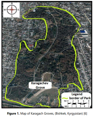
The Karagach grove is located in the lower reaches of the city of Bishkek and below the Great Chuy Canal since groundwater seeps into the ground during the melting of glaciers and flows and accumulates in the lowlands. This part of the city was chosen for the study because it has great potential for access to groundwater resources (fig. 1).
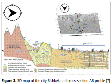
In the current study, the whole prospect of the research is concentrated on field work in order to use instrumental measurements and clearly fix an accumulation of groundwater and its moving to the lowlands. The basis of many studies [2,3,4,5 and 14] shows the multiple angles of its support in the field of hydrogeological processes, such as the basis of the permeability of water-related substances that flow under urban landscapes. Subsequently, the melting of glaciers that seep through permeable rocks and have an important response in how many waters move in one direction and accumulate in one place and have a long and complex objective significance of the study. Therefore, this study gave us an analytical approach to investigate soils that are an important material or barrier that holds water resources and gives multiple distributions in the Karagachev Grove zone. Underground water is formed during the melting of glaciers in the mountains, after the melting of glaciers, a liquid is formed that goes underground. Based on this definition of groundwater formation was built detail map of the city of Bishkek using data from the satellite Shuttle Radar Topographic Mission (SRTM), which has an accurate, high resolution 30-meter DEM-data (Figure 2). An important source of those resources formed in the aftermath of groundwater that move underground accumulating in one area.
The research study consists into a few important parts, which throughout the study reveal the validity of the data studied that are available in the database and their statistical analysis.
Methodology
Methodology of the study of groundwater has a complex and time-consuming way of analysis. Everything clearly reveals the method of investigation and obtaining a more specific analytical solution, and programs that have the prospects of disclosing this study.
During the field work as much data as possible obtained by the method of vertical electric sounding. All the main research topics are aim at concluding that how underground water and the concentration of their salts in the zone of our study are useful for supplying the vegetation of this zone. The subject matter of this study itself is complex and confusing, but it has an interesting main answer: how cans a person uses groundwater in the Karagachev Grove zone to irrigate vegetation and supply water resources to other areas of the grove [8].
The study of groundwater is extremely important for various sectors of the economy which is the foundation of many processes. Groundwater is an important factor in the main supply of rivers; it is of exceptional importance for living organisms; it is of great practical importance in the water supply of settlements, etc. The basis of methods for studying groundwater is a system of Electric exploration of soil structures. Basically, at the moment, a more relevant method for studying groundwater is Vertical Electric Sensing. At the moment, electric probing remains one of the most widely used electric exploration methods.
As an equipment to measure a groundwater level Land Mapper, ERM-01 and ERM-02 Geophysical Instruments were used, measured an electrical resistivity and conductivity within soil, as well as natural electrical potentials [9].
Therefore, based on data collection and a research approach, the most important procedures for effective analytical viewing of many data shown through the Res1D program, designed to double-interpret VES data for a two-dimensional observation profile.
Results
During the fieldwork carried out for study, the main attention was paid to the important advantages of the availability of groundwater in the Karagachev Grove area. Many factors were revealed that showed how groundwater seeping into the soil during the melting of glaciers, and how they had the prospect of moving under the city of Bishkek and accumulated in one place. The basis of much field work shows significant studies of many factors about the presence of groundwater in the Karagachev grove zone, which is a related issue in the decisive approach of the analytical review [1].
Depending on the research approach, the most important procedures for the efficient analytical viewing of many data through the IPI2Win program, which is designed for one-dimensional interpretation of VES data for one observation profile, are shown. Many of the information in this study clearly and specifically describe and review the most important strategic plans to which our State turns a blind eye. The fact is that when glaciers melt, this has the right natural relationship in the process of obtaining drinking water, which is very important to get artesian water when drilling wells [2].
The first result was obtained in this study of the study of the map and how groundwater flows from the mountains to the lowlands of the relief city of Bishkek. As a result of the obtained map with the GMT program, there was the prospect of the data obtained in relation to many considerations, the data that built the map and the path of the flow of groundwater towards the borders with Kazakhstan. Figure 2 shows a map obtained by the GMT geographic information system, which is systematized with an indication of the path of groundwater to the cluster area in the Karagachev grove zone. The map obtained by the geographical information system has two objects on figure 3, one of which is a map of the city of Bishkek and its districts below the border, and the second object is a graph of the descent from the sides of the mountain in the lowlands of the city of Bishkek. The graphical representation of the data when studying the Bishkek map from the mountains has great potential as an open research point, which in this study must be with an important understanding of a single combination of data.
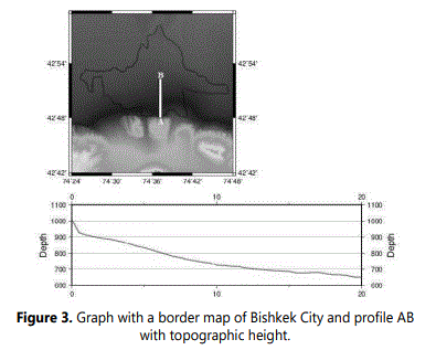
Therefore, the description of this kind of data may seem more complicated, but in a nutshell you can find two important things. What is the relevance of this schedule and how it has serious consequences in the study of many factors, the resolution in this region into which the regions of the Karagachev grove were derived. The importance of this graph shows how the main topic of the study is the topic of the presence of groundwater in the Karagachev Grove in large quantities, and how the movement of water and its accumulation in the lowlands of Bishkek is the basis of many insoluble discussions [10].
The graphs obtained by reconnaissance data used by the program IPI2WIN also have an important analytical track for many studies in the Karagachev Grove area. Figure 4 (a, b, and c) show graphs that were identified for the three summer months of June, July, and August.
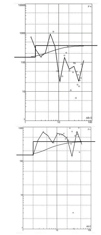
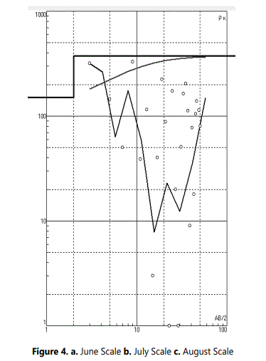
Research data from the summer period and in the region had great potential for warming and high temperatures, which contributed to large losses of melting glaciers in the mountains. Figure 4a shows a graph of the month of June, the main basis of the analysis shows how high the permeability is based on the high data that is presented on the graph; of the current obtained, by the electrical exploration, of Vertical Electric Sounding.
According to the data obtained during the fieldwork, the permeability of the current had a great development potential, which showed how it was possible to use this inflow of water that accumulated and flowed from the Karagachev Grove to the borders of Kazakhstan. In this study, vertical electrical sensing had a 100-meter distance profile of water permeability through rocks and had high analysis scores. The analytical basis summed up in the study about the presence of large amounts of groundwater volume gives a lot of experience in the disclosure of many natural factors that occur in the circular process of many relationships. This is done by the appearance of a graphical representation as an ordinary method of the basis of many relative geophysical distributions of groundwater analysis in the study area. Therefore, based on the planning of graphic data, we come to the fact that the first month of the summer had both complex and very favorable volumes of groundwater availability.
The second month of the summer of July, compared with the data of the previous month, the even larger basis of the shocks in the graphical representation had important bases for the interpretation of the presence of underground water and their number also has a high potential for the well-being of the entire study area.The basis of the study of the systematic validity of the data for the month of July should take into account the importance of many factors that are associated with natural melting of glaciers in the environment. The high temperature of the city of Bishkek in these months, especially in the month of July, had a higher relativity of the legal ratios of the analytical data result. Therefore, based on natural factors, it is also necessary to take into account that there is underground water in which large quantities of underground water are moving accumulating in the zones and areas of the Karagachev Grove.
The last month of summer, received results in August explained lower indicators of groundwater volumes compared to the previous months, which suggests that in the autumn the water level below the soil flow remained in the lowlands due to lower permeability, which shown in the graph (Figure 4c) [7].
Therefore based on the above we will conclude from the results that in two months the flow of groundwater accumulated enough in huge quantities which suggests that the availability of volumes depends on the season and time of study of the region. Based on this underground water moves at a high speed which leads to many factors that occur naturally in the mountains and the generated water flows down the urban terrain to areas of lower slope such as below the river zones of the Karagacheva Grove. Groundwater and soils form a single dynamic interconnected system, they largely determine the development of geological processes that occur naturally – the third main component of the geological environment [12].
The flow of groundwater mainly depends on the terrain, so in our case, the graphs shown on the map and the location of the urban landscape, which increasingly has a slope in which it has the potential of groundwater flow in the direction of the Karagacheva grove. The free flow of water leads to a decrease in the level of groundwater within the depression that showed us the results of the last month in August.
Conclusion
The essence of the relevance of this topic of research is the basis of how the state can use the data for good deeds for drilling wells, and so in the lowlands of the city of Bishkek, water accumulates in large volumes, but at the same time, it flows to the neighboring territory of Kazakhstan. And this indicates what kind of favorable needs of nature at the same time Kyrgyzstan loses from its own territory during the drainage of groundwater through the territory of Bishkek, which is an economically disadvantageous role in examining the situation in the region. Also, the water that flows into these zones has great potential for both irrigation and artesian water well drilling, which also has a high potential for studying from an economic point of view. Basically, the Karagachev grove is a park in which there is a sufficient amount of vegetation, so for them to be watered without pulling pipes into these zones, you can have the opportunity to build borehole pipes for watering the vegetation in this zone [13].
Recommendation
As everyone knows, Kyrgyzstan is the second country after Russia in the post-Soviet space with large volumes of clean drinking water. In this study, we addressed the importance of irrigation of the vegetation of the Park Karagach grove. How much the importance of this letter is a more effective basis for resolving conflicts based on the use of natural resources is an important priority of peace and harmony. But an important tactic of research and disclosure of the rules of uniform use of water leaves an important trace on the papers and documentation of the development of many factors in nature as a whole. Therefore, this topic is more thorough disclosure of many studies in the field of hydrogeology about the right to use water that is located underground by pumping out drilling wells. Based on the analytical solution, I think that the potential for studying groundwater is at the stage of extinction, so it would be possible to Finance several projects in this course of Affairs, the importance of which is based on the use of water in all spheres of humanity.
References
- Burgaard S. Groundwater and Surface Water Connections. Natural Resources & Environment. 2016; 31(1): 54-55.
- Daly D. Groundwater—The ‘Hidden Resourceʼ. Biology and Environment: Proceedings of the Royal Irish Academy. 2009; 109B(3): 221-236.
- Ohgaki S, Takizawa S, Kataoka Y, et al. Sustainable Groundwater Management in Asian Cities. Institute for Global Environmental Strategies. 2007; 19-24.
- Morris BL, Darling WG, Gooddy DC, et al. Assessing the extent of induced leakage to an urban aquifer using environmental tracers: an example from Bishkek, capital of Kyrgyzstan, Central Asia. Hydrogeology Journal. 2006; 14(1): 225–243. doi:10.1007/s10040-005-0441-x
- Orunbaev S, Asanov B, Kulenbekov Zh. Groundwater Flooding Risk Assessment Using Microseismic Arrays and VES Techniques in the Northern Part of Bishkek. Water Resource Management in Central Asia and Afghanistan. 2021; 93-105. doi: 10.1007/978-3-030-68337-5_10
- Litvak R G, Nemaltseva E I, Tolstikhin G M. Chapter 17 - Groundwater Environment in Bishkek, Kyrgyzstan. Groundwater Environment in Asian Cities. 2016; 383–412. doi:10.1016/B978-0-12-803166-7.00017-9
- Frenken K. Irrigation in Central Asia in Figures : AQUASTAT Survey – 2012. Food and Agriculture Organization of the United Nations (FAO). 2013. doi:10.13140/RG.2.1.2770.8247
- Environmental Performance Reviews. Kyrgyzstan: 2nd Review. United Nations (2009). United Nations Publications
- L E Orolbaeva. Technogenic Transformations of the Hydrogeosphere of the Kyrgyz Republic. News of the Ural State Mining University. 2018; 4(52): 68. doi:10.21440/2307-2091-2018-4-68-73
- Shrestha S, Pandey V P, Shivajoti B R, et al. Groundwater Environment in Asian Cities : Concepts, Methods and Case Studies. ButterworthHeinemann. 2016.
- Building Standards Of The Kyrgyz Republic SN KR 30-01: 2020 “Planning And Development Of Cities And Localities Of The Urban Type” (approved and put into effect by the order of the State Agency for Architecture, Construction and Housing and Utilities under the Government of the Kyrgyz Republic dated March 24, 2020 No. 39 –npa)
