

Opinion Article
Evolution of the Quaternary Topography of the Eastern Issyk-Kul Region (Kyrgyz Tien Shan)
1American University of Central Asia, 7/6 Aaly Tokombaev Street, Bishkek, Kyrgyz Republic
2Institute of Seismology, National Academy of Science Kyrgyz Republic, Asanbay 52/1 Bishkek, Kyrgyz Republic
*Corresponding author: Ormukov Cholponbek, American University of Central Asia, Kyrgyz Republic, Email: ormukov_ch@auca.kg
Received: September 11, 2021 Accepted: September 29, 2021 Published: October 06, 2021
Citation: Cholponbek O, Erkin R, Zheenbek K. Evolution of the Quaternary Topography of the Eastern Issyk-Kul Region (Kyrgyz Tien Shan). Int J Earth Sci Geol. 2021; 3(1): 93-99. doi: 10.18689/ijeg-1000112
Copyright: © 2021 The Author(s). This work is licensed under a Creative Commons Attribution 4.0 International License, which permits unrestricted use, distribution, and reproduction in any medium, provided the original work is properly cited.
Abstract
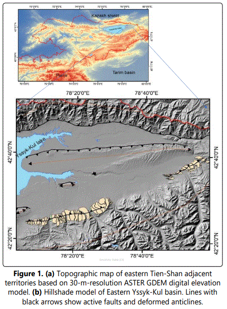
The Issyk-Kul depression, slightly resembling an inverted triangle, extends from west to east for more than 220 km, and the maximum width reaches 75 km in its central part. Tilted river and lake terraces in deformed structures in the eastern part of the IssykKul basin are the result of active tectonic movements in the Quaternary time. In this research, we focused on the evolution of topography with the goal of defining the features of active tectonics, through the analysis of the digital elevation model (DEM). The belt of modern deformations in the eastern part of the basin extends in the latitudinal direction for more than 80 km. In this area from west to east, there are several separate anticlinal structures composed of Paleogene-Neogene and Quaternary deposits. Geological-geomorphological mapping and profiling of terraces show that the deformation of the terraces is caused mainly by gently dipping thrust faults. Active faults are represented in relatively small segments of 10-20 km, with the exception of the Tasma fault. This fault, extending to the west for more than 60 km, deforming a broad lake terrace at an elevation of 1650 m. Analysis of the terraces shows that the older (Q2) terraces occupying the foothill zones have relatively steep slopes and in some places their surface is also ruptured with modern active faults. Late Pleistocene and Holocene terraces completely occupy the entire flat part of the basin, and in some places, these terraces also underwent deformation. The degree of influence of tectonic and climatic processes on the evolution of the Quaternary topography is preserved in the morphometric characteristics of river and lake terraces. The development of deformation processes inside the basin in this region with a width of 40–45 km is the result of active shortening of the earthʼs crust, which is caused by the counter movements of the Teskey and Kungey ranges.
Keywords: Tectonics; active faults; terraces; anticline; yssyk-kul; morines, quaternary time; aspect; climate.
Introduction
The uplifted mountain ranges and plateaus are the result of long-term geodynamic processes that raised rocks to the surface of the Earth, submerged at a depth of tens and hundreds of kilometers. Against internal processes, exogenous processes for a long time in parallel participated in the demolition of higher hypsometric areas, thereby; transporting materials filled the underlying territories. Thus, the relief is the result of the interaction of tectonic and erosional processes caused by the climate on geological time scales. (Molnar et al., 1994, 2010; Kirby et al., 2000; Hancock and Anderson, 2002; Clark et al., 2005; Bookhagen, B, and D. Burbank 2006; Liu-Zeng et al., 2008; Pan et al., 2009; Ouimet et al., 2010; Perrineau et al., 2011; Burbank, Douglas W. and Anderson, Robert S. 2011; Champagnac, J.-D., 2011; Finnegan et al., 2014; Y. Yang et al. 2019).
The age of the Tien-Shan according to thermochronological and paleomagnetic data is from 10 up to 25 Ma (Bullen et al., 2001, 2003; Sobel et al., 2006 a, 2006 b). Modern active structures located within the intermountain basins indicate crustal shortening in the Tien-Shan over Pleistocene and Holocene times (Ghose et al., 1998; Mellors et al., 1997; Reigber et al., 2001; Abdrakhmatov et al., 1996; Zubovich et al., 2010; Thompson et al., 2002; Selander et al., 2012; Goode et al 2014).
The interrelation of tectonic and climatic processes in the Quaternary time in the eastern part of the Issyk-Kul depression is well reflected in the modern relief of this region. Quaternary terraces and young tectonic structures are the main landforms and, in general, indicate the intensive development of topography during the indicated time. Primary paleogeographic studies for this area were actively carried out in the period 1950-1990. These works, in particular, considered a complex of issues of geomorphology, stratigraphy and tectonics, and also on the absolute dating of lake terraces (Popov., 1960; Grigorenko.,1970; Aleshinskaya et al., 1971; Zabirov et al., 1973; Trofimov., 1990). The relationship of lake and river terraces, as well as periods of transgression and regression of the lake. Issyk-Kul is considered in detail in the later works of the authors who give exhaustive answers about the Late Quaternary and Holocene palegeography of the region. (Dan Bowman et el., 2004; R.J. Burgette et al 2017; M. D. Batist et al., 2013).
Methods
Field work
Field work was carried out in the eastern part of the IssykKul depression, in particular in the river valleys, Turgen and BozUchuk. This allowed us to study the relationship between glacial and terraced deposits in the Turgen valley and trace the relationship with lake terraces. Moraines, fan cones, terraces were surveyed and mapped using standard techniques and remote sensing. Geological and geomorphological mapping allowed us a spatial analysis of the distribution of Quaternary forms and sediments with special attention to fluvial terraces, which allows us to obtain a chronology of successive landscape changes in river flows in the eastern part of the Issyk-Kul region.
Remote sensing
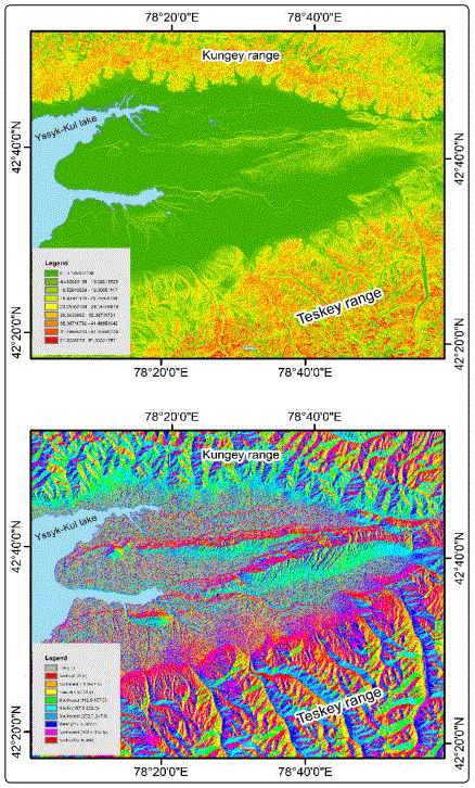
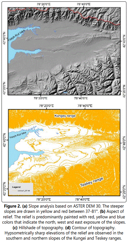
The ASTER GDEM 30m Digital Terrain Model was analyzed in detail using remote sensing. On the basis of the DEM, a geological map of the study area was created. For the purpose of geomorphological analysis using DEM and GIS technology, we modeled the stronity of slopes and their exposure. To analyze the erosion of streams in the mountainous area and in the depression, we also used remote profiling (longitudinal profile) along the main river beds.
Study area
Geological setting 3.1.: The sides of the depression are composed of pre-Riphean, Proterozoic and Paleozoic deep metamorphic, sedimentary and igneous rocks, which quickly sink to a considerable depth - up to - 4.5 km (Chedia et al., 1978) and give way to younger formations. Metamorphic ancient sedimentary strata are represented by rocks of the Proterozoic, Lower Silurisy, Lower and Middle Carboniferous age. These are mainly crystalline schists, quartzites, limestones and sandstones. Large areas (within the mountain frame) are also occupied by granite intrusions.
Among the Mesozoic-Cenozoic formations, two complexes are distinguished: the terrigenous continental, corresponding to the platform stage of the development of the studied territory in the Mesozoic and Paleogene, and the molasse, formed in the recent orogenic stage during the Late Paleogene, Neogene and Pleistocene. Young Paleogene-Neogene and Quaternary sediments filled the synclinal part of the depression (fig.3).
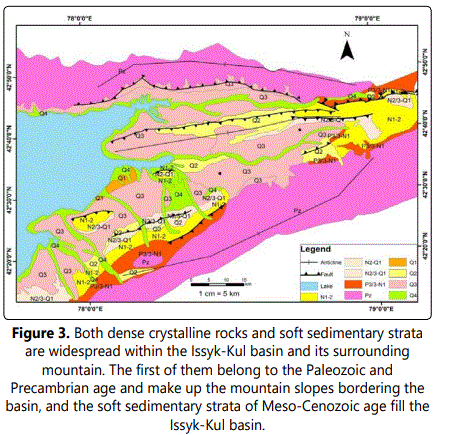
Younger Quaternary sediments periodically filled the depression with varying intensity. Judging by the thickness of the deposits, the depression with boulder-pebbles was actively filled from the Middle Quaternary to the beginning of the Holocene after each glaciation.
Active faults 3.2.: Active faults of the Issyk-Kul depression deform young Quaternary surfaces with intense folding, which are expressed here both as separate isolated anticlinal structures, and as a forerun zone of the Teskey range. The average absolute hypsometric position of active structures is 1800-2200 m. The base of these structures consists of Paleogene-Neogene sediments, which conformally overlapped bedrock deposits before the onset of deformation. Active faults here, as in the rest of the Tien Shan regions, are of thrust type and extend parallel to the main anticlinal structures. (Makarov 1977; Abdrakhmatov et al., 2001; Thompson et al., 2002; Selander et al., 2012; Goode et al., 2014).
The rate of reduction in the eastern part of the Issyk-Kul depression is one of the highest in the territory of the Kyrgyz Tien Shan. According to GPS measurements, the rate of decline in the last two decades has varied from 2 to 3 mm / year in the western part of the basin to 4-5 mm in the eastern part of the basin. (Zubovich et el., 2010).
If the active faults along the Teskey Range are south vergent, then the Tasma anticline and other structures located inside the depression have the opposite vergence. The zone of active deformations mainly covers the Middle Quaternary and Late Pleistocene terraces. In the foothills of the Teskey Range, the surface of deformed terraces is inclined to the north at an angle of 7-9 °. The inner part, in particular, the edge of the lake terraces of the Tasma ridge is inclined in the form of narrow surfaces in the opposite direction. Thus, the role of the tectonic activity of the region along with climatic factors in the formation and development of topography in the Quaternary was great.
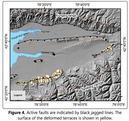
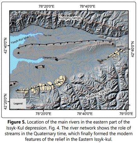
Terraces 3.3.: The river network of the region is represented by such rivers as Karakol, Ak-Suu, Altyn-Arashan, Zherges, Boz-Uchuk, Turgen, Jergalan, and also the Tyup river and its tributaries flowing down the southern slopes of the Kungei ridge. These rivers played a colossal role in shaping the relief of the study area. The valleys of the above rivers mainly consist of deeply cut V-shaped valleys (figure 5).
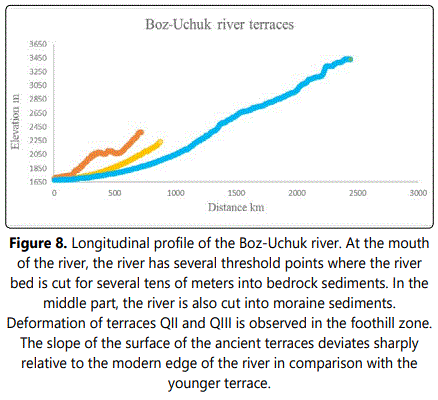
The role of climate in the formation of the relief in the Issyk-Kul depression is very great and the forms of relief created by the influence of the climate in the Quaternary time occupy the foundations of modern landscapes. Extensive terrace complexes in the eastern part of the Issyk-Kul depression formed in the Middle and Late Quaternary (Trofimov 1990; Aleshinsckaya et al., 1971). Series or steps of terraces correspond to large erosional-accumulative stages in the Issyk-Kul depression. In each valley and even in specific parts of the valley, the number of terraces may be different. This is due to the complexity of the structural-tectonic plan, the differentiated nature of the Quaternary movements. Due to the subsequent tectonic deformations, the comparison of terraces in different valleys and in different parts of the valleys is extremely difficult. This circumstance is aggravated by the inconstancy of the basis of the level of erosion of the lake. Issyk-Kul. When studying terrace complexes, we relied on the scheme of Grigorenko, who developed a paleogeographic structure for the development of terraces for the Tien Shan. (figure 6).
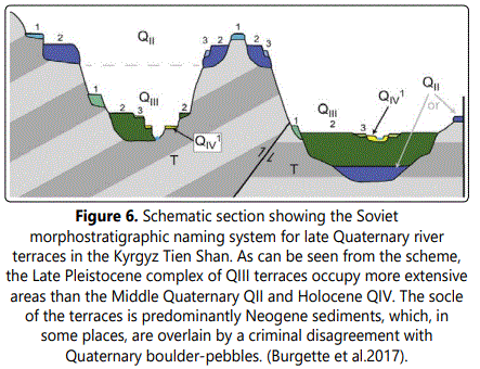
In the Quaternary period, the rivers were deeply cut into the underlying rocks, and at present they are preserved in the relef in two morphotype forms, alluvial and basement. If the alluvial terraces are closer to the channel with thick deposits, then the basement ones occupy more hanging positions and were separated from the channel with subsequent erosion. If, in the first case, active tectonic events influenced the modern morphrometric position, then the Holocene development of the terraces was influenced by the beginning climatic changes at the beginning of the Holocene and subsequent times.
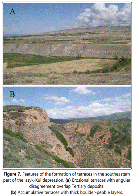
Terraces of an accumulative nature, when leaving the Teskey and Kungey ridges, form alluvial cones. The thickness of boulder-gelled deposits reaches from 5 to 50 meters and in some places they overlap the Tertiary deposits with angular unconformity (fig. 5). Erosion of the rivers along the northern and southern slopes of the Teskey and Kungey ranges, as seen from the profile, have a rather steep slope, which is cut into bedrock and looser (fluvioglacial deposits) deposits (fig. 6). The steepness of the river channels gradually decreases towards the depression.
Oscillation of the lake also played an important role in the development of river valleys. Issyk-Kul, since its transgression and regression regimes completely controlled the rate of erosion of the channels of outflowing rivers.
3.4. Moraines: Moraine deposits in the valley of the Turgen River are located above 2600 m. The features of the ancient glacial relief are perfectly expressed here.
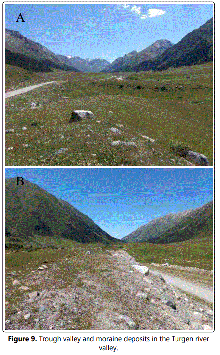
The troughs of the main valleys have wide bottoms and gently sloping sides. The well-developed trough valley of the river is especially characteristic. Turgen, the bottom of which is 1 km wide. On the surface of the bottom of the valley, the ancient moraine relief has been preserved in the form of randomly scattered hills stretching for 2.5-3 km along its entire width.
The valleys of most of the tributaries do not have high estuarine steps. The troughs of the tributaries are extensive, their sides are flat, the slopes are densely sodded. Fresh talus appears only in the upper reaches of the river. Turgen and its tributaries. The well-developed trough valley of this river, the consistency of the troughs of the tributaries and the main valley, the good preservation of the forms of glacial erosion, the presence of extensive cirques and walls - all this indicates the absence of intense erosion processes in the interglacial and the superposition of the glacial forms of the second phase of glaciation on the glacial forms of the first phase (Rantsman, 1957).
In other river valleys, moraine deposits have smaller areas of distribution. This was apparently due to the morphometric characteristics of individual valleys, where moraine deposits could not spread in less wide valleys.
Thus, in the relief of the mountains of the eastern part of the northern slope of the ridge. Teskey-Alatau, the effect of post-glacial erosion is pronounced and there are no traces of the action of interglacial erosion processes. The main deepening of the valleys apparently took place in the pre-glacial time. In the middle, the moraines of the last glaciation descended on average to 2200 m.
Discussion
An analysis of the topography shows that, in the Quaternary, the features of the formation of the landscape of the Issyk-Kul depression were closely related to tectonic and climatic factors. However, it is difficult to single out the dominant role of any factor in the formation of the entire landscape. For more than 1.8 Ma, tectonic and climatic events in the spatio-temporal relation obviously did not spread evenly. This is evidenced by the morphometric features of the modern relief of the region.
It should be noted about the role of fluctuations in the lake. Issyk-Kul, which significantly influenced the development of the depression relief. Intensive tectonic movements in the Early Quaternary and Middle Quaternary may have intensified the erosional activity of the rivers, which was also facilitated by the low level position of Lake Issyk-Kul. The thickness of the sediments also differs and is not so great, for example, from the same Late Pleistocene time.
Thus, glaciation and interglacial time as a whole formed moraine and terraced complexes in the hypsometric higher and lower regions, respectively. If we take in more detail what types of climate regimes, arid-cold or warm-humid, how they influenced the development of the relief in a specific section of the study area, in general, requires more detailed research.
Conclusion
Geological and geomorphological mapping based on the DEM and additional modeling by extracting some parameters of the DEM allowed us to obtain the main important geomorphological characteristics of the study area.
The slopes and their exposures show that the deformed tectonic structures have an asymmetric structure. Tectonic structures in the piedmont part of the Teskey Range are composed of longer northern and short southern wings. The large anticlinal structure Tasma is developing in the opposite direction, i.e. it has a meek northern and long back wings. Thus, the modern reduction of the earthʼs crust in the eastern part of the Issyk-Kul depression occurs in the southern and northern directions, involving the flat surfaces.
The longitudinal profile of rivers in the river valleys of the Teskey Range shows an uneven dissection of valleys with erosion processes. The rivers located in the eastern part stretch on average 30-35 km. Erosion processes in some rivers developed more intensively than some, as evidenced by the slopes of river channels with steeper profiles. Relatively gentle slopes have been preserved mainly where moraine deposits are more concentrated in the middle reaches of rivers. Thus, the scale of moraines, in spite of their loose state, significantly influenced the development of erosion processes after the Late Quaternary glaciation.
The terraces of this area are mainly represented by QIII accumulative terraces that filled large areas with a thickness of several tens of meters. These terraces also correlate well with the lake terraces at 1640 m.
Holocene accumulative terraces are located at 1620 m. Late Pleistocene terraces are located at 1630 m, 1640 m, and 1660 m. This suggests that after the Late Pleistocene period, due to the abundant melting of glaciers, the fluctuations in the level of Lake Issyk-Kul increased to the maximum.
Deep incisions of Late Pleistocene terraces can be practically seen in all river valleys around the lake. Issyk-Kul indicates that in the Holocene, with a decrease in the flow, the level of Lake Issyk-Kul which simultaneously caused deep erosion of rivers.
References
- K Ye Abdrakhmatov, S A Aldazhanov, B H Hager, et al. Relatively recent construction of the Tien Shan inferred from GPS measurements of present- day crustal deformation rates. Nature. 1996; 384: 450–453.
- Atkinson G M, W Silva. An empirical study of earthquake source spectra for California earthquakes. Bulletin of the Seismological Society of America. 1997.
- Dan Bowman, Andrey Korjenkov, Naomi Porat. Late-Pleistocene seismites from Lake Issyk-Kul, the Tien Shan range, Kyrghyzstan. Sedimentary Geology. 2004; 163(3-4): 211-228. doi:10.1016/S0037-0738(03)00194-5
- Klerkx J, Imanackunov B. Lake Issyk-Kul: Its Natural Environment. Kluwer Academic Publishers, Dordrecht.
- Bullen M E, D W Burbank, J I Garver, K Y Abdrakmatov. Late Cenozoic tectonic evolution of the northwestern Tien Shan: New age estimates for the initiation of mountain building. Geol Soc Am Bull. 2001; 113(12): 1544–1559.
- Bullen ME, D W Burbank, J I Garver. Building the northern Tien Shan: Integrated thermal, structural, and topographic constraints. J Geol. 2003; 111: 149-165.
- Bookhagen B, D Burbank. Topography, relief, and TRMM-derived rainfall variations along the Himalaya. Geophys Res Lett. 2006; 33: L08405. doi: 10.1029/2006GL026037
- Burbank Douglas W, Anderson Robert S. Tectonic Geomorphology. 2nd Edition. Hoboken, NJ: Wiley- Blackwell. 2011.
- Burgette Reed J, Ray J Weldon II, Kanatbek Ye Abdrakhmatov, et al. Timing and process of river and lake terrace formation in the Kyrgyz Tien Shan. Quaternary Science Reviews. 2017; 159: 15-34. doi: 10.1016/j.quascirev.2017.01.003
- Champagnac JD, P Molnar, C Sue, F Herman. Tectonics, climate, and mountain topography. J Geophys Res. 2012; 117: B02403. doi:10.1029/2011JB008348
- Clark MK, House MA, Royden LH, et al. Late Cenozoic uplift of southeastern Tibet. Geology. 2005; 33(6): 525-528. doi: 10.1130/G21265.1
- Finnegan NJ, Schumer R, Finnegan S. A signature of transience in bedrock river incision rates over timescales of 104-107 years. Nature. 2014; 505(7483): 391-4. doi: 10.1038/nature12913
- Goode J K, D W Burbank, C Ormukov. Pliocene-Pleistocene initiation, style, and sequencing of deformation in the central Tien Shan. Tectonics. 2014; 33: 464-484. doi:10.1002/2013TC003394 2014
- Ghose S, M W Hamburger, J Virieux. Three-dimensional velocity structure and earthquake locations beneath the northern Tien Shan of Kyrgyzstan, central Asia. J Geophys Res. 1998; 103: 2725–2748. doi: 10.1029/97JB01798
- Hancock GS, Anderson RS. Numerical modeling of fluvial strathterrace formation in response to oscillating climate. Geol Soc Am Bull. 2002; 114: 1131-1142.
- Liu-Zeng J, Tapponnier P, Gaudemer Y, Ding L. Quantifying landscape differences across the Tibetan plateau: implications for topographic relief evolution. J Geophys Res. 2008; 113: F04018. doi: 10.1029/2007JF000897
- Mellors RJ, FL Vernohn, GL Pavlis, et al. The Ms = 7.3 1992 Suusamyr, Kyrgyzstan earthquake: 1. Constraints on fault geometry and source parameters based on aftershocks and body wave modeling. Bull. Seismo. Soc. Am. 1997. 87 (1): 11–22. doi: 10.1785/BSSA0870010011
- Molnar P, Boos WR, Battisti DS. Orographic controls on climate and paleoclimate of Asia: Thermal and mechanical roles for the Tibetan plateau. Annu Rev Earth Planet Sci. 2010; 38: 77-102. doi: 10.1146/annurev-earth-040809-152456
- Molnar P, Brown ET, Burchfiel BC, et al. Quaternary climate change and the formation of river terraces across growing anticlines on the north Flank of the Tien Shan. China J Geol. 1994; 102: 583-602. doi: 10.1086/629700
- Ouimet W, K Whipple, L Royden, et al. Regional incision of the eastern margin of the Tibetan Plateau. Lithosphere. 2010; 2: 50-63. doi: 10.1130/L57.1
- Pan B, Su H, Hu Z, et al. Evaluating the role of climate and tectonics during non-steady incision of the Yellow River: evidence from a 1.24 Ma terrace record near Lanzhou China. Quat Sci Rev. 2009; 28: 3281-3290. doi: 10.1016/j.quascirev.2009.09.003
- Perrineau A, Van der Woerd J, Gaudemer Y, et al. Incision rate of the Yellow River in Northeastern Tibet constrained by 10Be and 26Al cosmogenic isotope dating of fluvial terraces: implications for catchment evolution and plateau building. Geol Soc Lond Spec Publ. 2011; 353: 189-219.
- Reigber C, G W Michel, R Galas, et al. New space geodetic constraints on the distribution of deformation in Central Asia. Earth Planet Sci Lett. 2001; 191: 157–165.
- Selander J, M Oskin, C Ormukov, et al. Inherited strike-slip faults as an origin for basement-cored uplifts: Example of the Kungey and Zailiskey ranges, northern Tian Shan. Tectonics. 2012; 31: TC4026. doi:10.1029/2011TC003002
- Sobel E R, J Chen, R V Heermance. Late Oligocene-Early Miocene initiation of shortening in the Southwestern Chinese Tian Shan: Implications for Neogene shortening rate variations. Earth Planet Sci Lett. 2006; 247: 70–81.
- Sobel E R, M Oskin, D W Burbank, et al. Exhumation of basement-cored uplifts: Example of the Kyrgyz Range quantified with apatite fissiontrack thermochronology. Tectonics. 2006; 25: TC2008. doi:10.1029/2005TC001809
- Thompson SC, R Weldon, CM Rubin, et al. Late Quaternary slip rates across the central Tien Shan, Kyrgyzstan, central Asia. J Geophys Res. 2002; 107(B9): 2203. doi:10.1029/2001JB000596
- Ye Yang, Cong-Qiang Liu, Jerome Van der Woerd, et al. New constraints on the late Quaternary landscape evolution of the eastern Tibetan Plateau from 10Be and 26Al in-situ cosmogenic nuclides. Quaternary Science Reviews. 2019; 220: 244-262.
- Zubovich AV, Wang X, Scherba YG, et al. GPS velocity field for the Tien Shan and surrounding regions. Tectonics. 2010; 23(6). doi: 10.1029/2010TC002772
