

Opinion Article
An Analytical Approach to understand the Tethys Sea and its possible effects on the Surrounding Landmasses
Applied Geology, Jadavpur University, India
*Corresponding author: Zarin Ali, Applied Geology, Jadavpur University, India, E-mail: zarinali95@gmail.com
Received: July 16, 2021 Accepted: July 26, 2021 Published: July 30, 2021
Citation: Ali Z. An Analytical Approach to understand the Tethys Sea and its possible effects on the Surrounding landmasses. Int J Earth Sci Geol. 2021; 3(1): 90-92. doi: 10.18689/ijeg-1000111
Copyright: © 2021 The Author(s). This work is licensed under a Creative Commons Attribution 4.0 International License, which permits unrestricted use, distribution, and reproduction in any medium, provided the original work is properly cited.
Abstract
This paper provides an analytical approach to the understanding of the Tethys Sea. The key rationale involves the need to address similar geological set ups influenced by the Tethys Sea to comment on the reconstructions of similar geographic boundaries of nearby continents like India. In order to achieve this, the procedure consists of looking at the different oceanic and continental geologic signatures in and around Turkey, built in the natural environments. The time of occurrence of the Phanerozoic orogenies has been used as a tool. From the breakup of a single landmass into several continental terranes, the association of these terranes with Laurassian and Gondwanan affinities is still a matter of debate. Evidence for the geologic ages of the different tectonic units have always been a matter of discussion. However, the emplacement of different ophiolites along different sutures resulting from the closure of pre- existing Tethys ocean and collision between different continental fragments, play an important role in understanding the existence of Tethys ocean at different phases in the geologic time. The relationship of Anatolides-Taurides, Pontides and the Arabian platform during Early Cretaceous (110Ma) is well illustrated in the Mediterranean paleogeography [1]. The amalgamation of the Anatolian peninsula in Oligocene is having a strong correlation with the evolution and existence of the much debated, the Tethys. By analysing geographic boundaries, it has been found that the boundaries of Turkey and Gujarat in India have something to tell. Similarly, other boundaries should be compared to predict divergence or expansion of other lithospheric plates.
Introduction
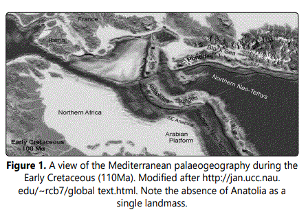
In the place of the Anatolia there was a large ocean, and the various continental fragments, which make up Anatolia, were distributed on either side of this ocean or formed islands within this ocean [1]. This ocean, called Tethys, existed at least since 350 Ma between the two large continents of Gondwana in the south and Laurasia in the north [1]. A further complexity was that the Tethys was not a single wide ocean as the present-day Atlantic, but consisted of several relatively narrow oceanic seaways separated by island arcs or continental slivers, called terranes, much as the present-day southwest Pacific [1], (Figure 1).
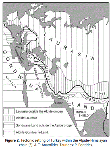
The final closure of the Tethyan oceans and the collision between the different terranes resulted in the Alpide orogeny and the creation of Anatolia as a single landmass in the Oligocene [1]. Turkey is geologically divided into three main tectonic units: the Pontides, the Anatolides-Taurides and the Arabian Platform (Figure 2), [2]. These tectonic units, which were once surrounded by oceans, are now separated by sutures, which mark the tectonic lines or zones along which these oceans have disappeared [1]. The Pontides exhibit Laurassian affinities and are comparable to the tectonic units in the Balkans and the Caucasus, as well as those in the central Europe [1,2] (Figure 2).
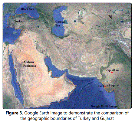
The geographic boundaries of the present day African peninsula, Turkey and the Indian peninsula have the potential to predict the effects of expansion driven by plate divergence.
Discussion
The Northern Turkey mainly consisted Strandja, Istanbul & Sakarya, together forming the Pontides. Pontides belongs to the Laurassian affinity. On the basis of the tectonic interpretations of Turkey, it is clear that in the early cretaceous, Anatolides-Taurides & Pontides were separated by the presence of Northern Neo Tethys whereas Anatolides-Taurides was separated from Arabian platform by the presence of the Southern Neo Tethys. If we consider this Tethys sea to be the one sea that separated Laurasia (in the North) & Gondwana in the South, it would be confusing and to eliminate this, it is important to consider the geologic ages of the different orogenies. The evidence of Variscan (Carboniferous) orogeny & Cimmerian (Late Triassic) orogeny as found from ophiolites provide clues to the presence of Paleo Tethys Sea (between Laurasia & Gondwana) which should ideally be different from the Neo-Tethys Sea between Anatolides-Taurides & Pontides with regards to the spatial segregation of these landmasses from Gondwana. These evidences are well documented as ophiolites & some radiolarian cherts along the lines or zones of suture (İzmir-Ankara-Erzincan suture) which is a boundary between Pontides (Strandja, Istanbul & Sakarya) and Central Anatoline crystalline complex.
On the basis of literatures and findings [1], Pontides rifted off from Gondwana in Ordovician & Anatolides-Taurides rifted off in Triassic whereas Anatolides-Taurides & Arabian platform rifted off in Triassic & reassembled in Miocene. This suggests that the tectonics of Anatolian peninsula is complex and that the Neo-Tethys might have been a part of the Paleo Tethys only, as we find the rifting and collisions of the continental fragments in the Phanerozoic, affecting the entire evolution of the Tethys. The presence of the Black Sea to the North of Pontides might suggest a remnant of the Paleo Tethys.
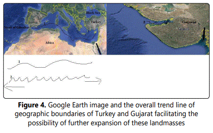
If we look at the configuration of boundaries of the present day African peninsula with the Mediterranean Sea at its north, we get a trend of line (Figure 3, 4) which gives an idea that this part of land is more matured and might not expand much except for the parts where smoothening is required. Similarly, comparing to the upper part of Gujarat (India), we find that the trend of line (Figure 3, 4) is more tight and constricted which might indicate more expansion of landmass there. On the basis of the geographic boundaries, the overall geographic configuration of Turkey is similar to the upper part of Gujarat above the Gulf of Kutch (India) with some differences which might be because of the differential stresses. Further to the north and to the northeast of Turkey, the presence of the Black Sea and the Caspian Sea is like an intracontinental sea. Similar to the Caspian Sea and the Black Sea, it might be possible that Gujarat & Rajasthan in India too might get separated by a sea. To the south of Turkey, the presence of the Arabian peninsula might be compared to the lower part of Gujarat below the Kutch. It is interesting to note that Arabian peninsula has extended/expanded much below to the South of Turkey. However, the lower part of Gujarat might be waiting to achieve a similar configuration. The possible expansion of the lower part of Gujarat (below Kutch) might not permit much of the entry of the Arabian Sea unless driven by a collapse of some land ridge or might be triggered by the presence of Gulf of Kutch & Gulf of Khambhat leading to a situation analytically similar to the strait of Gibraltar.
Conclusion
From the purview of the breakup and amalgamation of the landmasses, the evolution of the Tethys might be ascertained. The Pontides with a Laurassian affinity have traces of the Variscan orogeny which might have been succeeded by the Anatolides-Taurides which was mainly shaped by the Alpide orogeny. It is critical to comment on the stratigraphic succession of the Anatolides-Taurides and Pontides because of the presence of the Black Sea to the North of Pontides. Also the breakup of Gondwana pushing India & Africa to the North across Tethys leading to the opening of Indian Ocean might have impacted the Anatolian peninsula. It might have been that there was one Paleo Tethys sea that kept rising and falling at different times, during the rifting & collision phases of the mosaics of the landmass impacting the surge of water within different fragments of the landmass at different scales and at different times. It might be possible that the Tethys sea might resurrect. Whether, it might impact the western margins of continents like India and Europe in future or not, might be dealt with the help of understanding the tectonics, in the purview of the geology of the area.
Furthermore, analytical approaches like comparison of the current configurations of different continents might undergo potential challenges like ascertaining the geological ages for the purpose of correlation. Fossils can be of great help. Seismic studies might be carried out a bit more often to understand the evolving subsurface from time to time, specially for the basins. The possibility of separation of Gujarat and Rajasthan in India by a sea might require to address the structural viewpoints of faulting which might favour expansion at some point. It can also help in understanding the rate of expansion of the landmasses.
References
- Okay AI. Geology of Turkey: A synopsis. Anschnitt. 2008; 21: 19-42.
- Ketin İ. Tectonic units of Anatolia. Maden Tetkik ve Arama Bulletin. 1966; 66: 23-34.
- Şengör AMC. Tectonics of the Tethysides: orogenic collage development in a collisional setting. Annual Reviews of Earth and Planetary Sciences. 1987; 15: 213-244. doi: 10.1146/annurev.ea.15.050187.001241
