
Research Article
Climate Aridity: The Sultanate of Oman as a Case Study
Mathematics and Natural Science Department, Gulf University for Science and Technology, Kuwait
*Corresponding author: Dhari N Al-Ajmi, Associate Professor, Mathematics and Natural Science Department, Gulf University, Kuwait, E-mail: dhralajmi@gmail.com
Received: April 30, 2018 Accepted: September 27, 2018 Published: October 10, 2018
Citation: Al-Ajmi DN. Climate Aridity: The Sultanate of Oman as a Case Study. Int J Earth Sci Geol. 2018; 1(1): 1-3. doi: 10.18689/ijeg-1000101
Copyright: © 2018 The Author(s). This work is licensed under a Creative Commons Attribution 4.0 International License, which permits unrestricted use, distribution, and reproduction in any medium, provided the original work is properly cited.
Abstract
A comprehensive diachronic analysis (2004–2013) of precipitation and temperature regimes has been carried out at the national scale in the Sultanate of Oman (Oman), to investigate the impact of climate aridity on the vegetation system. In addition, trends in climate aridity have been analyzed using UNEP aridity index which is the ratio between rainfall and potential evapotranspiration on a yearly basis. During the examined time period, and particularly in the most recent years, a gradual reduction in rainfall and growing temperatures have been observed which have further widened the gap between precipitation amounts and water demand in vegetation.
Keywords: Aridity, Index, Precipitation, Temperature.
Introduction
In recent years, Oman has been experiencing growing water scarcity that can be mainly related to climate variations with poor soil and water management [1, 2]. Scholars, although still debating about the causes and possible remedies, recognize that a gradual warming process is occurring at wider scales, which is altering the rainfall regime at a local level [3, 4]. Bates et al. [5] indicates that observed warming over several decades has been linked to large-scale hydrological changes (i.e., increasing atmospheric water vapor content, changing precipitation patterns, reduced snow cover and widespread ice melting, changes in soil moisture and runoff).
In these regions, climate projections outline decreased water availability due to the lack of irrigation and irregular distribution. For example, spatial heterogeneity in climate regimes, which also shape the climate variations at a local level, is obvious in Oman due to its particular geographical form. As a matter of fact, changes in temperature and precipitation regimes are not evenly distributed on the country, but differ from place to place depending on both, the structural component (climate) of variability associated with the atmospheric system, and on the random component (weather).
One of the most important consequences of climate change is the increasing frequency of drought episodes and the growing impact of climate aridity on agroforest ecosystems [5]. In the case of aridity, the lack of rainfall depends on the local climate and represents a permanent or seasonal condition. On the contrary, drought is a transitory phenomenon related to the meteorological variability, as such, it can strike everywhere and at any time with levels of intensity and persistence, which cannot be determined a priority [6].
Aridity and drought, however, represent two sides of the same coin: along with the long-term trends triggered by climate change, there has been a tight recurrence of drought episodes in Oman, that have recently affected in an undifferentiated manner areas not previously prone to such phenomena, such as Northern Oman, as well as others where the pre-existing water shortage has been exacerbated by increased climate aggressiveness as noted in central and southern Oman [1].
Many regions in Oman are still characterized by a considerable year by year variability (e.g., Central, Northern and Southern areas, and South-Eastern coast). In several regions the rainfall seasonality, typical of the Monsoon climate, strengthens the effects and impacts of climate change: the recorded autumn-winter rainfall is three times higher than the spring-summer along the South-Eastern coast, by contrast, spring and summer rainfall is equal to half of the autumn-winter, while generally in the Northern and Central regions, the distribution of rainfall throughout the year is more evenly spread [2].
Considering the above-mentioned, structural trends in climate aridity and the increasing frequency in drought episodes and the strengthening of their negative impact on both man and the environment can lead to desertification. That being said, it was necessary to carry out a territorial analysis able to outline the overall national framework in terms of intensity, spatial distribution, and temporal evolution of water shortage caused by aridity, in addition to discussing the possible implications in the vegetation sector.
Methods
There is an array of aridity indices which have been developed in climatology literature, to quantify the extent of the gap between rainfall contributions and water demand in a specific location. Although there is an agreement over the general location of arid regions, there has been no unanimous agreement among the researchers that which measure should be used in a particular region, Since the aridity indices are calibrated against known aridity patterns, the simplest aridity index is based solely on precipitation which uses the criteria that an arid region receives less than 250 mm of precipitation per year while semiarid regions are commonly defined by annual rainfall between 250 to 500 mm [7, 8].
Thornthwaite [9] proposed an aridity index (AI) which is defined as:
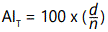 where d is water deficiency that is:
d=sum of monthly differences between precipitation and evapotranspiration for those months when normal precipitation is less than that of the evapotranspiration.
n=Sum of monthly values of potential evapotranspiration for the deficient month.
The most commonly used aridity index is however that proposed by UNESCO [10] which is based on the ratio of annual precipitation (P in cm) and potential evapotranspiration (ETp). Thus we have

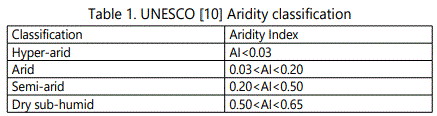
This measure intuitively appears to be very attractive and seems operationally simple because it is based only on two main parameters that define aridity. Warm arid regions have low precipitation and high rates of potential evapotranspiration therefore would have lower AI values. UNESCO [10] recommended a classification of climate zones based on this Aridity index AI which is presented in table 1 as below.
But the major constraint on the use of this UNESCO index is the availability of data on the local rates. Keeping in view this limitation, for the present study, we used instead the aridity index (Am) proposed by De Martonne [4] which considers temperature as a proxy for and is defined as follows.

Where P(cm) is the annual precipitation and T(°C) the annual mean temperature. As aridity increases, this index decreases and approaches to zero.
Results and Discussion
Between 2004 and 2013, the national territory showed an overall average AI value equal to 0.32 (Table 2) that indicates a significant water deficit in the equation of rainfall and potential evapotranspiration. From this view, the country as a whole could be classified as a Semi-Arid zone.
Moreover, during the investigated time period, quite complex and heterogeneous situations occurred, due to both climate variability related to the rainfall regime, temperature pattern, and the peculiarities of the geographical environment of the various areas concerned. With reference to the national aggregation scale, AI values fluctuated between a minimum of 0.0 and a maximum of 1.22, namely between conditions of hyper-arid and dry sub-humid climate (Table 2).

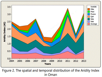
A close examination of the individual regional cases contributes to outlining an even more complex framework of substantially differentiated situations. For example, in the case of Qairon and Masira, AI values are among the lowest in the national rankings, owing to mean rainfall below 200mm/year and potential evapotranspiration almost twice higher. Indeed, in such regions from 2004 to 2013 the average AI value ranges between 0.14 and 0.46 reaching, in some years, minimum values close to the aridity threshold (AI<0.20). The northern regions (Saiq) shows index values close to or higher than 1, this is due to generally more abundant rainfall, such as to counterbalance or exceed what potentially required in terms of evapotranspiration. Also in south and north regions (Qairon and Saiq), however, climate variability entailed a fluctuation of the AI between minimum values of about 0.0 and maximum values even higher than 1.20.
The temporal pattern of Aridity Index can be easily inferred from figure 2, which shows the trend lines by geographical division of the Omanian territory (north, south, and Islands). The figure shows that the temporal variability of the examined phenomena also responds to a geographical gradient being much more evident in the northern regions than in the southern ones. Some of the most significant Omanian examples are represented by the cases of Qairon and Saiq. A full comparison, from a diachronic and territorial point of view, can be deduced from figure 2 Both maps show that most of the national territory falls within a range of AI average values between 0.20 and 0.50. This indicates that the climate can be defined as “semi-arid” according to the empirical classification associated with the values of the aridity index.

Conclusions
The Aridity Index (AI) is a widespread and simple tool that allows the opportunity to analyze the magnitude of the aridity and drought phenomena all over the national territory for a reasonable number of years (2004–2013). In addition to the absolute values and relevant climate classifications, the AI has allowed us to verify geographical characteristics and differences as well as occurrences in climate variations. Figure 1 shows the selected regions for the study. Considering the overall deterioration recorded during the last 9-year period, the most serious aridities phenomena affect only part of the Omanian territory (e.g., Qairoon and Masira) and marginally other southern regions. In these areas, the environmental conditions are more unfavorable, where vegetation, grazing, and other human activities affect local environmental conditions. Indeed, the increase in aridity has changed the status of the natural resources affected by the production activities, in particular soil, vegetation, and water resources. The data provided in this paper points out how Oman was affected by various degrees of water stress, mainly due to scarce or badly distributed rainfall throughout the year. The increase of bare soil or cover with sparse vegetation creates an increase of solar radiation. Consequently, the more the soil moisture evaporates, the more the ground becomes drier in a feedback process possibly, accelerating degradation of the Omani lands. In conclusion, considering all the mentioned facts, it should be kept in mind, that agro-ecosystems are the result of the adaptation to specific environmental conditions (climate) and any variation, which could alter the ecological and biogenetic balance. In which, needs to be reoriented in the name of sustainable land management policies and vegetation practices.
References
- Al-Ajmi DN, Idrees AM, Al-Hatrushi SM. Spatial and Temporal Analysis of Recurrence Time of Rainfall in the Sultanate of Oman. British Journal of Arts and Social Sciences. 2013; 12(1): 118-26.
- Bryson B, Zbigniew K, Wu S, Jean P. Climate change and water-IPCC technical paper VI. Tech. Rep. Intergovernmental Panel on Climate Change. 2008.
- Cook ER, Woodhouse CA, Eakin CM, Meko DH, Stahle DW. Long-term aridity changes in the western United States. Science. 2004; 306(5698): 1015-18. doi: 10.1126/science.1102586
- De Martonne E. Une nouvelle fonction climatologique: L'indice d'aridité. La Meteorologie. 1926; 449-58.
- IPCC. Climate Change 2007: Impacts, Adaptation and Vulnerability. Contribution of Working Group II to the Fourth Assessment Report of the Intergovernmental Panel on Climate Change. In: Parry ML, Canziani OF, Palutikof JP, van der Linden PJ, Hanson CE, eds. Cambridge, UK: Cambridge University Press; 976.
- Kwarteng AY, Dorvlo AS, Vijaya Kumar GT. Analysis of a 27-year rainfall data (1977 – 2003) in the Sultanate of Oman. International Journal of Climatology. 2009; 29: 605-17. doi: 10.1002/joc.1727
- Huntington TG. Evidence for intensification of the global water cycle: review and synthesis. Journal of Hydrology. 2006; 319 (1-4): 83-95. doi: 10.1016/j.jhydrol.2005.07.003
- Thornthwaite CW. An approach toward a rational classification climate. Geographical Review 1948; 38(1): 55-94.
