
Saka Indonesia Pangkah Ltd, Indonesia
The Ujung Pangkah field, in East Java, Indonesia is oil and gas fields which have been producing from Late Oligocene to Early Miocene of Kujung 1 limestone. One of the key factors which support Kujung 1 reservoir performance is reservoir quality. Secondary porosity is one of the key to determine reservoir quality which play significant role for Ujung Pangkah field performance.
Geologically, the Ujung Pangkah field is described as a Late Oligocene to Early Miocene shelf edge carbonate of Kujung 1 associated with NW-SE anticline, sealed by Middle Miocene of Tuban marine shale charged during Middle Miocene by Eocene fluvio-deltaic of Ngimbang source rock. Tectonically, the position of this field is located adjacent to the north of RMKS wrench fault zone which extends from east to west. Structural geology evolution of this field is related to the RMKS fault zone activities through time caused by regional compression at least begun during Early Miocene.
Tectonic product in the Early Neogene in Tuban trough, JS-1 ridge and central deep has formed a NW-SE structural high or ridge which perpendicular to the orientation of Paleogene ridge. Observation through all fields distribution give an impression that there could be a relation between structural configuration generated by regional compression in Early Neogene with reservoir potential distribution of Kujung 1 and CD carbonate which primarily controlled by secondary porosity generation as a product of karsting.
This paper is aimed to identify karsting zone over the Kujung 1 and CD carbonate level with seismic approach using seismic attribute to support geological modeling of Kujung 1 and CD carbonate reservoir in Ujung Pangkah field.
Keywords: Porosity, source rock, fault, seismic attribute, carbonate.
Waha Oil Company, Libya
Oil is one the more pollutants that threaten the ecosystem due to being over by the material hydrocarbon many of the most important of hydrogen, sulfide which consists of organic compounds containing hydrogen and carbon also contains non carbon materials nitrogen, sulfur, oxygen and some small quantities of metals such as nickel, vanadium and know the production process of the oil well that they bring the sites of the configuration to the surface where it should be up to the surface flow of natural and appropriate pressure and at the beginning of production is high, pressure which helps the production of the well naturally and helps to production for long periods and with the passage of time begins production oil in decline due to low pressure of the reservoirs and thus get up to access the oil to the surface under pressure less than the previous in some cases may not be so up and get up production and reservoir engineers to thins of artificial lift the most important of these means of injections of water associated with the oil in the layers of the earth that has become threaten the systems integrated environment as a result of not accompanying this process for studies of hydrological and environment fall which sets off alarm bells occurrence of seismic waves due to increased fracture and breadth during the injection process and water accompanying become a problem oil-producing counties in the most countries of the world.
Biography:
Fathi Elosta is currently working at Waha Oil Company, Tripoli, Libya.
1Mohammed V-Agdal University, Morocco
2Mohamed Ben Abdellah University, Morocco
3Ministry Delegate to the Minister of Energy, Mines, Water and Environment, Morocco
4University of Oulu, Finland
One of the adverse impacts of climate change is drought, which occurs more frequently in the High Ziz river Basin, Central High Atlas, Morocco. The application of drought index analysis is useful for drought assessment to consider adaptation and mitigation method in order to deal with climate change. By figuring out the level and duration of the drought. In order to analyze drought in the specific area, Standardized Precipitation Index (SPI) is an index to quantify the rainfall deficit for multiple timescales.
At present, the Standardized Precipitation Index (SPI) is the most widely used drought index to provide good estimations about the intensity, magnitude and spatial extent of droughts is widely accepted that SPI time scales affect different sub-systems in the hydrological cycle due to the fact that the response of the different water usable sources to precipitation shortages can be very different.
The aim of this study is to characterize the drought in the High ZIZ basin. It is based on the calculation of the standardized precipitation index SPI (Standardized Precipitation Index), to estimate changes of future drought conditions in the catchment studied.
This suggests that it is necessary to test the drought indices and time scales in relation to their usefulness for monitoring different drought types under different environmental conditions and water demand situations.
Keywords: High ZIZ basin, drought, climate change, standardized precipitation index (SPI).
Biography:
Diani Khadija is currently pursuing Ph.D at Department of Geology, Faculty of Sciences, Mohammed V-Agdal University Rabat, Morocco.
Banaras Hindu University, India
Seismic Inversion methods have been routinely used to estimate subsurface properties such that acoustic impedance, elastic impedance, density, ratio of P-wave and S-wave velocity using seismic and well log data together. These properties are very important to understand subsurface lithology and fluid contents. The aim of the present study is to perform seismic inversion using Simulate Annealing approach. Simulate Annealing is a global optimization algorithm used to find global optima of a nonlinear problem in the presence of large numbers of local optima. In the present study, pre-stack seismic inversion based on Simulate annealing is performed for Penobscot Field, Canada. The algorithm is performed in three steps; first, the algorithm is tested on synthetically generated data over 7 layer earth model. The inverted and expected results points out good performance of the algorithm with very high correlation value (0.99). Thereafter, in the second step, one composite trace is extracted from the seismic data and inversion is performed. After getting satisfactory results, in the third step, entire seismic section is inverted and verities of attribute cubes are estimated. The inverted results shows very high resolution images of the subsurface compared with the seismic section. The correlation is estimated to be 0.82 and RMS error is 0.354 m/s*g/cc. The impedance variation is estimated to be 4000-10000 m/s*g/cc of the region. The inverted section shows smooth variation of the attributes from top to bottom and hence concluded that the area does not have any major prospective zone. Thereafter, these attributes are transformed into the lame parameters which include lambda-rho and mu-rho parameters. These lame parameters are more sensitive towards fluids and rock properties. The analysis of these sections also confirms the non-availability of prospective zone. These analysis is performed for one inline and hence this can be not deny that the other part of the area have some other interpretation.
Keywords: Global optimization, Simulate annealing, Seismic inversion, Reservoir characterization
University Mohammed V, Morocco
A section made in the Tisdafine basin at the height of the Wadi Ferkla (Tinejdad, Anti Atlas Oriental) led us to a series of observations at the level of the outcrop as at the microscopic scale on the basis of nature lithofacies and palaeontological content. The sedimentological analysis revealed an organization in middle sequences, which reflects an evolution of the environments with changes in the deposition conditions. Dated Devonian and stalled from the Emsien to Givetian (Ward et al., 2013), this small basin has delivered an interesting Hercynian material with cyclo-sequences related to small variations of eustasy. The sequences show a repetitive bathy-increasing evolution with low amplitude withdrawal levels from Emsien to Givetian. It is a gulf environment first, containing diverse fossils of a shallow mid-ground, favorable for life with a precursor dwarf fauna, mostly crinoid limestone, ostracodes, test debris and corals. The basin deepens further, turbiditic figures announce slope conditions and organisms of varying sizes, adapt to increasingly deep environments, the benthic forms such as trilobites, crinoids, dacryoconarids, molluscs and the conodonts then goniatites and orthoceres frankly pelagic of a distal platform medium. This sedimentary activity suggests a filling phase ranging from the mobile platform to an open environment due to the eustatic dynamics that define the nature of the carbonates, their organization and the associated fauna.
The extension of the platform to the Devonian SE of Morocco allows to see through this series, a stratigraphic architecture with a tectono-eustatic control associated with subsidence, expressed according to the nature of the deposit of calcareous banks and marl-limestone alternations with a low detrital intake.
Keywords: Eastern Anti Atlas, Devonian, Emsian, Ferkla, Givetian, Cyclosequency, Tectono-eustatic, Dwarf Fauna.
1Sultan Moulay Slimane University, Morocco
2Mohamed University, Morocco
3Ministry of Energy, Morocco
The current study consists of a combined interpretation of gravity (Bouguer anomaly) and aeromagnetic (residual magnetic field) data to extract the lineament network affecting the Beni Mellal Atlas structure. Indeed, the computation of the horizontal gradient coupled to the upward continuation allowed to highlight three faults families oriented (N50-70°), N-S (N170-180°) and E-W (N90-100°). The projection of all springs on the structural map showed that those springs emerge at the over-cross areas of thrust-faults with the strike-slips faults oriented respectively N-S (N170-180°) and NE-SW to ENE-WSW (N50-70°).
Keywords: Gravity; Aeromagnetic; Lineaments network; Beni Mellal Atlas; Spring emergence.
Biography:
Ikram Boutirrame has received BS degree in geomatics applied to the geosciences from the Faculty of Sciences and Technics, Morocco and also received MS degree in Applied geophysic and Geological Engineering from Moulay Ismail University in Morocco. Currently, she is pursuing PhD degree, working on Geophysical prospecting and its application in hydrogeology in Faculty of Sciences and Technics of Beni Mellal, Morocco.
1University in Fes, Morocco
2National Institute for Scientific Research, Canada
The mapping of agricultural crops in arid and semi-arid regions is an essential application for better agricultural production and optimal management of water resources. Indeed, such an application allows decision-makers and farmers to ensure better agricultural planning (crop rotation, monitoring of crop health, yield estimation) and reasonable management of irrigation water resources by calculating water requirements for each crop. Crop type information is also useful for parameterizing crop growth patterns. In the last decade, space-based remote sensing has become an essential tool for crop mapping, often based on hyperspectral imagery or multitemporal series. However, few studies have used a single image to map crops at an early date of the agricultural season. In this sense, the present work demonstrates the feasibility of producing crop type maps using satellite (S-2A) satellite Sentinel-2A. This work has two main objectives. The first objective is the evaluation of the potential of Sentinel-2 data for crop mapping in the Tadla plain. While the second is the most favorable period for the discrimination of different cultures using a single S-2A image. In order to achieve these objectives, we have acquired a set of seven images of the S-2A satellite, which were corrected for atmospheric effects by applying the Sen2Cor algorithm. Maps of crop types were produced at a spatial resolution of 10 m. Support Vector Machines and Random Forest Classifiers were applied for each image. The favorable period for mapping was chosen with an overall accuracy of 96.35% and a kappa index of 0.95. The results obtained indicate a single S-2A image should be sufficient for the discrimination between cereals (wheat and barley), sugar beet, alfalfa, olive, citrus and arboriculture in an arid to semi-arid climate.
Keywords: Sentinel-2, crop mapping, vegetation index, Tadla irrigated perimeter, Morocco.
Saka Indonesia Pangkah LTD, Indonesia
The offshore Northeast Java Basin is one of the largest basins in Indonesia and one that contains complete hydrocarbon systems from Middle Miocene Tuban formations to Pre Tertiary basement formations. The offshore East Java Basin is located on the southeast margin of Sundaland and is dominated by a series of northeast trending basement highs and intervening half – grabens that formed during late cretaceous to tertiary times along the southeast margin of the Sunda Plate (Manur and Barraclough, 1994).
In Pangkah Field, Carbonaete Oligo-Miocene has a diversity property of reservoir. Challenges to identified characteristic resevoir using stochastic inversion method. Within this method enhance our detail in classification distribution of carbonate facies. East Java projects using deterministic seismic inversion has been successfully executed but need additional data and analysis for better visualization of reservoir, caused by heteregeneous reservoir due to various property and thickness. Some of the benefits of these methods are inverted impedances rock properties calibrates with well data, seismic inversion process reduces the wavelet and tuning effects estimating the thickness of a thin bed to improving the understanding of the reservoir geology for exploration strategy and development. We used a stochastic inversion methodology, which simulates many possible realizations, to better discriminate the thickness and real extent of the carbonate/shale layers, and estimate the uncertainties of carbonate volumes (P10, P50 and P90) in the Kujung I play and CD Carbonate Play of the Pangkah PSC.
Keywords: Hydrocarbon, sthocastic, carbonate, facies, realization.
Cadi Ayyad University, Morocco
The evolution of major elements in the rocks in BeniBousera ultramafic massifindicates a fertile lherzolites that showing an enrichment in incompatible major elements (Al, Na, Ti and Ca), associated with other lherzolites are relatively depleted and rich in compatible elements (Ni, Cr and Mg). As well, it clearly shows a complexity in the trace element distribution, suggesting an association of rocks having underwent a high partial melting rate with others having underwent only a weak degree of melt. Which had proposed an history including different episodes of partial melting associated with a local fractional crystallization, all was combined with subsolidus reactions.
The lithospheric signature in this rocks is underlined by an abnormal enrichment in light rare earth elements and by the presence of a high isotopic heterogeneity in Sr and Nd. Such a process is explained by the late injection of “exotic” liquids whoʼs originated from mantle and crustal input “terrigenous sediments”.
In some peridotites, the rare earth concentrations and isotopic ratios of Sr and Nd are similar to those of MORBs. They would, therefore, be interpreted as evidence of an old fragment of the asthenosphere emplaced at high depth. Others are depleted in light rare earths and show a high isotopic ratio of Nd and a low isotopic ratio in Sr. Similar to lithosphere-type spinel lherzolite and xenoliths indicating an old piece of “depleted mantle” separated from the convective mantle and added to the subcontinental lithosphere.
As a result, the continental lithospheric mantle, currently represented by the BeniBousera massif, is separated from the asthenosphere and incorporated in the subcontinental lithosphere over a long time ago, accompanied by an old age of isotopic stability of 1.3 MA compared to Depleted Mantle. It has a very heterogeneous structure with vertical as horizontal isotopic zonation depending on the age of the continental lithosphere and late enrichment with exotic liquids.
Keywords: BeniBousera ultrabasic massif, fertile lherzolite, asthenosphere, continental lithospheric mantle, subsolidus reactions, exotic liquids.
Biography:
Zahra Mourabit with a master degree in applied geosciences to mineral and energy resources. During 2 years, she has been trained as a geoscientist in applied fields and that allowed her to enter in the active life of the research and to integrate the world of the environmental entrepreneurship of the exploration and prospecting of the mining. She is a student-researcher in geology at the Faculty of sciences, University of Cadi Ayyad, Morocco. Her work focuses specifically on a petrological study and the isotopic geochemistry of BeniBousera peridotites and crystallophyllian units in the Rif belt north of Morocco. Her thesis aims to clarify the origin and history of emplacement of these units, for general to contribute to the understanding of the geodynamic evolution of the Alboran domain and will allow proposing an orogenic model of Betic-Rif arc.
China University of Geosciences, China
Using the heat flow to study the deep structure of the lithosphere has been seen as a common and effective geophysical methodology. The current study focuses on the characteristics of the heat flow and its geological significance in marginal seas of the northwest Pacific Ocean. According to the 4001 heat flow data collected from the marginal seas, the distribution map of the heat flow in the northwestern Pacific Ocean is drawn. Based on the formation time of marginal seas, the frequency of heat flow distribution is calculated, while the heat flow value and the seabed geology are also comparatively studied. The distribution law of heat flow in the “Trench-Arc-Sea” system, the relationship between the structural properties of the lithosphere and the heat flow, as well as the controlling factors of the abnormal heat flow, have all been discussed in this study. The results of the current study show that the magnitude and the dispersibility of the heat flow in the marginal seas are roughly negatively correlated with their formation time. The formation time of the Sea of Okhotsk is earlier (30-65 Ma); correspondingly the heat flow value (86.8 mW/m2) and the standard deviation (3.727) are relatively lower; whereas the Okinawa Trough is still expanding with its relatively high heat flow (139 mW/m2) value and high standard deviation (7.001). In the “Trench-Arc-Sea” system, the heat flow value is characterized by identified as “Low (Trench) –High (Arc) -Relatively High (Marginal Sea)”; the heat flow value in Kuril-Kamchatka Trench, Japan Trench and Ryukyu Trench is about 30 mW/m2, while their corresponding island and arc area heat flow values are that of two to three times. As the structural properties of the lithosphere are different, their heat flow values are obviously different. The heat flow values of the continental crust in marginal seas are overall lower than that of the oceanic crust. Likewise, different subduction properties have different effects on heat flow, the cold subduction of the plate leads to a lower heat flow value in the Kuril-Kamchatka Trench, while the hot water caused by the subduction fault increases the heat flow value of the oceanic plate outside the Japan Trench.
Biography:
Jiang Dexin is a postgraduate student in China University of Geosciences (Beijing) and born in Chongqing, China on Oct.3, 1995 and majoring in marine science oriented to the Analysis of Petroliferous Basins. He has received the bachelor degree in Petroleum Geology at Chengdu University of Technology, China in 2013 and Currently studying for a master degree in China University of Geosciences (Beijing), focusing on petroleum in the marine area.
China University of Geosciences, China
The bioturbated horizons identified from Member Two of the Paleocene Funing Formation (E1f2) in the Jinhu sag, have not been previously assessed to ascertain their influence on reservoir quality. Owing to that, conventional thin section, pulse decay permeametry, pressure decay porosimetry, Field Emission Scanning Electron Microscope (FESEM) and Energy Dispersive X-ray Spectroscopy (EDS) methods were used to analyze the significance of bioturbation in controlling porosity and permeability on selected cored intervals from one well. Intensely bioturbated core slab samples A and B selected from Bian-5 Well are dominantly controlled by Ophiomorpha and Macaronichnus, respectively. Results showed that Ophiomorpha and Macaronichnus in sample an exhibited sediment cleaning activity with better sorted grains in burrow fillings. Mud and clay were removed from the burrow filling and directed towards burrow lining and/or host sediment by burrowing organism resulting in well sorted burrow fill matter; the net effect, enhanced isotropy and increased porosity in burrows fills. Macaronichnus ichnofabrics in sample B also exhibited sediment cleaning activity causing reduction of local porosity in host sediment and an outcome of permeability improvement in burrows. Reservoir quality of bioturbated sandstone of Bian-5 well in the Jinhu sag is, therefore, dependent on activity of burrowing organism, burrow structure, bioturbation extent as well as the existence or nonexistence of burrow fill or lining.
Biography:
The Main author is currently (2015 to Present) a final year PhD research student at the China University of Geosciences, Beijing studying Oilfield Development Engineering. His research focuses on Reservoir quality and Rock property trends of bioturbated facies. He holds a Masterʼs degree (MEng) in Oil and Gas Engineering from the China University of Geosciences, Wuhan (2011 to 2013). Prior to that, he undertook his undergraduate study in Marine Engineering (BSc) at the Regional Maritime University, Ghana (2005 to 2009).
1State Key Laboratory of Petroleum Resources and Prospecting, China
2China University of Petroleum, China
3SINOPEC Key, China
4Petroleum Exploration and Production Research Institute, China
Recent hydrocarbon exploration shows the second member of Eocene Kongdian Formation (Ek2) of the Cangdong Sag in Bohai Bay Basin, East China has great shale oil potential, but there is still a lack of studies of the reservoir evaluation of the Ek2 shale. In this study, twelve core samples of the Ek2 shale were collected from one well to investigate their pore structure and fractal characteristics by using Cold-Field Emission Scanning Electron Microscope (CFESEM) observation and low-pressure N2 adsorptiondesorption (LPN2AD) test. The results show that the Ek2 shale has high-abundance of total organic carbon (TOC) ranging from 0.56 wt% to 5.56 wt% and low-maturity characteristics with vitrinite reflectance (Ro) of 0.51%-0.73%. Specific surface area (SSA) and total pore volume (TPV) are much lower in the range of 0.870-9.829 m2/g and 0.0025-0.0240 cm3/g, respectively. CFESEM observation demonstrates that the Ek2 shale with a small number of organic pores mainly developed intraparticle pore within clay aggregates and dissolution pores. TOC does not play a key role in the pore development during low-maturity stage. Using Frenkel-Halsey-Hill (FHH) model, the fractal dimensions (D1, D2) were identified at the relative pressure (P/Po) of 0.01-0.50 and 0.5-1.0, respectively. D1 values representing shale pore surface roughness with a range of 2.010-2.813 increase when clay content increases, which leads to an increasing number of micropores and complicates the pore surface. D2 values denoting shale pore structure complexity, varying from 2.442 to 2.906, show a positive relationship with the contents of feldspar and analcime, but a negative relationship with the content of carbonate minerals. Feldspar and analcime are easily corroded to produce more irregular dissolution pores, resulting in an augment of shale pore structure irregularity. The presence of carbonate minerals serving as the main cement in the Ek2 would cause a decrease of pore volume and pore structure irregularity.
1Zayed University, United Arab Emirates
2Yarmouk University, Jordan
3Ministry of Energy, United Arab Emirates
This paper presents the most comprehensive datasets of ambient fine particulate matter (PM2.5) for the UAE from 1980-2016. The long-term distributions of PM2.5 showed that the annual average PM2.5 concentrations constantly exceeded the EPA and WHO guidelines. They varied from 77-49 µg/m3 with an overall average of 61.25 µg/m3. While the inter-annual variability in PM2.5 concentrations showed relatively a cyclic pattern, with successive ups and downs, it broadly exhibited an increasing trend, particularly, over the last fourteen years. PM2.5 concentrations displayed a strong seasonal trend, with greatest values during warm summer season, a period of high demand of electricity and dust events. The lowest values found in autumn are attributable to reduced demand of energy. Also this period coincided with decreased atmospheric temperatures and high relative humidity that are likely to reduce the secondary formation of PM2.5. The spatial changes of annual average of PM2.5 concentrations exhibited gradual downward trends to the north and northeast direction. Airborne PM2.5 is prevalent in the southern and western regions, where the majority of oil and gas fields are located. PM2.5/PM10 ratio varied from 0.52 to 0.80 with a mean value of 0.72, indicating that ambient aerosols are principally associated with anthropogenic sources. Peaks in PM2.5/CO ratio were frequently observed during June, July, August, although few were concurrent with March. This indicates that secondary formation plays an important role in PM2.5 concentrations in these months, especially as the photochemical activities are relatively strong in these periods. The lowest PM2.5/CO ratios were found during September, October and November (autumn) suggesting a considerable contribution of primary combustion emissions, especially vehicular emissions, to PM2.5 concentration. PM2.5 concentrations are positively correlated with SO4 levels, suggesting that SO4 aerosols constitute an important portion of PM2.5. In addition to sea spray, the enhancement of SO4 concentration in the coastal region is due to fossil fuel burning from power plants, oil and gas fields and oil industries where they may contribute to SO4 levels through photochemical transformation of SO2. The population-weighted average of PM2.5 in UAE was 63.9 µg/m3, which is more than three times greater than the global population-weighted mean of 20 µg/m3.
Keywords: PM2.5, aerosol, emissions, UAE.
United Arab Emirates University, United Arab Emirates
Electrical Resistivity Tomography (ERT) survey across the study area provides accurate and consistent technique of estimating the resistivity/conductivity values utilizing six ERT profiles. Several shallow features of geotechnical concern potentially related to underground highly conductive, loose soil and poorly cemented conglomerates have been identified and an attempt has been made to evaluate the spatial variability of the depth of such features and quality of the bedrock beneath the site. According to geophysical ERT results, surface outcropping earth materials can be classified into: Highly resistive/low conductive surficial dry soils and other materials exposed on the surface and extended to approximate depth of 5 m below ground surface. Very low resistive/highly conductive layer encountered under the above layer at about 5 m and extended to approximate depth of 8 m-12 m below natural ground surface. Few isolated anomalies of low resistivity zones in the bedrock have been detected within ERT profiles at the interface between the bedrock layers and were interpreted to represent zones of high water saturated weathering/soft fractured bedrocks and confirms that the water level and the saturation zone in the area. This study may help in the groundwater management across the area.
Biography:
Dr. Amir Gabr has obtained his Ph.D in Applied Geophysics from Ain Shams University, Cairo, Egypt in 2001. He has more than 20 Years of industry and academic experiences at GUPCO –AMOCO Petroleum Company in 1989 for 10 years. His experience in the petroleum industry include multiple positions like Well site Geologist, Exploration Geologist in Potential Field Division and Section head in Geophysics division and he has a practical teaching experience in the UAEU for Geoscience – Geophysical methods application and teaching of several courses Applied Geophysics, Geophysical Exploration, Petrophysics and Well Logging.
1National Center for Water Resources Planning and Investigation (NAWAPI), Vietnam
2University of South Carolina, USA
Water resources in the Mekong River Delta, Vietnam (MRD) are important factors that greatly influence the livelihood and economy of this region. The MRD occupies an area of 40,577 km2 with elevations ranging from 0.3 to 0.7 m above mean sea level; hence it is projected to be significantly influenced by salt water intrusion due to climate change.
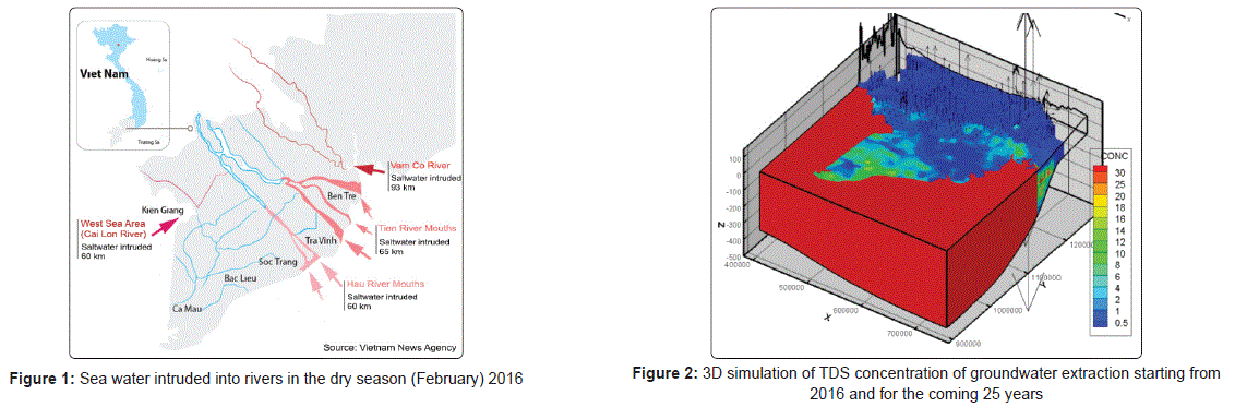
Surface salt water intrusion is a natural phenomenon that occurs annually in the MRD from December to May and peaks in late April or early May. This phenomenon has been increasing not only in frequency but also extremeness due to climate change. The salinization of groundwater resources in sediment granular aquifers has been observed in the MRD more than 100 km inland. Saline groundwater exists in all aquifers with from both paleo and modern ages. This limits access to fresh water resources for the population of the MRD.
The historic salinity intrusion in the 2015-2016 dry seasons in the MRD, which resulted from a long lasting abnormal El Nino event in the Pacific Ocean, heavily damaged the coastal provinces of the MRD. The hydrological records at the Tan Chau station (Mekong River) from 1926 to present show that the peak flow and total volume of the flood was the lowest in 2015, at approximately half of the largest flood on the record and 60% of the annual average flood. Since the 2015 flood was very weak, the flow into the MRD during the dry season was also considerably lower, at 65-70% of the annual average. With this low flow, salinity intrusion during the 2016 dry season was the worst on record. Until the end of February 2016, saline boundaries of 4 g/L intruded as far as 93 km inland in the Vam Co River, in the Tien (Mekong) River Mouth intruded 65 km inland. The salt water intrusion at Hau River Mouth and West Sea Area (Cai Lon River) was 60 km inland (Fig. 1).
This study aims to quantify the impact of the sea level rise and projected precipitation on the salinity intrusion in the MRD for the period of 2015-2050. Two projected scenarios (RCP4.5 and RCP8.5) were selected to investigate the impact of climate change. The MIKE 11 model (Hydrodynamic module and Advection - Dispersion module) was used to investigate the impact of salt water intrusion due to the sea level rise and projected precipitation. The preliminary results indicate that the MIKE 11 model was able to simulate the discharge and salinity concentration in the MRD. The results from the simulations of the scenarios revealed that salt water will intrude deeply inland in the future threatening the agricultural practices and livelihoods of the farmers in the MRD.
The distribution of fresh and saline groundwater in each aquifer in the MRD was simulated based on 3,083 results of geochemical analyses of groundwater taken from 903 geological boreholes of the National Groundwater Monitoring Network (NGWMN) and 1,734 geochemical analyses of groundwater taken from 13 provinces in addition to the NGWMN in the MRD. Additionally, the results of 3,782 vertical electrical sounding (VES) points and 341 well logs were also included in the simulation. The hydraulic heads and TDS concentrations in groundwater starting from 2016 and for the coming 25 years were simulated for the seven existing aquifers in the MRD (Fig. 2). For the coming 25 years, the water table in almost all aquifers in the MRD is expected to experience a drawdown exceeding 4 m. The modelled average delta-wide drawdown increases with depth. Large drawdown areas are located around major cities and industrial zones where the groundwater extraction is expected to be extensive. In the model, depression cones are observed in some places for all the aquifers with the groundwater levels reduced well over 20 m, even up to 40 m. The excess of the groundwater extraction rate compared to the recharge provides an estimate of the amount of groundwater depletion, while negative values occur in regions where extraction rates are sustained by groundwater recharge.
Keywords: Saltwater intrusion, Salinization, Mekong River Delta.
Universitas Pembangunan Nasional “Veteran”, Indonesia
Yogyakarta is one of the provinces threatened by two sources of major natural disasters is volcanic eruptions and tectonic earthquakes. The earthquake that occurred in Bantul, Yogyakarta, Indonesia on May 27, 2006, included a large earthquake because it had a 6.3 Mw power with a depth of 11.7 km so that the earthquake included shallow deep and destructive earthquakes. The epicenter is located in the coordinates 8.03 S and 110.32 E. In several studies this earthquake occurred due to the movement of opak faults triggered by the interaction of tectonic plates in the southern part of the island of Java. We analyzed the movement of active faults in the Opak River which was interpreted as causing this earthquake. From the results of the analysis of the active opak fault relative direction SW-NE which is almost in line with the direction of the opak river flow. This is supported by the damage data that is relatively in line with the movement of fault is SW-NE so this supports our interpretation that opak active faults are a cause of earthquake in Bantul, Yogyakarta. Data processing was done with GIS software and we found a relationship between the three variable discussed in this poster is active opak fault, plate tectonic interaction and earthquake that occurred in Bantul, Yogyakarta.
Biography:
Riomas Harjuno Ajiis a geological engineering student at the Universitas Pembangunan Nasional “Veteran” Yogyakarta. He had graduated from Sleman 1 State High School in 2015 and was accepted in geological engineering at the Universitas Pembangunan Nasional “Veteran” Yogyakarta in the same year. He often visited to various seminars, workhop and conferences related to geology and presently he is pursuing 7th semester at the university or in the final year before graduating. He was a board member of the Universitas Pembangunan Nasional “Veteran” Yogyakarta Geological Engineering Student Association (HMTG) and a member of the Indonesian Geological Student Association (PERHIMAGI). His area of interest is about coal, oil and gas and Geochemistry.
1Tshwane University of Technology, South Africa
2University of South Africa, South Africa
Microorganisms including fungi and bacteria are used in the biotechnological procedures through exploitation of their natural metabolism, especially the ligninolytic enzymes in the biodegradation of pharmaceuticals. The present study intends the use of the non-sterile stirred fluidized bioreactor (NSFB) driving fungal consortium for the removal of three selected pharmaceuticals, carbamazepine (CBZ), diclofenac (DCF) and ibuprofen (IBP) from synthetic wastewater. The spectrophotometrical method was used to determine the enzymatic activity and the SPE followed by the UPLC-(+)-ESI-QToF-MS methods performed to assess the analytes removal from the NSFB. South African fungal consortium of A. niger, M. circinelloides, T. polyzona, T. longibrachiatum and R. microsporus in the NSFB was found producer of ligninolytic enzymes laccase (Lac), manganese peroxidase (MnP) and lignin peroxidase (LiP) in the working conditions, pH 4.5 ±0.5 and continuous air supply (dissolved oxygen 8.5 ±0.5 mg/L). MnP was more produced followed by Lac and LiP. The fungal consortium demonstrated a removal efficiency of 89.9% of CBZ, 95.7% of DCF and 90% of IBP achieved within 24 hrs and more than 98% after 5 days. Analyte metabolites were identified, including Iminostilbene, 10,11-dihydro-10,11-dihydroxy CBZ, acridine, 2-hydroxy iminostelbine, 9-hydroxymethyl-10-carbamoyl acridan, iminoquinone, and 9-acridine carboxaldehyde from CBZ, 4ʼ-hydroxy DCF, 5-hydroxy DCF, 3ʼ-hydroxy DCF 4ʼ, 5-dihydroxy DCF and 3-hydroxy-4-ethoxy DCF from DCF and carboxyl IBP, 1-hydroxy IBP, 2-hydroxy IBP, 1,2 dihydroxy IBP and the two sodium adduct 1- and 2-hydroxy IBP. The pharmaceuticals degradability was found higher than their lower elimination in conventional biological wastewater treatment systems.
Biography:
Teddy Kabeya Kasonga is currently a PhD student at the Department of Environmental, Water and Earth Science of Tshwane University of Technology, Pretoria, South Africa. Kasonga has obtained D.E.S degree (classified level 9) in physical chemistry at the University of Kinshasa. He is member of several organizations and lecturing at the Department of Biology and Applied Techniques of the “Institut Supérieur Pédagogique de la Gombe” since 1998. He has 5 published papers and 3 under review, particularly in the field of sickle cell disease and water science and technology (EDCs removal).
1Dilla University, Ethiopia
2Addis Ababa University, Ethiopia
The Fentale-Metehara blisters and blister caves in the Main Ethiopian Rift are unique and spectacular geological features found in such number and extent in this area only. These features will be ideal sites for establishing a geopark. This will provide tourists more opportunities and options to visit and to be employed for the local community. Supervised classification was utilized for the decadal landuse and land cover (LU/LC) mapping of the study area. To document all the blister fields in a geo-database schema Google Earth accompanied by detailed field investigation has been carried out. For mapping the geology of all blister fields a detailed field investigation was also carried out. Susceptibility to destruction of these features has been analyzed based on the frequency ratio technique and natural (topographical factors, drainage systems, Lake Beseka expansion and lava flows) and human induced (urbanization, irrigation activities and infrastructure lines) triggering factors. The total of 161 blister caves and 478 blisters were mapped and well documented. Most of the blister fields fall on high to very high susceptibility zones. It was found out that further expansion of Lake Beseka, as well as the human induced factors including infrastructure development could lead to further destruction of low to very low susceptible zones of the blister fields. The LULC analysis further corroborates this conclusion as it has been observed that the Lake Beseka, farmlands and settlements expanded at about 46.2 km2, 46.6 km2 and 3.3 km2 area respectively during the last four decades. In conclusion, proper and well-organized documentation of the blister fields in a geo-database schema and also the high quality susceptibility zonation map, which were produced in this study, will help in the preservation efforts of these unique geoheritage resources.
Keywords: Blister; blister cave; frequency ratio; geoheritage; geopark; susceptibility
University in Fes, Morocco
For better conservation and rational management of a geosite, an adjusted assessment is a necessary step for the analysis and comparison of geosites. It must be based on chosen criteria allowing the selection of objects requiring protection, determination of the nature as well as the range of protection and recovery measures.
This is why we explain in this work, three methods of evaluation of geosites, the most basic of which is that of V. Grandigirard where he developed, as a first step, theoretical reflections based on the judgment of factors representing the value scientific geosite as well as indicators that it considers secondary. This method has been improved, in a second step, by adding some modifications allowing competent people to express their opinion as to the value of a geotope.
The second evaluation method, developed by E. Reynard, is also concerned with the scientific value of geosites to which it adds additional values such as ecological, cultural, aesthetic and economic values.
Whatever the method used, the final results obtained are illustrated according to the purpose of the evaluation by syntheses, tables or diagrams.
The application of these methods allowed us to illustrate them in order to facilitate their comprehension and also to allow to conclude by criticisms or the establishment of in-depth comparisons of the results obtained.
In this work, we develop a new scientific method for evaluating geosites based on the old methods above, this method will be very useful for geologists, geomorphologists and biologists; and which will include geological, geomorphological, biological, cultural, touristic and aesthetic values.
Keywords: Geosite assessment, scientific value, geological value, cultural value, tourism value, biological value, aesthetic value.
Biography:
Narmine Assabar is currently a second year PhD Student. She obtained her bachelorʼs degree in 2011 and university degree in mineral and environmental engineering and continued studies in environmental geology degree and later admitted to masterʼs degree in natural heritage and development durable.
1Chinese Academy of Science, China
2China University of Petroleum, China
3Dagang Oil field Company of Petro China, China
Commonly-used tools for oil-source correlation, such as mass chromatograms of biomarkers and bivariate cross-plots of geochemical parameters, cannot process multiple geochemical variables and plenty of samples simultaneously, leading to uncertainties in results and even failures. In contrast, multivariate statistical methods can simultaneously deal with plenty of samples and multiple geochemical variables. This problem in oil-source correlation can be solved when a suitable multivariate statistical method is applied properly. Based on theoretical analysis, discriminant function analysis (DFA) is selected in this study, as it is superior to the other multivariate statistical methods already used in oil-source correlation including principal component and hierarchical cluster analyses. In the slope of the Qikou Depression, the main source rocks in the Sha-3 (Es3) and Sha-1 Members (Es1) of the Paleogene Shahejie Formation were deposited in similar depositional environments. These source rocks cannot be distinguished with the commonly-used tools. We extended geochemical parameters to explore more useful information and used stepwise DFA to select informative parameters and to develop the discriminant model for oil-source correlation. Of 58 extended parameters, 23 were selected. This selection result is supported by the characteristics of geochemical parameters of the source rocks. The selected parameters were used to develop the discriminant model for oil-source correlation which achieved high correct rates of original validation (96.8%) and leave-one-out cross-validation (89.4%), indicating a sufficient discriminatory power. The oil-source correlation results with high posterior probabilities, showing strong similarity between the sources and oils, are consistent with geological conditions and illustrate that there is still a significant exploration potential in the study area, especially for the Sha-3 petroleum system. The case study further demonstrates that DFA is a very powerful tool for oil-source correlation with the accumulation of geochemical data of source rocks and oils.
Biography:
Dr. Liuping Zhang had received B.S. degree from Beijing University in 1983 and Ph.D. degree in Geochemistry from China University of Geosciences in 2000. He is currently works as a professor in Institute of Geology and Geophysics, Chinese Academy of Sciences and has more than 30 yearsʼ experience in studies of petroleum geology and organic geochemistry. His research interests include: (1) hydrocarbon origins, (2) unconventional hydrocarbon resources, (3) petroleum migration, accumulation and distribution pattern and (4) Petroleum seepage and prospecting methods.
University of Port Harcourt, Nigeria
This research focuses on mapping hidden stratigraphic features on a 3D seismic data with approaches better than direct/commercial approach. Materials used in this research are seismic data, well logs, checkshot and base map of the study area. The approach used is the Short Time Fourier Transform (STFT) programmed into MATLAB and Suffer-8 Software and algorithm used is based on Fast Fourier Transform (FFT). A reservoir window/sand interval identified on well logs in depth were converted to time (frequency) using checkshot at 4ms decomposed with STFT and Discrete Fourier Transform (DFT). Results showed sand interval extracted in time and seismic amplitude sliced at 4 ms and 10 slices obtained – a time slice before the top sand interval (2.440 sec) and below the base sand interval (2.468 sec). The original seismic magnitude and phase plotted for the top sand top (2.440 sec) was transformed using the DFT and STFT which determined the domain frequency in terms of seismic attributes, magnitude and frequency. Identified lithologies in the studied section across the wells are sand, sandy shale and shale. A subtle stratigraphic feature – Channels has been identified. The time slice interval of 2.436 – 2.472 sec, showed variations in amplitude properties with depth suggesting changes in formation fluid and sequence boundary. Resolving hidden stratigraphic features on seismic data require high frequency enabled tuning and has been achieved with the STFT and DFT. Frequency maps (slices), the reservoir window identified with the STFT approach gave localized stratigraphic feature, better results compared with DFT and time domain.
Keywords: Short Time Fourier Transform, Discrete Fourier Transform and Hidden stratigraphic features
Biography:
Dr. Ideozu is a geoscientist, goal oriented, team player, excellent interpersonal relationship, dedicated, committed to work. His academic training was at the University of Port Harcourt and obtained B.Sc. Geology, M.Sc. Petroleum Geology / Exploration Geophysics and Ph.D Petroleum Geology and his Area of specialization are Petroleum Geology / Sedimentology and Reservoir Geology. His Core specialties are Sedimentology - Core and outcrop studies including Fluvial, deltaic, deep-water depositional settings and Reservoir modelling. Research interests are biostratigraphy (Micropaleontology & Palynology), petroleum geochemistry, clay mineralogy, structural geology, Exploration Geophysics and Mineral Exploration. Dr. Ideozu has eight years of Teaching and Research Experience and 13 years Professional Experience.
Federal University of Technology, Nigeria
By using the WAVEWATCH-III (WW3) wind-wave model, this work has investigated the wave energy potentials in the mid-Atlantic by utilizing a 37 year (1980-2016) significant wave height (SWH) and mean wave period (T_m) data which were got from the analysis of wave climate predictions. The spatiotemporal variations of the wave energy resource are discussed. Results showed that wave energy is richest (11.5-14k W/m) in the extreme northwestern mid-Atlantic and is therefore an excellent region for the installation of wave power plants for electrical energy generation. Temporal variation showed that 1992 was a year of relatively rich wave energy in the Ocean. From analysis, the wave energy groups 0≤wp≤5 and 5≤wp≤10 had the highest frequencies in the Ocean. Furthermore, spatial trend analysis of the annual and summer averaged wave power revealed that stronger trends (0.03-0.1 kW/m/year) in both cases, distribute in the southern part of the Ocean, while stronger trends (0.04-0.085 kW/m/year) dominate the northern part during winter. The Ocean exhibits an overall trend of approximately 0.022 kW/m/year all through the years and seasons.
Statement of the Problem: In wave power assessment, the development and exploitation of oceanic energy play a key role in easing the global energy crisis. The ocean energy offers the advantage of fresh, renewable, enormous reserves and extensive distribution but its instability reduces development. The choice of the wave power site selection over any oceanic region relies on the spatial stability of wave power density. A better acquisition and conversion of wave energy is achieved by a better stability in wave power. The conversion efficiency of the ocean energy conversion transpose is greatly reduced by instability in the wave energy density thereby, damaging the power equipment. Also, the distribution of relative rich energy regions of wave power density in the sea identifies ideal locations for wave power plants. In all, the characteristic wave energy resource in the sea is analyzed in order to supply references for the wave energy resources growth, navigation, oceanic engineering, catastrophe avoidance and decrease.
At present, little or no studies have been carried out on wave energy potential in the mid-Atlantic. By using a 37-year, 6-hour, SWH and T_m data obtained from ECMWF and computed by WW3 model, this study extends the work by Osinowo et al. (2016) by categorizing the wave energy particular to the mid Atlantic for different ranges of wave power density. Also, the distribution and spatio-temporal trends of wave energy will be evaluated. Furthermore, investigation will be made to identify sites of relative rich wave energy, ideal for the installation of wave power plants for electrical energy generation.
Biography:
Dr. Osinowo Adekunle Ayodotun had received a Ph.D and D.sc degrees in Physical Oceanography (Marine Meteorology Option) from the Ocean University of China. He is currently a researcher and a lecturer in the Department of Marine Science and Technology, Faculty of Earth and Mineral Sciences, Federal University of Technology, Akure, Ondo State, Nigeria. His research interests include Ocean wave simulations and climatology and wind-wave energy resources in oceanic basins.
University of Venda, South Africa
The Soutpansberg Group contains significant clayey sediments which are used for pottery and manufacturing of burnt bricks. The clayey sediments and rocks in Vhembe District were geochemically and petrologically evaluated to asseverate their local source areas to reconcile variation in properties of the clayey sediment. This paper presents the Paleo environmental reconstruction of Soutpansberg sediments while understanding their provenance and petrogenesis. To fulfill this objective, fresh samples of rock outcrops and clayey sediment were collected in 13 regions within the District. These samples were analyzed for their chemical content using XRF while the mineral composition of the rock samples were identified using an XRD spectroscopy and petrographic microscopy. The chemical index of alteration (CIA) value of clay samples was found to be homogenous and relatively high (73-94) compared to that of the rock samples (42-98) which were widely varied. The heterogeneous value of K/Cs found in rock samples with concentration >6500 and <6500 were consistence with their variable CIA values. The concentration of Ce* element (1.0-3.2) in studied rock samples suggested an oxidizing environment while its anomalous low concentration (<1) indicated anoxic environments which implied varied degree of reworked upper continental crust (UCC). Meanwhile the clay samples had the Ce* concentration >1 indicating oxidizing depositional environments. Both clay and rock samples were found to be having low Eu* anomalies which were generally below 0.6. The tectonic discrimination based on Ti/Zr and La/Sc elemental ratio revealed that the petrogenesis of studied clayey sediments were mainly derived from mixture of weathering of the granitic, gneissic and basaltic rocks. The discrimination indicated that the clayey samples from Muk, Mas1, Mas2, Mas3, Dol and Lwa have their local source in the field of active continental arc while Sil, Nan, Mav, Man, Tsh, Mat and Thn plotted in continental Island margin corresponding to continental subduction rift zone of geochemical domain.
Keywords: Desilicication, CIA, provenance, UCC, Petrogenesis, Soutpansberg Group.
1Libyan Petroleum Institute, Libya
2University of Bristol, UK
The Selandian/Thanetian succession in the western Sirt Basin, Libya is mainly composed of carbonates with lesser amounts of shale. They were deposited on a platform-homoclinal ramp with inner, mid and outer ramp facies each with distinctive microfacies, ranging from mud-supported to grain-dominated carbonates. Two phases of dissolution, near-surface and burial, affected the late Paleocene succession. Marine and meteoric cements are minor, but early dolomite is locally developed. Burial compaction is widespread, associated with calcite and dolomite cements. The average δ13C values in the Dahra and Zelten/Harash Formations are 2.3% and 3.2% respectively. Both show no significant change up through the section, which suggests a stable carbon isotope composition of seawater through Selandian/Thanetian time, with little latter diagenetic alteration through organic matter decomposition. On the other hand, the δ18O data show more negative values than most signatures reported for the Paleocene; this is largely the result of meteoric water influx and/or burial cementation-neomorphism under increasing temperature this is supported by fluid-inclusion results. The best porosity is recorded in grainstones of the Dahra Formation, whereas the Zelten and Harash Formations have much lower porosity. The highest porosity is developed in bioclastic foraminiferal grainstone, bioclastic foraminiferal packstone-packstone/grainstone facies and less important, foraminiferal num mulitic packstone. The porosity evolution in the Selandian/Thanetian succession is controlled by original depositional texture and subsequent diagenesis.
Biography:
Dr. Ibrahim Elkanouni received his BSc in geology from University of Tripoli, Libya in 1988 and MSc in petrography and sedimentology from the University of Manchester, UK in 2000, and PhD in Carbonate sedimentology and Sequence stratigraphy from Durham University, UK in 2014. He has 28 years of experience which covers carbonate petrography, sedimentology and sequence stratigraphy.
1University of Oslo, Norway
2Norwegian Geotechnical Institute (NGI), Norway
The North Sea area has been subjected to significant erosion and subsequent deposition of sediments in the basin margin and deeper basin areas, respectively during the late Neogene. A large amount of Cretaceous-early Quaternary sediments have been removed below the angular unconformity along the west and southwest coast of Norway and deposited in the huge North Sea Fan at the mouth of the Norwegian Channel. At the same time, a considerable thickness of early Quaternary-Paleocene sediments was also eroded towards the east in the central North Sea and subsequently deposited in the deeper basin areas to the west. This study seeks to estimate exhumation from compaction and thermal maturity based techniques by using sonic velocities of shales/carbonates and vitrinite reflectance data in a large number of boreholes in the central, eastern and northern North Sea. The results indicate no or minor exhumation in the Central Graben and flanking high areas, whereas more than ~1 km sediments are eroded in the basin margin areas towards the Norwegian coast. More than ~500 m sediments are eroded in the Egersund Basin and Stord Basin areas. A similarity of exhumation estimates from the Early Cretaceous-Early Miocene shales and Late Cretaceous-Early Paleocene carbonates indicates maximum burial sometime after the Early Miocene in most of the central and northern North Sea areas. However, the maximum burial throughout the North Sea Basin may be diachronous. Seismostratigraphic analysis indicates maximum burial sometime during the Oligocene in the Sorgenfrei-Tornquist Zone area in the eastern North Sea. Maximum burial in the Norwegian-Danish Basin varies from Miocene-Pliocene in eastern parts to early Pleistocene in western parts, whereas sediments are currently at their maximum burial in the Central Graben and southern Viking Graben areas. Restoration of surface elevations to their original position before the onset of erosion indicated large subaerially exposed areas in the Norwegian-Danish Basin and along the southwest coast of Norway. This is also supported by predominantly coastal and/or deltaic environments in the Norwegian-Danish Basin area during the late Neogene. These subaerially exposed areas may be linked to the regional tilting and erosion of the basin margin areas to the east and progressive basin ward migration of deposition centres to the west since the Oligocene. The exhumation had significant effects on the petroleum system in the basin margin areas by cooling down the source rock. However, the deeper burial of sediments may also have changed the rheological properties of sediments from more ductile to brittle due to compaction and diagenetic processes which makes them more failure prone during exhumation leading to hydrocarbon leakage or seal failure in case of CO2 injection.
Imphal College, India
Cambro-Ordovician (512.5±8.7 Ma) felsic magmatism in the Kyrdem region of Meghalaya plateau, here with referred to as Kyrdem granitoids (KG), intrudes the low-grade Shillong Group of metasediments and Precambrian Basement Gneissic complex forming an oval-shaped plutonic body with longer axis almost trending N-S. Thermal aureole is poorly developed or covered under the alluvium. KG exhibit very coarse grained porphyritic texture with abundant K-feldspar megacrysts (up to 9 cm long) and subordinate amount of amphibole, biotite, plagioclase and quartz. The size of K-feldspar megacrysts increases from margin (Dwarksuid) to the interior (Kyrdem) of the KG pluton. Late felsic pulses as fine grained granite, leucocratic (aplite) and pegmatite veins intrude the KG at several places. Grey and pink varieties of KG can be recognized, but pink colour of KG is the result of post-magmatic fluids, which have not affected the magnetic properties of KG. Modal composition of KG corresponds to quartz monzonite, monzogranite and granodiorite. KG has been geochemically characterized as metaluminous (I-type) to peraluminous (S-type) granitoids. The KG is characterized by development of variable attitude of primary foliations mostly marked along the margin of the pluton and is located at the proximity of Tyrsad-Barapani lineament. The KG contain country rock xenoliths (amphibolite, gneiss, schist etc.) which are mostly confined to the margin of the pluton and microgranular enclaves (ME) are hosted in the porphyritic variety of KG. Microgranular Enclaves (ME) in Kyrdem Granitoids is fine to medium grained, mesocratic to melanocratic, phenocryst bearing or phenocryst-free and rounded to ellipsoidal showing typical magmatic textures. Mafic-felsic phenocrysts in ME are partially corroded and dissolved because of their involvement in magma-mixing event and thus represent xenocrysts. Sharp to diffused contacts of ME with host Kyrdem Granitoids, fine grained nature and presence of acicular apatite in ME suggest comingling and undercooling of coeval, semi-solidified ME magma within partly crystalline felsic host magma.
Geochemical features recognize the nature of ME (molar A/CNK=0.76-1.42) and KG (molar A/CNK=0.41-1.75) similar to hybrid-type formed by mixing of mantle-derived mafic and crustal-derived felsic magmas. Major and trace including rare earth elements variations of ME suggest the involvement of combined processes such as magma mixing, mingling and crystallization differentiation in the evolution of ME but KG variations appear primarily controlled by fractionation of plagioclase, hornblende biotite and accessory phases. Most ME are partially to nearly re-equilibrate chemically with felsic host KG during magma mixing and mingling processes.
Keywords: Cambro-Ordovician granitoids, Geochemistry, Meghalaya Plateau, Microgranular enclaves.
Biography:
Dr. Khuraijam Mohon Singh has a distinguished career as faculty member for a period of about three decades in the Department of Geology, Imphal College, Imphal (Manipur University). He has carried out extensive researches on igneous rocks, Geochemistry and Geo-hazards in India. Dr. Mohon Singh has served several national and international scientific bodies as an expert in igneous petrology, geochemistry and Geo-hazards. He is an energetic field geologist and has led number of expeditions in India and abroad.
H.S.G.University Sagar, India
Studies on the geophysical exploration of the Helium gas in the rocks of the Vindhyan Super Group around Sagar, South Ganga Basin, Bundel khand region, M.P. is carried out in the detail with joint collaboration of Dept. of Applied Geology and ONGC Energy Centre, Ahmadabad. As Author has already reported the Discovery of Helium has leakages through more than 50 tube wells/e-wells excavated in agriculture fields various Villages in Sagar District. The geochemical analysis of the soil, gas and water indicates remarkable amount of Helium gas in these tube wells, containing about 0.45 to 0.735 and methane varying from 72% to 99%. These investigations were done in the long research work (more than 25 years) dedication carried out in this area and research finding published in the Journal of National and International repute, which has attracted the officers/Scientists of ONGC, Dehradun, CGWB, Faridbad, Atomic Mineral Directorate Hyderabad and Bhabha Atomic Research Centre Mumbai.
The Result of the stable isotopic analysis of Ethane gas in these samples δ C13 value are ranging from -24.9 per mill w.r.t. PDB and -26.9 per mill w.r.t. PDB and the Methane gas are ranging from isotopic Values-54.0-per mill w.r.t. PDB to -61.5 per mill w.r.t. PDB are indicative that this gas is of thermogenic origin, which must have been formed at very high temperature & pressure condition in the deeper horizon of the great Vindhyan sedimentary basin of late Proterozoic (>500 m.y.) period. A reporting of leakages of above mentioned gas from 50 tubewells in the inliers of Vindhyan rocks and even in the Deccan trap rocks ensures that this area must be having a big gas reservoir within Vindhayn rocks around Sagar-District in M.P.
The ONGC energy Centre Ahmadabad has started the detail collaborative geophysical work on the drilling exploration upto the depth of 600 m has been carried out and to be carried out in various location from where the leakages of has been earlier reported earlier. In these 600 m deep drill holes detail geophysical logging including the gama ray logging and Neutron logging, lithological and structural logging will be carried out to know the probable gas reserve and at what depth the we can get the gas for the exploration and utilization of these ases for industrial purpose.
South-Russian State Polytechnic University, Russia
In the development of geology, geochemical information plays an important role. Based on this information the possible solution to the issues of genesis and the practical use of geological objects phenomena and processes. There were significant errors in the data by various authors. Estimates of main geochemical indicators for example, the Clark and the ocean variations in individual elements of the contents reach several times.
The problem of quality of geochemical information addressing the following points:
-Methods of quality assessment.
-Requirements for information quality.
-Assessment of Information real quality.
-Information Management of quality.
-Accounting for measurement errors in justifying conclusions.
Among the methods of quality assessment highlighted ways to evaluate the quality of primary and secondary information. In justifying the quality requirements of geochemical information compare levels of formation of errors and levels of aggregate data. This led to the allocation of five major classes of quality of geochemical information.
When assessing the quality of geochemical information used by more than 100 thousand control analyses of rocks, natural waters and samples of Lunar rocks based on the results of international, national and regional experiments Quality management information system offered a series of geochemical measurement standards and reference materials.
The task of accounting errors in synthesis of geochemical information offered methods of restoration of real parameters of the distribution of contents of chemical elements in geological sites. The increasing complexity of the tasks of geological research requires the development and application of the monitoring system for geochemical information quality.
Biography:
A.I.Gavrishin is Professor, doctor of geological-mineralogical Sciences, academician of the RANS and the RANH. He had graduated from Novocherkassk Polytechnic Institute. He worked in the Ural and participated in the compilation of geochemical data and he is the co-author of the original “Forecasting geochemical maps Ural”.
A.I.Gavrishin works in the South-Russian State Polytechnic University. He has published more than 350 papers including 18 monographs and more than 100 publications in collaboration with Italian, French, German and American scientists. He is the author of the original statistical criterion and multidimensional classification method of observations. He passed a yearlong internship at the University of Rome. For successes in scientific and pedagogical activity A.I.Gavrishin has been awarded 20 medals and decorations and has 19 honorary degrees.
Mansoura University, Egypt
Background: Water quality guidelines can be used to identify constituents of concern in water, to determine the levels to which the constituents of water must be treated for drinking purposes.
Aim: How to treat polluted drinking water.
Methods: Fifty water samples representing different types of drinking water were collected and subjected for analysis chemically and microbiologically. Heavy metals were measured by atomic absorption spectrophotometer.
Results: There were several areas polluted chemically by some heavy metals (Ni, Cd, Pb, Mn and Fe) and microbiologically by (Entamoeba Histolytica, Amoeba, Egg of Nematodes and total count of Bacteria).
Conclusions and Recommendations: Membrane technology for the water cycle is playing an important role in the provision of safe water supply and treatment. Removal of some chemical constituents must be done and sewage system projects are implemented in all polluted areas of towns and villages.
Keywords: Water quality, Guidelines, Membranes.
Contact us for any additional information - contact@madridge.org
 Madridge Publishers is licensed under a Creative Commons Attribution 4.0 International License.