
Ministry of Health, Kuwait
The area under investigation is located in the eastern part of Sulibikhat Bay adjacent to Kuwait University in Shuwaikh. The area includes a wide mesotidal flat and low energy zone which is covered with mud and muddy sediments highly affected by pollutants from sewage discharges. Part of the area has been rehabilitated by removing wrecked ships and contaminated sediments.
The objectives is to find the concentrations of trace metals in the area and their effect on foraminifera and to identify different environmental factors (parameters) that control the distribution and deformation of foraminiferal organisms.
Sixty sediment samples were collected from 30 stations during the winter 2006 and summer 2006 seasons. Temperature, salinity, pH, dissolved oxygen, turbidity and grain size were studied as factors which would affect foraminiferal species. All sediment samples were analyzed for trace metals concentration and foraminiferal distribution and deformation. Concentrations of eleven trace metal elements (Fe, Pb, Hg, Si, Mn, Zn, Cd, Cu, Cr, Ni, and V) and total organic carbon were analyzed for geochemical studies. The study showed that trace metals in sediments were highly contaminated by total organic carbon, zinc, chromium, cadmium, nickel and vanadium. Lead, manganese, and copper have increased above their normal limits. Iron concentration decreased after removing the wrecked ships. Mercury and silicon concentrations have not been studied before. Areas close to the shoreline were most polluted with trace metals and total organic carbon, and had very few or no foraminiferal species.
Rotaliina, Miliolina, Textulariina, and Lagenina were identified as foraminiferal suborders. Foraminiferal density and diversity were higher during the winter than the summer season as far as environmental stress is concerned. The deformed foraminiferal species during the winter and summer seasons were 0.89 % and 0.71 %, respectively.
The study showed that the area was highly stressed, which had an adverse effect on foraminifera. To avoid future environmental problems, this study recommended that it has to isolate the sewage from Shuwaikh industrial area, treat domestic sewage before discharge into the sea, provide environmental techniques for controlling oil spills, and activate Kuwaiti Law 12 of 1964 regarding the prevention of pollutants by oil spills in navigable waters.
Biography:
Amal J Alkandari was born in 4th Nov, 1967. She completed her PhD at Arabian Gulf University in Environmental Marine Science. She completed her Masters degree in Kuwait University in 2008. Now she is a Health Investigator in Ministry of Health in Kuwait.
1University of Fort Hare, South Africa
2University of South Africa, South Africa
Finding productive boreholes in the fractured Karoo aquifers is not easy and requires implication of other techniques to ascertain the potentiality of groundwater. The Eastern Cape, second largest of South Africaʼs nine provinces, hosts rocks of the Karoo Supergroup over a large area and few rocks of the Cape Supergroup. Literature review, remote sensing, examination of seismic data, field observations, and location of springs and hot springs, magnetic and electromagnetic survey, and vertical electric sounding (VES) were used to identify and characterize neotectonic belts that can be targeted for groundwater exploration. Results indicate that the Eastern Cape Province can be subdivided in four zones with regard to neotectonics. The southern, the eastern, northern neotectonic belts, and the central inactive belt. The southern neotectonic belt has some faults that were reactivated during the Quaternary, the eastern neotectonic belt has been affected by a surface uplift that might have generated some fractures (e.g. Fort Beaufort Fracture) in the Karoo during the last five million years, the northern neotectonic belt stretches over a big seismic belts has seven hot springs, and the central inactive belt with no neotectonic markers. Magnetic and electromagnetic survey point to the occurrence of a fault hosted in the northern neotectonic belt. Vertical electrical sounding identified some fractures in the southern neotectonic belt. The three neotectonic belts (southern, eastern and northern) can be considered as potential targets to explore for groundwater.
Biography:
Kakaba Madi is a qualified geologist (BSc Hons University of Lubumbashi DRC, PhD University of Fort Hare South Africa. Madi has been involved in the exploration in the Copperbelt (DRC) and is specializing in neotectonics with its application for the exploration of groundwater. Madi is currently lecturing structural geology and geochemistry at the University of Fort Hare in South Africa. He is member of the Geological Society of South Africa (GSSA), and is registered with the South African Council for Natural Scientific Professions (SACNASP).
1Kanazawa University, Japan
2Toskushima University, Japan
To avoid human damages by slope failure caused by local short heavy rain, which is increasing by influences of global warming, the information of damage potential of slope failure is published from Japanese Meteorological Agency against each 5km mesh in all around Japan. This information, based on relationship between hourly rainfall and Soil Water Index, is foundation of evacuation instructions or orders from local government. However, the capture or hitting ratio of the information is very low; only 20% against past 10 years, because the SWI cannot express the actual soil water in slopes. Moreover, the 5km mesh is also not enough since its classification is not based on geological features, so the landslide or steep slope failure are depend on geological features deeply.
We have installed the three ground water level recorders developed by Dr. Ueno into different geological slopes in Ishikawa prefecture, Japan. This means that we obtain the actual ground water levels in slopes on damage potential zone, and the relationships between hourly rainfall and the actual water level in slopes are modeled as parallel tank model. Then we calculated new critical line based on Radial Basis Function Networks by using the estimated actual ground waters and past 10 years rainfall data. Finally, we compared the slope damage records and new critical lines for each geological classification.
As the results, the capture ratio is improved over 50%, and the estimation of damage potential of unaffected slopes maybe improved by adoption of geological zoning.
Biography:
Toshiyuki Takahara was born in Aug. 2nd, 1968. In 1997, he received Doctorate of Engineering from Hokkaido University. He worked as a researcher and engineer in OYO Corporation. He worked as an Assistant Professor in Kanazawa University. He is a Vice chairman of council for slope failure and its damages in Ishikawa Pref in 1995. In 2016, he is an Advisor or Hokuriku branch Ministry of Land, Infrastructure and Transport.
City University of Hong Kong, Hong Kong
A variety of PbI2/MAPbI3 perovskites were prepared and investigated by a rapid screening technique utilizing a modified scanning electrochemical microscope (SECM) in order to determine how excess PbI2 affects its photoelectrochemical (PEC) properties. An optimum ratio of 2.5% PbI2/MAPbI3 was found to enhance photocurrent over pristine MAPbI3 on a spot array electrode under irradiation. With bulk films of various PbI2/MAPbI3 composites prepared by a spin-coating technique of mixed precursors and a one-step annealing process, the 2.5% PbI2/MAPbI3 produced an increases photocurrent density compared to pristine MAPbI3 for 2mM benzoquinone (BQ) reduction at − 0.4 V vs Fc/Fc+. As a result of the relatively high quantum yield of MAPbI3, a time-resolved photoluminescence quenching experiment could be applied to determine electron-hole diffusion coefficients and diffusion lengths of PbI2/MAPbI3 composites, respectively. The diffusion coefficients combined with the exciton lifetime of the pristine 2.5% PbI2/MAPbI3 (τPL = 103.3 ns) give the electron and hole exciton diffusion lengths, ~ 300 nm. Thus, the 2.5% PbI2/MAPbI3 led to an approximately 3.0-fold increase in the diffusion length compared to a previous report of ~ 100 nm for the pristine MAPbI3 perovskite. We then demonstrated that the efficiency of liquid-junction solar cells for 2.5% excess PbI2 of p-MAPbI3 was improved from 6.0% to 7.3%.
Biography:
Sam H. Y. Hsuʼs research interests involve the material design, synthesis, processing, imaging, spectroscopy and solar energy application, aiming to explore fundamental properties and interactions of hybrid perovskite semiconductors and functional metallopolymer materials for developing efficient solar energy conversion processes. He has keen interests in photoinduced charge transfer processes, interfacial electron transfer, electrochemical hydrogen generation, and photoredox reactions for photovoltaics and solar fuel production. The investigations between material phenomena rely heavily on concepts and techniques of material and physical engineering, consisting of photophysics, electrochemistry, photoelectrochemistry, scanning photoelectrochemical microscopy imaging, ultrafast transient absorption and time-resolved photoluminescence spectra.
1Symbiosis International and RMD Sinhgad School of Engineering, India
2National Defence Academy, India
3Symbiosis Institute of Technology, India
This study presents an analytical model to understand the dynamic behaviour of surface-groundwater interaction in a streamaquifer system in the presence of a clogging layer. The mathematical model consists of an unconfined aquifer of semi-infinite extent resting on a sloping impervious base and interacting with a stream of varying water level. The hydro-interaction is mediated by a thin clogging layer whose hydrologic properties are different from that of the aquifer. The unsteady groundwater flow is approximated by linearized advection-diffusion equation subjected to mixed boundary conditions, including a nonlinear Robin boundary condition. Closed from analytical expressions are developed for water head distribution, flow rate and volumetric exchange of water between stream and aquifer. In few limiting cases, the results reduced to earlier known results. Performance of analytical solution is compared with numerical solution of corresponding nonlinear Boussinesq equation. Sensitivity of the aquifer parameters is analyzed with an illustrative example.
Keywords: Stream-aquifer interaction; Clogging Layer; Sloping aquifer; Boussinesq equation; Robin boundary condition; Laplace transform
Biography:
Chhaya Kiran Lande is a Research scholar of Symbiosis International (Deemed University), Pune, India and working as an Associate professor In mathematics at the RMD Sinhgad school of Engineering, Pune. She has obtained her M.Sc. in Mathematics from North Maharashtra University, Jalgaon, India. Her area of research is surface-groundwater hydrology. Her area of interest is differential equations, Hydrology, Numerical methods, Transforms. She has published various papers in peer reviewed journals. She developed Mathematical models which has capable of predicting water table fluctuation in confined and unconfined aquifer by considering complex geological system for her Ph.D.
University of Alexandria, Egypt
This work summarizes the types and environmental negative effects of offshore oil drilling and production wastes. These wastes include production chemicals, drilling fluids, production and formation waters, heavy metals, salt, petroleum hydrocarbons, air pollutants, nuclear radiation in addition to the acoustic impacts. Damage to the coastal environment has three potential costs to present and future human welfare. Human health may be harmed. Economic productivity may be reduced. The pleasure or satisfaction obtained from an unspoiled environment, often referred to as its “amenity” value may be lost. The present work also discusses the importance of developing comprehensive environmental protection plans and measures to optimize the use of offshore oil resources. Environmental protection plans for offshore oil drilling and production industry may include environmental audits, waste management plans, waste management actions, contingency plans and employee training. Environmental protection measures which can be considered in offshore oil drilling and production are drilling operations, management requirements, planning and phasing, site visits, environmental preparedness, restoration and abandonment completion.
Biography:
Ossama Mohamed Taha Aboul Dahab got his Ph. D. in marine chemistry and pollution in1985, joint supervision between Alexandria university, Egypt and Liverpool university, UK. He was graduated from Oceanography Dept., Alexandria University in 1975 and since that time he is still working in the department of oceanography, faculty of science, University of Alexandria till now. He visited as a scientific scholar more than 15 different countries. He attended more than 40 international conferences and meetings about oceanography in the area of marine chemistry and pollution. He published 4 books and more than 40 papers in open literature. He supervised and shared executing of more than 20 projects in the field of pollution prevention and environmental protection and management especially with regard to offshore oil and gas industry.
1University of South Africa, South Africa
2University of Fort Hare, South Africa
The study reported on here was conducted to assess the impacts of historic coal mining activities at Elitheni Colliery in South Africa. Five boreholes and five water ponds were sampled during the summer of 2010 and winter of 2011. Physical characteristics (pH, EC, TDS) and hydrochemical characteristics (Na+, K+, Ca2+, Mg2+, HCO3-, Cl-, SO42-, F-, Pb and Fe) of the water were determined. To assess the suitability of the water for irrigation purposes, parameters such as total hardness, sodium absorption ratio (SAR), percentage sodium (% Na), residual sodium carbonate (RSC), permeability index (PI) and Mg ratio were calculated. The pH of the water ranged from 6.87 to 8.91, and electrical conductivity (EC) was between 4.5 and 94 mS/m. Total dissolved solids (TDS) ranged from 178 to 470 mg/L; spatial variations in TDS attest to variations in lithological composition, activities and prevailing hydrological regimes. HCO3- and SO42- were the dominant anions, while Na+ was the dominant cation. Na-K-SO4 and Na-HCO3 were the dominant hydrochemicalfacies. Fe content was high in borehole water due to the oxidation of pyrite. On the basis of the calculated SAR, % Na, RSC, Mg ratio and salt content, it was concluded that the water can be used for irrigation purposes. The water quality analysis provided no conclusive evidence that historical mining activities have had any significant impact on the acidification of water resources in Elitheni Colliery. However, further studies are required to ascertain the ability of the aquatic environment and surrounding rocks to buffer any acid generated.
Keywords: Molteno-Indwe Coalfield, Acid mine drainage, Geochemical characteristics, Water quality
Biography:
Lindani Ncube is a geologist who holds a PhD in geology. Her professional background encompasses: Geology; geological field mapping, core logging, coal and sediments sampling, exploration project development and scoping, implementation of logging standards and sampling protocols, implementation of best practice mineral resources management, building of geological block models and utilizing own software, reporting resources, geological feasibility studies, determination of grade profile and the development of product grade control systems, management of all geological functions required to support functional mine. She is a highly motivated friendly individual, who believes in team work, outgoing, charismatic, easily adapt to new environments and changing priorities. Possess excellent communication and interpersonal skills.
National Centre for Earth Science Studies (NCESS), India
The beaches of SW coast of India are being mined for placer mineral deposits rich in ilmenite, leucoxence, rutile, sillimanite, zircon, monazite, garnet, etc. In the recent years the mining of these minerals have brought considerable attention of the ill effects of commercial mining. The exploitation has given rise to many problems. The industry is often forced to address the problem of coastal erosion on one side and the environmental and socio-economic problems on the other side. All adhoc measures to alleviate the crisis were not able address the issues. A scientific and at the same time, holistic approach is needed for the long term solution, which only can solve the problem and mitigate the damage caused to the coastal ecosystem. The sustainable exploitation is suggested on a well-thought-out plan to ensure the optimum recovery of the mineral wealth with minimum environmental impacts. The two important aspects to be addressed for a long term strategy for the placer development are (i) How much mineral accumulates on the beaches or near shore every year and how much of it can be mined without causing the degradation of coast and, (ii) How can the offshore and inland deposits be mined with minimum environmental damages and with least socio-economic problems. In this paper the sustainable mining strategy is suggested through sediment budgeting and Integrated Coastal Zone Management (ICZM) plan approach.
Biography:
Dr. Prakash T. N. is a Marine Scientist by profession. He is working at National Centre for Earth Science Studies (NCESS) at Trivandrum. He is heading the Coastal Processes Group of NCESS and has over 30 yearsʼ of research experience in the Beach and Coastal Processes including the Management aspects. He has published more than 40 research papers in national and international journals including a book and two field-guide books.
Tokushima University, Japan
Overturn of breakwater was caused by rise of sea level due to tsunami was occurred at Toni, Tohoku in Japan. A series of geotechnical centrifuge model tests was conducted to develop countermeasure of overturn of existing on-the-ground breakwater due to tsunami. Firstly this accident was reproduced by using geotechnical centrifuge in Tokushima Univ. Then the mechanisms of overturn were discussed and role of lift pressure acting under the bottom of on-the-ground breakwater was pointed out. Countermeasure using sheet pile wall, which will decrease lift pressures, was examined by both centrifuge model tests and numerical analysis. Finally minimum requirement about penetration depth of sheet pile for overturn prevention was proposed based on both experimental and analytical results.
Biography:
Katsutoshi Ueno was born in 1964. He worked as a research associate in The Univ. of Utsunomiya from 1991 to 1998. Then he moved to Tokushima University. In 2001, he received Doctorate of engineering from Tokyo Institute of Technology. Currently he works as an Associate Professor of Geotechnical Engineering in Field of Disaster Science and Mitigation, Tokushima University.
1School of Earth and Environmental Sciences, University of Portsmouth, UK
2School of Pharmacy & Biomedical Science, University of Portsmouth, UK
The coastal zone of Lagos Harbour, Nigeria, is vulnerable due to the potentially contaminating consequences of human activities. Thisis particularly the case for the basin of Lagos Harbour due to restricted water circulation. The aim of this investigation was to determine the influence of sediment particle size distribution (PSD) on the heavy metal geochemistry of Lagos Harbour Area.
A total of twenty-six sampling sites wereestablished across Lagos Harbour and Lagoon for the determination of the PSD of sediment samplesusing a Malvern Instruments MASTERSIZER 2000 laser diffractometer following the method according to British Standards (BS 1377-2, 1990). Heavy metal concentrations were determined using both the 1 M HCl extraction method and the aqua-regia method.
The particle size distributions (clay and silt) showed significant positive correlations (p<0.05) with As, Cr and Cu, based on the 1 M HCl extraction method. Significant positive correlations (p<0.05) were also obtained based on the aqua-regiamethod for all the elements.
The strong correlation between decreasing sediment size and increasing heavy metal concentration is well documented and suggests that adsorption is the main mechanism by which trace metals accumulate on particles, given that small particles have a higher surface area relative to their volume than large particles. It is also generally accepted that trace metals are mainly concentrated in the clay/silt sediment fraction, consisting of particles of grain sizes <63μm.
The study contributes to knowledge in respect to developing a basis for a more extensive investigation of heavy metals in the sediment of Lagos Harbour area. Due to the links demonstrated between particle size and metal contamination, it is vital that a comprehensive determination of the particle size distribution is conducted in Lagos harbour in order better to understand sediment driven pollution in the harbour and thereby develop tailoredsediment quality guidelines.
Keywords: Particle Size, Heavy metals, Sediment pollution, Marine pollution, Lagos Harbour, Nigeria
Biography:
Currently, Awwal Bamanga is a Doctoral Candidate at the School of Earth and Environmental Sciences (SEES) University of Portsmouth, United Kingdom, working on marine pollution of harbour systems as a result of shipping, industrial and natural activities. He has more than fourteen yearsʼ experience in the monitoring and evaluation of pollution control and management in coastal marine ecosystems within the maritime industry. He possess a range of skills in monitoring marine pollution through the identification and detection of chemical, biological and physical pollutants, analyzing and assessing the concentrations of these contaminants using advanced environmental equipment, and relating the findings to various sources including local environmental changes, shipping and industrial activities.
1Federal University Ndufu Alike Ikwo, Nigeria
2Federal University of Technology, Nigeria
3University of Nigeria, Nsukka
An assessment of the groundwater potential of IKWO and environs was carried out by combining datasets from geographic information system (GIS), geology and geophysics. The area is underlain by the Asu River Group. Geologically, Asu River Group of Albian age comprises of Shales, Limestones and Sandstone lenses of the Abakaliki Formation in the Abakaliki and Ikwo areas. The shales are generally weathered, fissile, thinly laminated and highly fractured and varies between greyish brown to pinkish red in colour. Seventeen (17) vertical electrical sounding (VES) results, using the Schlumberger method were acquired for the study area. A maximum current electrode spacing (AB) of 300 meters was used for data acquisition. Six (6) of the soundings were carried out near existing boreholes for comparative purposes between the geological and geoelectric sections. Curve matching techniques and computer iterative modelling were integrated and used in data processing. The layer parameters thus obtained from the analysis were combined with borehole logs and pumping test data from existing boreholes to estimate aquifer hydraulic parameters. Results show that the depths to the water table range between 22.1-59.4m at Ekpelu and Odeligbo respectively while aquifer thicknesses varies from 17.5m at Onu Nnode market square to 95.3m at Ndufu Inyimagu Ikwo. Hydraulic conductivity varies between 0.004m/day at Community School Ohatekwe and 0.04 m/day at Onyikwa Playground while transmissivity varies between 0.117m2/day at Ndufu Alike 1 and 3.113 m2/day at Ndufu Inyimagu Obeagu Playground.
Keywords: Aquifer parameters, Vertical Electrical Sounding, Fractures, Groundwater
Biography:
Dr. Amobi Chigozie Ekwe is a Senior Lecturer at the Department of Geology and Geophysics, Federal University Ndufu Alike Ikwo. He obtained a Bachelor of Technology (B.Tech) degree in Geosciences (Geophysics) from the Federal University of Technology, Owerri (Nigeria); MSc. and PhD degrees in Applied Geophysics from the University of Nigeria, Nsukka. He is the Faculty Adviser of FUNAI Student Chapters of the American Association of Petroleum Geologists (AAPG) and the Society of Exploration Geophysicists (SEG). He has published many papers both at local and international journals and his research interest spans through Seismic inversion and Hydrogeophysics.
1National Research Institute of Astronomy and Geophysics NRIAG, Egypt
2Tanta University, Egypt
3Academy of Science, Egypt
The Egyptian Government has launched a national project to cultivate 1.5 million Acres in different desert areas that will be irrigated mainly from groundwater. About 150 thousand Acres are restricted around Moghra Lake, north Western Desert of Egypt. Geophysical, hydrogeological and stratigraphical studies are integrated to assessment the groundwater quality of the Miocene Moghra aquifer in the studied area. Stratigraphically, the Moghra Lake is cut into the clastic-dominated sediments of the lower Miocene Moghra Formation. Detailed investigations of different surface and subsurface stratigraphic sections of the lower Miocene succession have been carried out to recognize lithology, sedimentary structures, lithofacies and depositional environment of the Moghra aquifer. The transitional depositional environments could be subdivided into tide-dominated estuary, open shelf and tide-dominated delta. The highly vertical and lateral variations in the sedimentary facies of the different environments caused the heterogeneity characters of the Moghra aquifer. Geophysically, a detailed high resolution land magnetic survey has been conducted with station spacing two kilometers in order to calculate the depth to basement which in turn gives the thickness of the sedimentary cover and reveal the controlling structures. The reduced to pole map has been subjected to various filters to detect linear and nonlinear magnetic contacts in the area that may affect the flow of the water aquifer. Depths to such sources are estimated using different techniques for confirmation. The estimated depths range from 600m to 3200m. Moreover, a total of 11 VES stations of AB/2 ranging from 1-500 m to delineate the upper surface of the aquifer. Also, determining the water quality from the resistivity values of VES stations. Furthermore the chemical analyses of 20 water samples were used to investigate groundwater suitability for irrigation purposes on the basis of standard guidelines. According to TDS and TH values water was classified as very hard and saline. pH, PI, SAR, RSC, CR andIWQ categorized the groundwater samples as medium quality for irrigation purposes. Based on the results from the above analysis, an integrated model is presented summarizing the possible future plane for use of groundwater as a source for irrigation and human use.
Biography:
Maha Abdelazeem received her B.Sc. (1990) and M.Sc. (1993) from Cairo University in Geophysics, potential field interpretation. In 2001, she received her Ph.D. in potential field inversion and interpretation. She has a diploma in laser environmental application from Cairo University. She is now an associate Professor at (NRIAG). She was a visiting scientist for institutes in Germany, Slovakia, Hungary, and Crete. Currently, she is the PI for national development project in the northwestern desert of Egypt financed by the Egyptian academy of science.Her main research interests include mathematicalmodeling and inversion, programming and algorithm design, and regularizing solutions.
Yarmouk University, Jordan
Tall Al Qarn pressure ridge is one of the morphotectonic features formed along the active Dead Sea Transform in the Jordan Valley. The Dead Sea Transform extends from the Gulf of Aqaba to southern Turkey. In Jordan it consists of three morphotectonic segments; Wadi Araba, the Dead Sea basin, and the Jordan Valley. The Jordan Valley fault shows many pressure ridges and sag ponds. This study includes a detailed field investigation to describe the structural elements of the pressure ridge and to figure out the sequence of events affecting the ridge.
The outcropping rocks in the study area are Waqqas Formation (Miocene), Ghor al Katar Formation (Early Pleistocene) and Lisan Formation (Late Pleistocene). The ridge was formed due to the right bending (stepping) of the Jordan Valley left lateral strike slip fault. The main structures are: The steeply dipping Waqqas conglomerate. The positive flower structures indicating compressional stresses. Normal, reveres and strike slip faults are also observed crossing the different beds. The Ghor Al Katar beds were tilted and overlain by the horizontal Lisan beds forming a prominent angular unconformity. The Lisan beds in turn are also tilted and disturbed along the Wadi Al Qarn fault. The horizontal Lisan beds are disturbed by seismites indicating seismic activity.
The internal structure of the Tall Al Qarn coincides to some extends with the sandbox experimental model. There are many structural events associated with the formation of the pressure ridge; the tilting of the Ghor Al Katar beds, followed by the horizontal deposition of the Lisan Lake beds forming an angular unconformity. The horizontal Lisan beds were disturbed by seismites. Also the Lisan beds were tilted along the active Wadi Al Qarn fault. Historical and instrumental earthquakes indicate the recent seismic activity of the area.
Keywords: Tall Al Qarn, Pressure ridge, Dead Sea Transform, Jordan Valley, Wadi Al Qarn fault, Sandbox model.
Biography:
Professor Mohammad Atallah had his BSc and Msc in geology from the University of Jordan in Amman. He had his PhD in structural geology in 1986 from the Technical University of Munich, Germany. He joined the Yarmouk University in 1987. In 1994-95 he got a Fulbright scholarship in the New Mexico Institute of Technology. He works as visiting professor in some universities in Jordan and spent 4 years as visiting professor in Sultan Qaboos University in Oman. He supervised many Maser and Doctor Theses. His research interests are structural geology and active tectonics of the Dead Sea Tran.
1A.E. Fersman Mineralogical Museum of Russian Academy of Sciences, Russia
2ALROSA PJSC, Russia
Discovering the first diamond deposit named after M.V. Lomonosov in Arkhangelsk region in early 1980s, and afterwards the V. Grib deposit in the same region in 1996 allowed viewing the area as a new industrial source of diamonds dubbed Arkhangelsk Diamondiferous Region, Karelian-Kolsky Diamondiferous Province, NW Russia. It is clear now that the industrial potential of the ADP is far from being assessed to the full extent. The area yet has two deposits, while Yakutia can boast of more than 25, so detailed survey of the properties of diamond as such, the paramount indicator of predicting and prospecting for new fields, is a focus of prospecting and exploration in the European part of Russia.
M.V. Lomonosov deposit discovered in 1981 lies in the west of the Zolotitsa field and embraces six commercial diamondiferous kimberlite pipes: Lomonosov, Pomorskaya, Pionerskaya, Karpinskogo-1, Karpinskogo- 2, Arkhangelskaya (~360 Ma age). All deposit pipes have been medium diamondiferous to some extent (0.5 – 1.0 ct/t), although in some pipe vents the content could reach 1.0-3.0 cts/t. The total resources of deposit (for all six pipes) are more than 200 mln carats. Commercial mining started in 2005.
V. Grib pipe (~355 Ma age) deposit is located within the Chernoozerskoe field with the average grade 0.5-1.5 cts/t and annual production approximately 3.5 mln carats. It is one of the biggest diamond deposits with total resources 98 mln carats. Mining stage started in 2013.
Biography:
Viktor Garanin graduated from Geological Faculty of M.V. Lomonosov State University. Ph. D., Dr., Prof. in Geology. Academician of Russian Academy of Natural Sciences. Since 1975 Chief of Diamond Deposit Laboratory in M.V. Lomonosov State University. Scientific Director of A.E. Fersman Mineralogical Museum of Russian Academy of Sciences.Scientific and research interests are geology, mineralogy and geochemistry mineral deposits (diamonds, gold, base metals), historical geology, analytical works, education, consultingand arts. Author of more than 400 publications including 15 monographs. One of the leaders of World diamond geology.
1A.E. Fersman Mineralogical Museum of Russian Academy of Sciences, Russia
2ALROSA PJSC, Russia
Russia has the worldʼs largest mineral resource base of diamondsand remains a world leader in the of diamonds production. Total reserves of diamonds are over exceed 1.2 billion carats and resources more than 3.5 bln carats.
There are two of the largest diamondiferous provinces in Russia:Yakutian (Sakha-Yakutian Republic, Eastern Russia) and Karelian-Kolsky (Arkhangelsk Region, NW Russia). 11primary (kimberlite pipes) deposits are located in SakhaYakutia Republic and 2 in the Arkhangelsk region. The diamonds size and weight of these deposits is varying – from microns to large crystals over 25 carats, and even more. The largest diamond in Russia was recovered from Yubileynaya pipe and has weight 888 carat. The morphology of diamond is also different – octahedrons, dodecahedrons, cubes, polycrystalline aggregates, boards.
Diamonds from kimberlite pipes and bodies of the provinces have both similarities and differ rather significantly on a number of specific features. There are new aggregate data on morphological, structural characteristics and physical properties of diamonds from the Karelian-Kolsky and Yakutian diamond provinces, obtained by the authors on the basis of the results of original research, complemented with information from other sources.
Complex section of the diamondiferous mantle, the volume of mantle material sampled by kimberlite melts, the duration of kimberlite column passage to the surface lead to the formation of kimberlite pipes with different diamond potential, and it is necessary to take this into account when planning exploration and mining.
Biography:
Viktor Garanin graduated from Geological Faculty of M.V. Lomonosov State University. Ph. D., Dr., Prof. in Geology. Academician of Russian Academy of Natural Sciences. Since 1975 Chief of Diamond Deposit Laboratory in M.V. Lomonosov State University. Scientific Director of A.E. Fersman Mineralogical Museum of Russian Academy of Sciences.Scientific and research interests are geology, mineralogy and geochemistry mineral deposits (diamonds, gold, base metals), historical geology, analytical works, education, consultingand arts. Author of more than 400 publications including 15 monographs. One of the leaders of World diamond geology.
University of Western Australia, Australia
Many minerals are mined for a valuable component (such as iron) but contain a number of contaminants (such as silica, alumina and phosphorus) that tend to lower the value of the product. The optimum extraction of ore from a mine depends not only on the available mineable material that it contains but also on the market conditions. This paper considers the process of pit definition, for an open-pit mine, with the pit boundary identified iteratively by distinguishing ore from waste. It is shown that, except in the vicinity of the pit boundary, ore can be identified as material that has marginal value exceeding the cost of shipping and processing, since the mining cost is incurred whether it be waste or ore, and discount issues are not relevant because the marginal costs and benefits are contemporaneous. In addition to issues of ore selection, this paper considers ore sequencing, the order in which ore blocks are extracted and processed. Especially when the mined product provides input to subsequent processing, it is important that the product maintains a consistent composition not only in the mineral of value (such as iron) but also in the contaminants (such as silica, alumina and phosphorus). Methods for the sequencing of blocks so as to maintain a consistent composition are discussed. These methods apply a multi-component cost/benefit function, using stress values based on targets and tolerances, giving smoother control than a constraint based system.
Biography:
Jim Everett gained his BA in Natural Sciences and PhD in Geophysics from Cambridge University, and his MSc during a Harkness Fellowship at MIT. Following a two-year post doctoral at the Australian National University he worked eight years in the petroleum and mining industries. He completed a BCom and an MCom part-time at the University of Western Australia, where he subsequently taught and researched in the Business School for 30 years. Now retired from UWA as an Emeritus Professor, he continues to research and publish.
Salahaddin University-Erbil, Iraq
A combination of high resolution cathodoluminsecnce-spectroscopy (HRS-CL) with spatial electron microprobe analysis and optical microscopy is used to determine paragenesis and history of cementation in the limestones and dolostones of Khurmala-Formation which is exposed in many parts of northern Iraq. The studied formation was subjected into different diagenetic processes such as micritization, compaction, dissolution, neomorphism, pyritization and cementation that occurred during marine to shallow burial stages and culminated during intermediate to deep burial late stages. Five dolomite-rock textures are recognized and classified according to crystal size distribution and crystal-boundary shape. Dolomitization is closely associated with the development of secondary porosity that pre-and postdates dissolution and corrosion; meanwhile such porosity was not noticed in the associated limestoneʼs. Microprobe analysis revealed three types of cement, calcite, dolomite and ankerite which range in their luminescence from dull to bright. Cathodoluminescence study indicated four main texture generations. These are (1) unzoned microdolomite of planar and subhedral shape, with syntaxial rim cement of echinoderm that show dull to red luminescence, (2) equant calcite cements filling interparticle pores which shows dull luminescence and weak zonal growth, (3.1) homogenous intrinsic blue stoichometric calcite with dull luminescence and without activators, (3.2) coarse blocky calcite cement with strong oscillatory zoning and bright orange luminescence which postdates other calcite cements, (4) ankerite cement with red to orange, non- luminescence growth zonation which is the last formed cement.
Biography:
Muhamed Fakhri Omer is an Assistant Professor at the Salahaddin University, Iraq since 2017. He did his M.Sc. in 2000 and Ph.D. in 2012 from Baghdad University, Iraq. He worked as a Lecturer at the department of geology, Salahaddin University in Erbil, Iraq in 2004. He did his Postdoctoral scholarships for one year at Warsaw University –Poland 2016. He participated in many local and international conferences with oral presentations and workshop activities. He published many papers in the Journal of African Earth Science in 2014 and 2015 and a paper in the Arabian Journal of Geosciences in 2016. He is awarded with Certificate of Reviewing on August 2016 from Journal of African Earth Sciences (ELSEVIER).
Senior Chief Geologist, Iraq
Traditional Tectonic studies generally create maps includes effects of several tectonics titled, Tectonic Elements Map. This study used stratigraphy and basins analysis, to detect tectonics stages, in order to differentiate and to separate each tectonic stage effect, and to create map for each tectonic stage.
So on using this method of work new theory discovered given the title The Tectonic Stages Theory (TSTh) - Alshakir 1992. A complete study covered all the stratigraphic sections in iraq as application of the TSTh. But this paper represents example only of TSTh and restricted to, Alpine tectonics, the previously called Alpine orogenies early, middle and late as convergent, affected in NW direction, collision of the Arabian plate with the Iranian- Eurasian plate, Cretaceous – recent, this is as in previous literatures believes.
According to the TSTh principles, the present study proved that:
- The Alpine Tectonics, their effect on the part of the Arabian plate in iraq, Cretaceous to recent, in fact are many stages grouped in several main tectonic stages, more than three, and acted in different directions.
- The only compressional tectonic one was that acted from Pliocene – Pleistocene, which represents the collision of the African – Arabian Plates with the Iranian – Eurasian Plates, resulted in building of zagrose, alpine folds series. While all the other tectonics are tensional and divergent including the recent, present, affecting one.
- Tectonics Stages detections, new tectonics discovery not mentioned globally, new ideas of Plates determination and reconstruction, ignore the old idea of Plates rotation or tilts with time.
Biography:
Mohammed M.Y. Alshakir was born on April 23, 1947. He completed his B.Sc. General Geology in 1970 at Mosul university, Iraq. He is retired as a senior chief geologist at 2010. He has 39 years of experience in Iraqi Nation Oil companies. He discovered the Tectonic Stages Theory at 1992, first application Tectonic of Iraq in 1993.
The Group on Earth Observations (GEO), Switzerland
Enabled by broad, open data policies and practices for the U.S. Landsat satellite series, and the European suite of Sentinel satellites in the Copernicus Program, tremendous advancements have been made in technologies and platforms for global terrestrial observations. Included among these advancements is the work that Australia has done with Data Cube technologies at their National Computing Center (http://nci.org.au/services/virtual-laboratories/australian-geoscience-data-cube/), the Joint Research Centerʼs (JRC) work on the Global Surface Water Explorer (https://global-surface-water.appspot.com) using Google Earthʼs Engine 60, 000+ computers worldwide, the Global Human Settlement Layer (http://ghslsys.jrc.ec.europa.eu/), and the U.S. Geological Surveyʼs (USGS) work on Land Change Monitoring, Assessment, and Projection (LCMAP) (https://eros.usgs.gov/science/lcmap) at their Sioux Falls, South Dakota Earth Resources Observation and Science Center.
Each of these technological advancements is permitting analysis of continental and global landscape change that was not possible, heretofore. In fact, these emerging technologies, with international collaboration, can now bring to global terrestrial observations and analysis the same kind of advancements experienced in global mid- to long-range weather forecasting over the last 50 years. While data feeding these global weather forecasting models is derived from all national weather services or bureaus, there are very few truly global modeling centers. It is this fact that provides an analog upon which several (like those mentioned above) global centers for terrestrial observations could emerge. Data derived from national, regional and international mapping efforts of both surficial and bedrock geology, as well as their derivative products, should not be overlooked as key components of global terrestrial monitoring.
Biography:
Barbara J. Ryan is Director of the Group on Earth Observations (GEO) in Geneva, Switzerland. She leads the Secretariat in coordinating the activities of 105 Member States and 118 Participating Organizations that are integrating Earth observations globally. Ryan holds a Bachelorʼs in Geology from the State University of New York at Cortland, a Masterʼs in Geography from the University of Denver, and a Masterʼs in Civil Engineering from Stanford. She was awarded an honorary doctorate of science from the State University of New York at Cortland, was recently named an Honorary Fellow of the American Geographical Society, was one of 10 global Leaders to be named to the Geospatial World Forumʼs Hall of Fame (2017).
Helmholtz Center Potsdam, Germany
An ever growing depository of drill cores from different projects in the scientific and industrial community are calling for a time-efficient qualitative mineral analysis which also allows for a high turn-over rate. In the course of the Collisional Orogeny in the Scandinavian Caledonides Project (COSC), a 2.5 km drill core was conducted, crossing the Seve Nappe in Sweden. In order to investigate mountain building processes, parts of that core were analysed by the hyperspectral imaging spectrometer HySpex, a sensor system combining the range of the VNIR and SWIR in two instruments. Five core samples of depths ranging from 1682 m to 2469 m were analysed. In order to verify the mineral analyses for the 360° measurement of a core surface, laser induced breakdown spectrometer (LIBS) measurements of a core were compared directly and pixel-wise to the HySpex measurements. The hyperspectral imagery allowed for a resolution of 0.22 mm/ pixel which resembles the resolution of the LIBS measurements. An un-split core sample from 1682 m was used to develop an approach of a hyperspectral measurement of the un-rolled, complete 360° core surface. A step-wise rotation was followed by a mosaicking that lead to the rectification of the core surface. The determination of precise key points allowed for the stitching of several core images, even with taking into account the homogenous, very fine-grained characteristics of the rock. The measurements of the whole core surface with overlapping surface frames amounted to 22 h/ m of core and resulted in a hyperspectral mosaic of the core mantle surface. Relative to the approximately 550 h needed to measure 1 m of core with the LIBS, the hyperspectral method seems fair and feasible. The succeeding mineral mapping with EnGeoMap proved to be very precise when detecting the abundance of single minerals, when mapping multiple minerals, a bias towards a few minerals was found. This bias due to mineral-dependent fit value tresholds of the algorithm has to be investigated further in the future. When applying EnGeoMap, it proves a valuable tool to evaluate mineral content and their spatial distribution over the course of a drill core, especially to highlight changes in mineral assemblages. This can be seen as the beginning of the development of a stand-alone hyperspectral drill core scanner.
Biography:
Friederike Körting finished her Masterʼs Degree in Geology in 2016. She started working with Hyperspectral Imaging Remote Sensing in 2012, since then she has been part of a work group concentrating on theintersection of Geology and Remote Sensing in the nearfield and in the laboratory for samples and drill cores. Her work concentrates on the applicabilty of imaging sensors for mineralogical analyses. In her on-going PhDwork, she investigates the potential of hyperspectral approaches for ore grade vectorization in open pitmining.
1American University of Central Asia, Kyrgyzstan
2Panthera Public Foundation, Kyrgyzstan
This paper describes methodology and results of NDVI (Normalized Difference Vegetation Index). The NDVI helps to generate accurate land cover maps in fully automatic manner from Landsat8 remote sensed data throughout USGS website. A preliminary study aimed at recognizing the healthy and stressed vegetation in Ferghana Valley over three years in 2014, 2015 and 2016. Territory and cities of Ferghana Valley have been selected as study areas (Andijan, Fergana, Margilan, Namangan, Kokand, and Shahimardan); they are covering different agricultural regions and greenery types, from evergreen to others. According to the results, in 2016 the vegetation indices are shown higher value than in 2014 and 2015, there may be different reasons for this, particularly relatively denser vegetation, lack of water, soil properties or/and likely different weather conditions due to climate change. Hence, the NDVI tool is credible method for researching an assessment of crop density and health.
Biography:
Dr. Kulenbekov received his PhD from the Technical University of Freiberg Mining Academy, Germany in 2013. Currently, he is working as a Chair of Environmental Management and Sustainable Development (EMSD) and Applied Geology programs at the American University of Central Asia (AUCA), since August 2014. He is one of the recipients of a research award from PEER, administered by the U.S. National Academy of Sciences (NAS) in 2016. He is a member of the Intergovernmental science-policy Platform on Biodiversity and Ecosystem Services (IPBES) since 2016. He is a member of AUCA Expert Council of USAID Building Future Project since January, 2017.
Sultan Qaboos University, Oman
The application of immersive environments in oil and gas exploration is broad and it is expanding every day. Recent developments in Virtual Reality systems (VR) and Augmented Reality systems (AR) and Mixed Reality (MR) supported by the advances in geospatial databases and distributed systems has provided a benefit to the user community. Many sectors including oil and gas began to use these technologies. As a result, considerable cost saving in terms of time and effort was unmistakable. The realistic virtual views of complex and sophisticated operations whether it be simple modeling and simulation linked to three dimensional visualization, or planning and monitoring for complex directional drilling helped with achieving more operational safety. This talk will highlight the history of spatial modeling and simulation, the capabilities, functionalities and processes involved in design and implementation of immersive environments. The talk will provide a brief account of future trends in this technology.
Biography:
Dr. Rifaat Abdalla is Associate Professor in the Department of Earth Sciences, College of Science, Sultan Qaboos University. He is specialized in GeoInformatics. Dr. Rifaat Abdalla is a Certified GIS Professional (GISP) and Professional Geoscientist (P.Geo.) from Ontario, Canada. Dr. Abdalla worked in Oil Industry in Qatar and in UK and was teaching at York University and Ryerson University in Canada. His research interests include Hydrography and Marine Applications for GIS; Modeling and Simulation; and Disaster Management and Emergency Response Mapping. He is a recipient of several prestigious international awards, including the ASPRS, ESRI Best Scientific Paper.
University of Hull, United Kingdom
The emission spectra from a rock are extremely sensitive to variations in the fabric and bulk chemistry of the rock and the composition of the constituent mineral species particularly feldspars, garnets, pyroxenes, olivines, and SiO2 minerals. For igneous geologists potential applications of thermal infrared spectroscopy include detection of temporal and spatial thermal patterns; mapping recently-erupted volcanic and volcanic-related deposits; discriminating volcanic rock surfaces in terms of textural differences; distinguishing the relative age of volcanic surfaces and thermal inertia mapping. Recent developments in imaging thermal infrared spectroscopy instruments (both ground and airborne based) provide a potential step-change in the range and quality of mineralogical, lithological and morphological remote sensing datasets that can be retrieved over volcanic terrains. The aim of this project is to investigate the potential of thermal infrared spectroscopy in resolving a range of the key mineralogical and lithological information required by geologists studying volcanic terrains. The Island of Milos, Greece. Milos, a dormant volcano in the Southern Aegean Volcanic Arc, is being used as a study area because: 1: it has an extensive range of fresh and hydrothermally volcanic rocks; 2: it has high and low enthalpy geothermal energy resources; 3: there are a number of fossilised, mineralised hydrothermal systems; 4: the weather is stable with low humidity and high temperatures; and 5: there is a lack of vegetation and excellent rock exposure. Airborne hyperspectral datasets covering the VNIR, SWIR and TIR have been acquired over MILOS and have been analyzed to produce mineralogical and lithological maps. Supporting field spectral surveys using PIMA and ASD spectroradiometers and MIDAC and Exoscan FTIRs were carried out. A representative range of field samples were analysed in the Laboratory to produce a library of emission and DHR measurements. These samples were then analyzed for their bulk chemistry and mineralogy using quantitative XRD and supporting petrological analyses. The results of this study show the potential of an integrated field and airborne thermal wave range remote sensing study to provide invaluable additional geological understanding to the distribution and genesis of epithermal and hydrothermal mineral deposits.
Biography:
Dr. Ferrier background is in physics and geology with a focus on the utility of hyperspectral remote sensing in the geological mapping and environmental monitoring. Dr Ferrierʼs current research focus is in the development of new methodologies for ground, UAV and airborne-based emission spectroscopy particularly focused on resource evaluation.
Staffordshire University, United Kingdom
Properly trained, proficient, and validated human decomposition specific detection canines may be deployed within a geological strategic mission plan to locate buried human remains withindiverse geological contexts.
Their training is inclusive of double blind laboratory type screening of soil and groundwater samples. When samples are collected in accordance within a strategy formulated from geological survey and profiling, positivecanine responses may provide intelligence to identify specific geological contexts, such as hydroplanes, for further investigation.
This ability provides an opportunity for geologists, and search managers, to task the strategic planning of soil and groundwater recovery and canine sampling on a large scale, in quick time, in support of fast moving criminal investigations and natural disaster recovery missions.
Biography:
Martin Grime is a Subject Matter Expert in relation to the use of detection canines within Law Enforcement investigation of homicide. His experience includes support to the UK National Police Improvement Agency, European Defense Agency, Irish Prison Service, US Department of JusticeFBI, Australian Federal Police, States of Jersey Police, Police Scotland, England and Wales. Martin is a member of; International Union of Geological Sciences, Geosciences for Environmental Management, GIN, U.K Home Office - Centre for Applied Science and Technology – Search Technologies Academic Research Team. He is a Research Fellow at Staffordshire University, School of Law, Policing and Forensics.
National Museum of Marine Science & Technology, Taiwan
Crustacean fauna of Taiwan is abundant, composed of taxa of lobsters, crayfishes, shrimps, krill, woodlice as well as more than 500 species crabs and 120 species of barnacles. However, fossil records are limited to mainly crab, there are huge number of fossil materials to be available and mostly well preserved. Comparable, barnacle fossils are rare. On the other side of vertebrate, fossil records fishʼs are extremely rare in Taiwan. To this day, only the teeth of small sharks, fossil fish otoliths, fish scales, spine and whole small fishʼs bodies have been identified—mostly from the Under Pliocene Kueichoulin Formation Taoyuan Daxi and Chia-Yi Liuchungchi Formation of Taiwan. Daxi Fossil Lagerstätte shows clearly a marine sediment environment, abundant also in Mollusca, Echinoidea especially Sea urchins. The fossil record of whale and the symbiosis are reports, and is to days not its habitat.
A collection from the past 30 years archived in the National Museum of Marine Science and Technology (NMMST), Academia Sinica, and Chia-Yi Municipal Museum. This precious collection has not been classified scientifically, and a preliminary assessment indicated that the specimens fall under four to six species. The research was conducted on the Under Pliocene Kueichoulin Formation of Taoyuan Daxi, Chia-Yi Liuchungchi Formation and Keelung Nun-Nun Formation of Taiwan.
The aim of this brief report is to present research on the barnacle fossil, including its basic morphology, taxonomy, geological strata and age, distribution, etc., and to facilitate follow-up in-depth study. The report also initiates discussions about the regional, ecological and environmental changes.
Keywords: fossil record, Balanidae, Whale, Symbiosis, geological time
Biography:
Shih-Wei Lee has received a bachelorʼs in biology at Tunghai University in Taichung, Taiwan; a masterʼs in Zoology at the University of Göttingen, Germany; and a Ph.D. in Geology and Paleontology at the University of Tübingen, Germany. He worked as a researcher in the State Museum of Natural History in Stuttgart, Germany. His research interests include Arthropoda (insects and crustacea) biology, evolutionary paleontology and phylogenetic systematics. Currently working at the Research and Collection Division at the National Museum of Marine Science and Technology and teaching at the National Taiwan Ocean University. Working also in popular science theme.
1Geological Survey of Israel, Israel
2University of KwaZulu-Natal, South Africa
Biostratigraphic analysis was based on the study of the calcareous nannoplankton and planktic foraminifera from a 225-m deep borehole CT8, Mount Carmel Region, NW Israel, which penetrates the Yagur, Isfiye, Tavasim Tuff and Arqan formations.
The entire succession belongs to (sub)zonesNC9b (Upper Albian), NC9b&UC0a–b (Upper Albian), UC0a–b (Upper Albian), UC0c (Upper Albian – Lower Cenomanian), UC1 (Lower Cenomanian), UC2 (Lower Cenomanian), and UC3 (Middle – Upper Cenomanian). The first occurrence (FO) of Thalmanninella globotruncanoides, preceded by the FO of Th. brotzeni and followed by the FO of Corollithion kennedyi, places the Albian–Cenomanian boundary in the lower part of the Arqan Fm, about 52 m above the top Tavasim Tuff. The 98.2 Ma age of Tavasim Tuff at the bottom third of Arqan Fm and 96.7 Ma age of Raqefet Basalt at the center of Arqan Fm reliably constrain the absolute age of the Albian–Cenomanian boundary in the region.
The whole Late Albian/Cenomanian succession in NW Israel was deposited under temperate (23–21°C) to quite warm (up to 32°C), open marine, unstable, oligotrophic conditions with poor nutrient supply. Several palaeoecological phases are recognized on the basis of the quantitative analysis of the calcareous nannoplankton, the Productivity Index and δ18O values, with warming/cooling events of various scale and fluctuations of eutrophication/oligotrophication during each phase.
The project is supported by the Ministry of National Infrastructures, Israel.
Biography:
Dr. Maria Ovechkina is a micropaleontologist specializing in the calcareous nannoplankton. She has a rich experience working with the Cretaceous and Cainozoic nannofossils and provided identifications, biozonation and palaeoreconstructions based on the quantitative analysis of nannofossils for numerous collaborative projects spanning from the Western Siberia to South Africa, and from the Cretaceous to Holocene.
1China University of Geosciences, Beijing, China
2University of Western Australia, Western Australia
3Chinese Academy of Geological Science, Beijing, China
The basin evolution was recorded in sedimentary rocks. And basin affiliation can be solvedby the ages distribution and Hf isotope from detrital zircons. TheLanping Basin is located in the Sanjiang-Tethys Orogen, west of the Yangtze Block, and weather it is part of the Cathaysia or Gondwanaland has been a hot question discussed.This manuscript documents the affiliation of Lanping Basin using detrital zircon age distributions, Hf isotopic geochemistry of detrital zircons and the magmatic rock from the Lanping Basin and surrounding area.
By comparing the detrital zircon age distributions and magmatic rocks(Fig. 1), the detrital zircon in the basin have the similar ages with the Early Neoproterozoic magmatic rocks in the western Yangtze Block and the Triassic magmatic rocks from middle part of Lanping Basin and the area where Yangtze Block is in contact with the Sanjiang-Tethyan Orogen, which might be the provenance for sedimentary units.The combination of the zircon profiles, ages distribution and Hf isotope from detrital zircons in Lanping Basin, Tengchong-Baoshan Terrane and western Yangtze Block(Fig. 1), it shows that the basin has a Cathaysian–affinity, rather than one involving Gondwanaland during tectonic evolution.
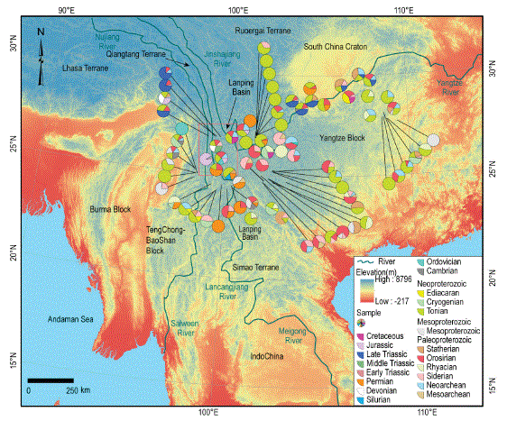
Fig. 1. Ages distribution of detrital zircons from the Lanping Basin and neighbouring areas. Pies with colours mean different peak ages of detrital zircons shown as the legend, and the area ratio of pies show percentage of the peak age in one sample. The position of the pies is where the clastic samples were collected.
Biography:
Lifei Yang is a doctor student at the China University of Geosciences in Beijing (China) at present, graduated with a B.Sc. (2014) from Yunnan University. His research fields include tectonic evolution, metallogenesis and sedimentology of the Sanjiang Tethys, SW China. From now, he has published 6 SCI research papers.
New Oil Generation, Libya
The Ghadamis basin is a large intracratonic sag basin which straddles the boundaries between Libya, Algeria and Tunisia. The Area of study is focused on the BP Blocks in Western Libya.
An Upper Ordovician glaciogenic sequence is present throughout the study area with coarser sediment in the south, which then gradually fine northwards. This facies behavior is interpreted from the well correlations and is mainly attributed to the change in the glacially influenced depositional environments of the area.
Discrete Channelized features trending N-S to NNW-SSE were mapped on 2-D and 3-D seismic data. They are interpreted as glacial palaeovalleys in the south, which developed under an ice sheet in a glacio-continental environment, while in the north they are interpreted as proglacial channels deposited in front of an ice sheet in a glacio-marine environment. These interpretations are based on a comparison with surface outcrop features with similar scales. Seismic characters of the upper Ordovician show dipping reflector geometries and cross cutting relationships with dim and bright amplitudes.
Multiple phases of sedimentary cut and fill within these channels and palaeovalleys are observed on both data bases. These are also seen on the surface outcrop analogous of the Gargaf Arch and are interpreted to occur during multiple cycles of ice sheet advance and retreat.
Glacial palaeovalleys are the main means of sediment transportation during Late Ordovician and they show a northerly trend with their mouths opened to the north.
Biography:
Abdelgader Krnaf received his Bsc in Geology from Garyounis University, Libya in 2007. He worked for pioneer Service and Owner Companies such as Schlumberger, Baker Hughes, Total & BP. He also worked as Geosciences visiting lecturer at Benghazi University & University of Kurdistan, Hawler. He was awarded an Msc in Petroleum Geoscience at Royal Holloway, University of London in 2009. In 2015 was appointed by EAGE and AAPG to Chair sessions at Geoscience workshops and was a member of the third Conference on Iraq technical committee in UAE. Now is Director at NEW OIL GENERATION, Libya, Oman and Czech Republic.
Universiti Malaysia Sabah, Malaysia
This paper focused on efficiency of selective locally isolated beneficial microorganisms (LIBeM) consortium in bioaugmentation of oil sludge contaminated soil in a laboratory scale. Five different selective microbial consortiums LIBeM were obtained from Environmental Microbiology Laboratory, Universiti Malaysia Sabah. The arrangement of aerated static pile (ASP)-bioreactor made up of acrylic materials dimension (60cmx40cmx20cm) was developed with three silicone tubingʼs connected to air pump (Model RESUN lp100 Low Noise Air Pump) act as continuous aeration to the soil. Six different sets treatment containing 10 kg of soil mixed with 20% (v/v) oil sludge were denoted as Consortium 1(P. aeruginosaBAS-Cr1+ S. paucimobilis ReTOS-Cr1+ S. maltophiliaRAS-Cr1), Consortium 2 (C. tropicalis RETL-Cr1+ C. violaceumMAB-Cr1+ S. maltophilia RAS-Cr1), Consortium 3(C. tropicalisRETL-Cr1+ S. maltophilia RAS-Cr1+ P. aeruginosa BAS-Cr1), Consortium 4 (C. tropicalis RETL-Cr1+ C. violaceumMAB-Cr1+ P. aeruginosa BAS-Cr1) consisted with three bacterial strains whereas Consortium 5(ReTOS-Cr1+ BAS-Cr + RAS-Cr1+ RETLCr1+ MAB-Cr1) with five bacterial strains and Control plot (Natural attenuation) consisted of indigenous microbial in the soil as a control plot. The rates of biodegradation of oil sludge were studied for a period of three months and periodic sampling of soil from each bioreactor was carried out at 7 days of interval. Analysis of Total Petroleum Hydrocarbon (TPH) was done along with physiochemical parameters such as pH, moisture content and microbial population (CFUs) in the soil. The results obtained revealed biodegradation of oil sludge contaminated soil in all set treatments were much higher than Control plot (NA) by 12.1 fold. The bioreactor augmented with Consortium 4 proved to be a better performance with 94% of TPH removal followed by Consortium 2 (91.6%), Consortium 5 (90.1%), Consortium 1 (90%), Consortium 3 (87.5%) and Control plot (27.4%) respectively. The variations of physiochemical parameters that influence the reduction of oil sludge in the soil were also discussed in this paper. It was noted that, the continuous supplied of oxygen from aerated static pile (ASP) into the soil showed a good prospects in bioremediation of oil sludge.
Keywords: Bioremediation, Oil sludge, Microbial Consortium, Aerated Static Pile (ASP), LIBeM
Biography:
Dr. Piakong Mohd. Tuah completed her PhD at UTM, Skudai Malaysia in Bioremediation. He completed his MSc. Environmental Biotechnology in Bristol, England in 1997. Now he is working as a Associate Professor at Faculty of Science & Natural Resources, Universiti Malaysia Sabah (UMS) Sabah, Malaysia. From 1981-Jan 1998 he worked as Environmental Health Officer, Ministry of Health Malaysia stationed at Health Office, Kota Belud, Kota Kinabalu, Semporna and Tawau, Sabah assigned to various units: Food Quality Control, Communicable Disease Control, Rural Environmental Sanitation Programme, General Health (includes International Health). Other responsibilities were to perform duties as a Prosecuting Officer under the Food Act 1983 and other respective public health laws in Malaysia. Recipient of the TCP (Technical Co-operation Programme) Scholarship 1993, British Government, U.K. Passed Malaysia Government Laws Examination in 1989.
1British Antarctic Survey, UK
2Universidad Cientifica del Sur, Peru
3University of Tasmania, Australia
4Australian National University, Australia
5Alfred Wegner Institute, Germany
6Bergen University, Norway
7Lyon University, France
Life on the seabed, on continental shelves around Antarctica, can be globally important in immobilizing organic and inorganic carbon. Although their turnover of carbon cycling is low compared with oceanographic carbon storage or water column pelagos (e.g. zooplankton), the storage, burial and thus potential for sequestration is high, but little understood or quantified to date. Carbon storage by benthic animals around West Antarcticaʼs continental shelves, estimated at 106 tonnes per year, has increased in response to climate change and shows seasonal, annual and between-region variation. Quantifying this variation should reduce error in CO2 pathway models. SubAntarctic island shelves are likely to be even more important benthic carbon stocks because of more considerable phytoplankton blooms, little or no sea ice and warmer sea temperatures than Antarctica (enabling faster meal processing time, and thus growth rates by benthos). Their potential as a carbon sink is almost unknown but new projects on the Antarctic Circumnavigation Expedition (ACE) and ICEBERGs have been sampling these shelf benthos using bespoke camera landers, video and photo-equipped trawls and cores. These are enabling estimation of changes in intra and inter-shelf variability in benthos carbon storage. Growth models constructed from age structure of sampled species with growth check lines (e.g. bryozoans, bivalves, brachiopods and corals) enable carbon accumulation to be estimated across seasons and years. We are constructing seabed carbon capture and storage budgets in a rapidly changing part of the world that may represent one of the most important global negative feedbacks on climate change.
Biography:
Dr. David Barnes is a marine ecologist at British Antarctic Survey, NERC and teaches at the University of Cambridge (UK). He has worked in polar marine science, focusing on continental shelf benthos, for 27 years and has published 240 scientific papers. Most recently, he is working on quantifying blue carbon in cold waters, itʼs tempero-spatial variability and power as a negative feedback on climate change – on the Antarctic Circumnavigation Expedition and NERC
Consultants GeoEnvironment, Australia
Environmentalists are not the only ones stressing the realities of climate change; the effects can be seen in the political, economic and social behaviour of the country.
Political issue: polarization noted in the views of Australian public. Main parties in Australia have different opinions but now general public is more aware of climate change.
Economic issue: Small farmers felt the effects; agriculture sectors covered 61% of Australia. Climate change has worsened the matters related to farmers. Changes in production patterns due to higher temperatures, extreme and changing precipitation patterns threaten crops. This affects food supplies and increase volatility in food prices. The low cost greenhouse is design to help the poorest farmers.
Rural and urban poor are the hardest hit: We are trying to improve poverty and inequality for decades, which will get worse with climate change. No resources to cope with the effects of extreme flooding or droughts will only displace or change the way of life of the disadvantaged. Australia provides monetary help to poor at the time of need; the best is to prevent such needs.
Social issues: Women, children, and the elderly will become even more vulnerable from climate change. It will increase the amount of work load for women and heat related ailments will be increased in elderly and children. Fortunately the medical system in Australia provides a lot of help.
Communities will be forced to relocate as they are exposed to rising sea levels, drought puts strain on resources and extreme rainfall becomes the norm.
Biography:
Dr. Ayesha Saeed is a geoscientist with expertise in geochemistry. She is from Sydney Australia. She did MSc Geology (Pakistan), MSc thesis on Murry Basin Australia (University of NSW), PhD in geochemistry (Auckland University, New Zealand). She spends a decade in research related to exploration of mineral and precious stones using state of the art techniques at Macquarie University, Australia. In the last five years she changes her focus and utilizes her expertise for improving climate and environmental conditions. She worked with Pakistani Universities targeting alternate energy options. And now involved in environment related projects and products.
University of Alaska Fairbanks, USA
When constrained by subsurface boundaries such as permafrost, clay, or bedrock, drainage water flows through the soil, channelizing into features known as “water tracks”. Water tracks indicate an immature hydrological network and are widely found in the Arctic and Sub-Arctic due to the prevalence of permafrost. Despite their abundance, there is a lack of understanding of water track characteristics and their interplay with the surrounding bio-geophysical environment. In addition, water track impacts on the northern landscapes due to the warming climate makes it critical to study. An observed impact is increased subsidence with the progress of water track. Another major cause of soil subsidence in the Arctic is soil piping. Soil piping could be induced due to geology, slope, soil texture, hydraulic and thermal properties, and frost. The interaction of water tracks with soil pipes have caused significant subsidence in Martinsʼ property near Fairbanks, Alaska. These subsidence patterns have progressed steadily and rapidly to threaten the foundation of their house. Hence, the first objective of our study is to examine and characterize the interplay between soil pipes and water tracks to assess the factors that are responsible for soil subsidence. We have collected soil temperature, moisture, and intrinsic permeability data along and across a prominent water track and a few soil pipes in Martinsʼ property. We have used thermal infrared images over a period of time to study the changes in thermal regime of the water track and the soil pipes. We have mapped the geology of the area using well logs to assess the role of geology and slope. Our second objective is to develop a method to map existing water tracks on Goldstream Road near Fairbanks to investigate whether it intensifies the road damage when the flow in water tracks is blocked by the road foundation. Goldstream Road is known to have extensive and recurring damage, some of which are likely amplified by water track interceptions. Mendbayar et al. (2016) have observed water tracks intercepting the road and have collected soil temperature and hydraulic data at one water track crosscut by Goldstream Road. Geophysical data along the road have been procured in 2012 and 2016 by state agencies. However, no method is existent in mapping such narrow water tracks in densely vegetated areas. We used a DEM from a high-resolution aerial photograph to correlate it with the geophysical and hydraulic data. We mapped vegetation index around Goldstream Road using high-resolution satellite imagery to identify water tracks that influenced moisture availability to plants. Climate change may have induced both of these scenarios but the two case studies are still in progress, and we will present the progress and conclusions drawn from our study thus far.
Biography:
Debasmita (Debu) Misra was born in the state of Odisha in India. He completed his B. Tech. in Agricultural Engineering in 1984 from India and M. Eng. in Water Resources Engineering in 1986 from the Asian Institute of Technology (AIT). After a year of graduate studies in Engineering Hydrology at the University College Galway, Ireland, he joined Ph.D. at the University of Minnesota in 1988 in the field of Biosystems and Agricultural Engineering, which he completed in 1994. He is currently a Professor of Geological Engineering at UAF. He teaches undergraduate courses in subsurface hydrology, remote sensing for engineering, senior design and graduate courses in unsaturated or saturated groundwater flow and contaminant transport in subsurface. His research is focused on non-isothermal fluid dynamics in soils and its impact on transport processes.
1Indian Institute of Tropical Meteorology, India
2Central University of Jharkhand, India
“Geoinformatics” is an interdisciplinary branch, encompassing the latest technologies with the most dynamic & innovative tool for mapping, monitoring, modelling, assessment and defensible management of various environmental issues and natural resources by its specific capabilities and cost effectiveness. It basically utilizes an integration of Remote Sensing (RS), Geographical Information System (GIS), and Global Positioning System (GPS) & also Information Communication Technology (ICT) and other social interactions. Through Geoinformatics, we can study the Earthʼs environment as well as its changing trends over the years. This technology can play a vital role in monitoring the land use & land cover (LU/LC) over a particular region and can help to estimate the LU/LC changes over the years, using spatio-temporal data. In this study, the LU/LC change analysis has been done for Vishakhapatnam port ( and its neighbourhood), situated in the Eastern coast of India, over a period of 30 years, with 4 time slots (1988, 1997, 2009 & 2017) during 1988-2017. LU/LC variation due to several features, like human settlement, forest cover, water bodies, vegetation, fallow land, sediments etc. in the coastal areas of Vishakhapatnam & nearby regions have been estimated for the above years (1988, 1997, 2009 & 2017) using USGS data and specific software. This study wished to delineate the flood risk assessment at Visakhapatnam port using Geoinformatics technology and satellite imageries. Shoreline changes and sea level rise in the coastal areas of Vishakhapatnam during the above period have been studied, as these are important for flood risk assessment over the vulnerable areas. From the analysis of sea level rise, it was inferred that the sea level has increased and the shoreline has deviated over the years. By the help of flood mapping through Remote Sensing and GIS, it can be inferred that the Visakhapatnam port areas have been highly prone to flood during recent times. Vishakhapatnam experienced Hud-Hud cyclone in October 2014 and also flood conditions (due to heavy rainfall) in September 2016. These severe events affected the port as well as city areas and there were loss of life and huge damage to properties. These raised the need to address flood related problems through scientific planning, based on studies and detailed researches on extreme weather events and climate change impacts over flood prone areas for formulating possible mitigation measures. In the present study, flood risk assessment shows that a major part of Visakhapatnam port areas fall under medium to high risk zone. Hence, proper coastal management is required for this port.
Biography:
Somnath Mahapatra is a senior Scientist, associated with Monsoon Mission program and the International CLIVAR Monsoon Project Office (ICMPO) at IITM (Indian Institute of Tropical Meteorology), Pune, India. His area of interest includes Numerical Weather Prediction, air-sea interactions, coupled oceanatmosphere dynamical modelling, climate variability & change, etc. and he published papers in these fields. He contributed for implementation of Monsoon Mission program for improving prediction skill of Indian Monsoon by a coupled dynamical model. He has been active in various activities of Indian Meteorological Society. He is an adjunct faculty of DASS, S. P. Pune University for teaching their post-graduate students. He guided several post graduate students for internship training & project works. He has participated & organized several National & International events (Symposia/ Conferences/ Workshops/meetings/trainings) at IITM, Pune. He likes to share his knowledge through Science popularization and outreach programs.
Contact us for any additional information - contact@madridge.org
 Madridge Publishers is licensed under a Creative Commons Attribution 4.0 International License.