
1Melnikov permafrost institute SB RAS, Russia
2University of Warsaw, Poland
The paper considers periglacial sediments within Abalakh high accumulative plate (AHAP) in Central Yakutia. This territory occupies Lena-Amga interfluve. In borehole 18/1 five Complexes (I-V) of sediments was recognized: alluvial in the bottom (Complex I), overlaying by alluvial-lake sediments (Complex II), lake (Complex III) and Ice Complex (Yedoma) ((Complex IV). The top of sediment succession is occupied by the Holocene deposits (Complex V). Micromorphology of quartz sand and silt grains analyzed in scanning electron microscope (SEM) and mineralogical analyses were introduced to reconstructed accumulation conditions, influence of periglacial conditions and source of sediments. Based on the obtained results, it can be concluded that the accumulation of deposits of the Complex I took place as a result of multiple retransporting of the same material and a limited supply of new material in a fluvial environment. Up the profile, the activity of fluvial processes decreased in favor of lake accumulation. Syngenetically frozen ice-rich silty deposit (Yedoma, Ice Complex) of the Complex IV is made of grains with a precipitated surface, but with a different degree of crusting and mineralogical different from the deposits lying below. Aeolian processes are responsible for their transport. They are a compilation of a variety of sediments, including supply older sediments, including retransported loess and mechanical weathering took place in parallel with sediment accumulation.
Biography:
Anna Kut, PhD, researcher of the Melnikov Permafrost Institute (Yakutsk, Russia). Key points of studying is reconstruction of sedimentation environment of the Ice Complex sediments within Central Yakutia and Arctic region and frost weathering processes in sediments in the Pliestocene and Holocene sediments and its regional manifistation. Using method is morphoscopy analyze is based on the roundness degree and frosting of quartz grainʼs surface rating.
1Centre of Environmental Sustainability & Water Security (IPASA), Research Institute for Sustainable Environment (RISE), Universiti Teknologi Malaysia, Malaysia
2Department of Water & Environmental Engineering, School of Civil Engineering, Universiti Teknologi Malaysia, Malaysia
3Centre for Coastal and Ocean Engineering (COEI), Universiti Teknologi Malaysia, Malaysia
4Department of Chemistry, Faculty of Science, Universiti Teknologi Malaysia, Malaysia
5Ecohydrology Research Institute, The University of Tokyo Forests, Graduate School of Agricultural and Life Science, The University of Tokyo, Japan
Land-disturbancessuch as logging lead to major, but short-lived increase in erosion (~2years) until revegetation of slopes occur. Such vegetation isknown to offer protection against erosion. This paper questions and re-assesses thishypothesis using the Modified Laser Erosion bridge method in a gradient of land-disturbance from near pristine to Oil palm and rubber plantations (with bench-terraces), which has greatly expanded in recent decades.Additionally, this study seeks to determine contamination by selected metals (Mn, Cd, Cu, Pb, Ni and Zn) in both water and sediment within the Kelantan River Basin, West Malaysia. Geo-accumulation Index, (Igeo), Pollution Load Index, (PLI) Enrichment Factor (EF) and Potential Ecological Risk (PE) assessment were applied to assess heavy metal contamination in sediment samples. Soil erosion rates were measured and monitored from March 2017 to February 2019 at five different sites: a) high conservation value forest (HCVF), b) logged forest (LF), c) 10-years-old mature oil palm plantation (MOP),d) Newly planted oil palm (NOP) and e) 13-years-old mature rubber plantation (MR). NOP showed the highest erosion rate at 92.2 t ha-1yr, followed by HCVF (63.3 t ha-1yr-1), MOP, LF and MR (43.8, 42.4 and 5.9 t ha-1yr-1 respectively). Mn in both water and sediment was 0.0376-10.2031 mgL-1 and 7.977-17684.673 mgkg-1, respectively. Igeo indicated that sediment samples from most stations were slightly polluted (grade 1). EF value for Pb was the highest in most stations. Heavy metal concentration in water was compared against the National Quality of Water Standard Malaysia - most of the elements in each station were below the maximum permissible concentration for Class IIA/IIB except for the Mn in Aring, Chalil, Pahi and Krai; and Cu in Koh. This paper summarised the key findings to date - focussing on differences in erosion rates and sediment and water quality, with regards to heavy metal contamination.
Keywords: Erosion, Oil Palm Plantation, Rubber Plantation, water quality.
1Plano ISD Academy High School, USA
2University of Texas at Dallas, USA
Recent studies in Texas and Arkansas have demonstrated a link between groundwater in the Carrizo-Wilcox Aquifer that has been in communication with low-rank coals and a degenerative kidney disease resulting in dialysis treatment (End Stage Renal Disease, referred to here as the Lignite-Water Syndrome). This relationship was first noted in Eastern Europe where it was called Balkan Endemic Nephropathy. The Carrizo-Wilcox Aquifer and associated low-rank coals extend into northwest Louisiana. A detailed analysis of dialysis patents on a zip-code level indicated that the people living in this region have a substantially higher incidence of patients on dialysis than does the rest of the state (27.78/10,000 vs 21.24/10,000). Neither ethnicity nor age appear to be confounding factors. Data for six of the eight Parishes (Bossier, Caddo, De Soto, Natchitoches, Sabine and Webster) that produce Carrizo-Wilcox water for human consumption show that the incidence of dialysis treatment jumps to 51/10,000, a statistically significant 2.5 times the average of the rest of the state. This ratio is the same as the ratio found in Texas and North Dakota for dialysis patients in the regions underlain by low rank coals versus non-coal regions. The data indicate that the health of as many as 40% of the dialysis patients in northwest Louisiana have been impacted by drinking water from the Carrizo-Wilcox Aquifer.
Cairo University, Egypt
Integrated induction electromagnetic, electrical and ground penetrating radar surveys were carried out in highly intruded site by sea water at the northwest coast of Mediterranean Sea, Egypt, to assess the shallow subsurface stratification, cracks, faulting, or any unexpected subsurface criterion that can affect the sustainability of the construction of a new water plant. The applied geoelectrical resistivitysounding (ER), which can be utilized for investigating the vertical and lateral variation of resistivities of subsurface geological sequence, supportedwith the additional information gathered from GPR andVLF-EM techniques and correlated and validated with the referenced subsurface geological sequence and the drilling boreholes.
Applying VLF-EM and ER techniques reveals the geology of the subsurface up to 120 meters from the ground surface in the form of four-distinctive-layers model of: surficial moderately-resistive alluvial deposits with a thickness varies between 5 – 8 m; second layer of highly-resistive calcareous sandy mud deposits with a thickness ranged between 10 – 22 m, third layer represented by highly saline saturated oolitic limestone with a thickness ranged between 60 – 72 m and the imaged succession was ended with highly-resistive marly limestone with clay intercalations. Whereas, ground penetrating radar supported the near-surface subsurface sequence.
The integration of the VLF-EM, ER and GPR results generated well-established and trustable subsurface geological model and There is no indication for the presence of subsurface abnormalities in the investigated site, that can affect the stability and sustainability of the proposed new water plant, taking into account the extreme degree of saline saturation due to the closeness of the site to the Mediterranean Sea
Biography:
Essam Abdel Halim Morsy is an associate Professor in Environmental and Applied Geophysics Department, Faculty of Science, Cairo University where he has been a faculty member since 1996. He completed his undergraduate studies, M.Sc and Ph.D degrees at Cairo University. His research interests lie in the area of application of near-surface geophysical techniques in solving the environmental and engineering problems, ranging from theory to design to implementation. He has collaborated actively with researchers in several other disciplines of environmental science, particularly air quality and solid waste management.
Department of Earth Sciences, University of Turin, Italy
Debris flows are one of the most dangerous and destructive natural process due to their unpredictability, their extremely high motion and their magnitude. Mitigation measures are fundamental for reducing the associated risk and protecting infrastructures in mountainous areas.
However, their design is still an open issue: there are many formulations to evaluating impact pressure and the uncertainties in the determination of flow characteristics (velocity and thickness) are significantly high and difficult to quantify. In the European Union, the design of any type of structures involved in rock mechanics field must comply with EN-1997 Geotechnical Design (CEN 2004) (EC7). For debris flow countermeasures, EC7 requirements are very difficult to apply in practice since partial safety factors are not provided for these phenomena. However, the basic philosophy of reliability-based design (RBD), as defined in EN1990 (CEN 2002) may be a suitable and complementary approach to provide geotechnical structures with a uniform probability of failure. Reliability Based Design (RBD) can provide additional insights to EC7 design and can be applied when partial factors have still to be proposed (by EC7) to cover uncertainties of less common parameters, as in case of debris flow countermeasures.
Biography:
Federico Vagnon obtained his masterʼs degree in environmental engineering in 2013 at the Politecnico di Torino. In 2014 he won a grant for a Ph.D position at the Department of Earth Sciences of the University of Turin and in 2017 he obtained his Ph.D degree with a thesis entitled: “Theoretical and experimental study on the barrier optimization against debris flow risk”. He is currently a research fellow at the same department. He is author of about 25 scientific paper on topics related to Geotechnics, Rock Mechanics, Engineering Geology and Geophysics.
1Sultan Qaboos University, Oman
2King Abdulaziz University, Saudi Arabia
Floods are a major risk in many parts of the world, leading to many risks to life in different fields. The use of modern technologies such as Geographical information system (GIS) reduces the harmful effects of these floods and manages the flood disaster. With the technological development of this age, the use of these techniques is becoming available, as using geographic information systems leads to positive results in managing flood crisis and reducing damage. This study applied Geographical Information System Technology in the spatial analysis of flood risks in East Nile District, Khartoum State, Sudan; using geospatial technologies.
Keywords: Flood Hazards; GIS
Biography:
Rifaat Abdalla received his Ph.D. degree from York University, Canada and MASc from the University of Regina, Canada. His experience is in diverse professional, research and teaching environments; including DRDC, the Federal Government of Canada research arm in National Defence and York University, where he spent four years as a Tutorial Leader and served as Adjunct Faculty afterwards. He was also employed by the Geological Lab of the Provincial Government of Saskatchewan. Prior joining Sultan Qaboos University (SQU) in 2017, he served for five years with King Abdulaziz University in Saudi Arabia for two terms between 2006-2008 and 2013-2017. Dr. Abdalla has worked for the industry in various capacities from entry level to senior consultant. Dr. Abdalla is an active professor, interested researcher and eager professional combining multiple career paths.
1Nature research centre, Lithuania
2Lithuanian Geological Survey, Lithuania
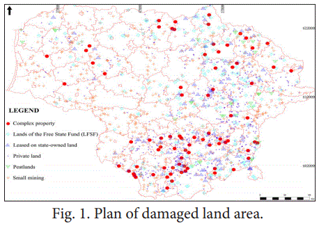
As the depths of the earth are mineral resources, their extraction is a significant economic indicator of the countries. Planned, supervised and orderly mining of useful resources is a routine process with minimal impact on the environment and excavation increasing each year. As demand increases, so does illegal and disorderly mining sites, which causes significant damage to the environment and the economy. Using aerial photography technology, illegal mining sites have been calculated throughout the territory of Lithuania and quantities have been excavated over 20 years. . The Lithuanian Geological Survey performed the State Damaged Land Management Plan 2014-2020 approved by the Minister of Environment and carried out an audit of all Lithuanian cadastral damaged areas of more than 0.3 ha - “Collection and systematization of information on damaged lands” [1]. The purpose of this project was to identify the sites and condition of the land damaged by any mining operation; to calculate excavated mineral resources; to accumulate and systematize information on damaged lands and based on the collected data to identify the damaged lands to be treated first. The results of this work showed that 3300 sites of more than 0.3 hectares are affected by casual damage (fig. 1). The damage done to the country's economy and environment has been assessed. The estimated amount of minerals extracted is 15 million cub. m. and amounts to about 70 million euros in damage. Aerial photography technology has proven its worth in calculating excavated resources and can be used for monitoring.
Biography:
Audrius Armanavicius is a 3rd year doctoral student of Geology Science from Lithuania at the Nature Research Centre. His specialization is mineral deposits, their exploration, quarry design and monitoring using aerial photogrammetry technologies.
Contact us for any additional information - contact@madridge.org
 Madridge Publishers is licensed under a Creative Commons Attribution 4.0 International License.