
Review Article
Prospection techniques for Oil and shale gas
ISEL-ADEM, Street Conselheiro Emidio Navarro, 1, 1959-007 Lisbon, Portugal
*Corresponding author: Nuno Domingues, ISEL-ADEM, Rua Conselheiro Emidio Navarro, 1, 1959-007 Lisbon, Portugal, E-mail: nndomingues@gmail.com
Received: December 11, 2018 Accepted: January 24, 2019 Published: January 30, 2019
Citation: Domingues N. Prospection techniques for Oil and shale gas. Int J Petrochem Res. 2019; 3(1): 243-248. doi: 10.18689/ijpr-1000142
Copyright: © 2019 The Author(s). This work is licensed under a Creative Commons Attribution 4.0 International License, which permits unrestricted use, distribution, and reproduction in any medium, provided the original work is properly cited.
Abstract
Portugal is under an intensive foreign interest in exploration for oil and shale gas. The interest is onshore and offshore. There are several contracts signed for prospection by fracking. After the developments in Algarve area in October, the focus is now on the triangle formed by Figueira da Foz, Peniche and Fatima Shrine. Citizens are divided, but many assume that knowing the endogenous energy potential can be positive to reduce external dependency, security of supply and increase exports. The main general concern is the Environmental and Social impact of the prospection based on this method.
This paper presents and reflects on alternatives for the fracking technique. There are several alternatives of the fracking technique that can be considered when prospecting in populated areas, such as inside rural areas. Also, these techniques can be considered in areas with economic activities based on water consumption, such as agriculture and fishery. These techniques have greater respect for the population and their activities. The incremental costs of such alternatives are not so high that could jeopardize profits for companies. Also, these techniques donʼt delay in time the projected works.
Keywords: Oil and shale gas; Fracking; Oil and gas exploration; Gravimetry.
Introduction
In September 2015, the Government and the Australis Oil and Gas Company signed the contract for research and production of oil in the triangle formed by Figueira da Foz, Peniche and Fatima Shrine. The municipalities of Pombal, Soure, Leiria, Marinha Grande, Batalha, Nazaré, Alcobaça, Porto de Mós, Caldas da Rainha, Ourem and Rio Maior are of interest to the oil and gas exploration. It is allowed for eight years and anticipated an investment of 10,225 million euros and if there is production, the operating contract is for 25 years, with extensions up to 15 years. These holdings comprise several lots of contiguous land and cover the district of Coimbra, Leiria and Santarem between the Mondego estuary, by the municipality of Ourém to Fatima Sanctuary and inclusive. The contracts provide that Portugal will receive royalties (exploitation rights) in the total amount of 1,5 to 8% of the total withdrawn barrels, but there is a clause that conditions the payment: Only when the Australis company find the concession investment was recovered [21].
The report submitted by the Australis to National Entity for the Fuel Market (ENMC) [1], the National body for the Fuel Market, claims that there are large gas accumulations. Although the operation may be limited, the tests show there is an active hydrocarbon system. There is gas in volume and there is a gas pipeline with installed capacity to receive more production. In addition, there is a modern road system for distribution. The domestic market depends exclusively on imported oil and gas and there are no restrictions on exports, but a beneficial tax regime [8].
The Australis submitted the proposal to investors on November 6th, 2018, and highlighted the low cost of ownership in land area with minimal need for hand labour and the absence of government participation in the process. Thus, it is evident the uncertainty of job creation and the certainty of no government bureaucracy.
The ENMC updated the map of licenses and concessions for oil prospecting and production in Portugal, where four contracts were cancelled in the Peniche Basin [1].
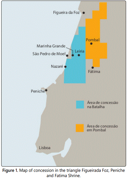
The rights to concession area of research, development and production of oil is illustrated in (Figure 1) [1]. If authorized, a prospecting hole with 3200 meters vertically and between 300 and 700 meters in the horizontal must be performed in the next two to three months (until March 2019) and involve up to 50 workers.
In the area of Marinha Grande, beyond the coastal strip exposed to offshore contracts, there are still areas contracted onshore contract called ‘Battle’. On land, fouled The Possibility of conventional oil production, it is expected to further production of shale oil and gas, just in hydraulic fracturing techniques fracking.
The first holes of exploration and possible exploitation will start in 2019 in Aljubarrota (Alcobaça).
The authorization to Australis operate was given by ENMC and the Portuguese Environment Agency (APA) that will assess if an environmental impact assessment is required.
Shale gas is natural gas that is inside of the porous type of sedimentary rock called shale. It has the same chemical composition of the oil, but itʼs casing and production method is different. The contracts signed are also for shale gas exploration [21, 23-30].
Techniques for oil and gas prospection
Generality
One of the biggest concerns of citizens, social entities and environmental organizations is the impact of fracking technique. The exploration of oil is one of the stages that precede its exploration and it is at this stage that the use of fraking is foreseen. The achievements of several studies are necessary in order to identify whether or not a given region contains a useful accumulation of fossil fuel, and thus to advance in its exploration. Thus, this study is important for the country [31].
There are alternatives to fracking to determine the auspicious conditions of crude oil and natural gas, which may be geophysical or geological. In the area of geophysics, electrical, gravimetric, sonic, seismic, magnetic, imaging and resonance methods can be performed, offering specific data and quality. These methods are responsible for detecting the presence, position and organization of sub-surface geological structures.
The various methodologies aid in oil exploration that can increase the reliability of drilling. However, confirmation of reservations is only possible with the drilling of the well. Thus, the prospect is a way to reduce gaps and uncertainties during exploration wells, and the wells thus reducing ensuring exploration and reduced environmental impact.
Traditional methods
The geophysics is the study of Earth using measurements of its physical properties, as show in (Figure 2) [2].
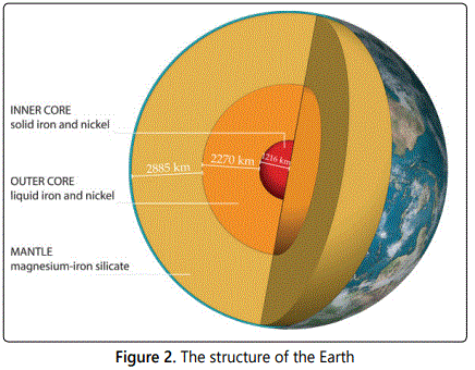
Geophysical acquire, process and interpret the data collected by special instruments such as the purpose of obtaining information on the structure and composition of the rocks in the subsurface. Much of the knowledge acquired about the interior of the Earth, beyond the limits Reached by wells, comes from geophysical observations. Also initially this knowledge was used for the activity of oil exploration. The Gravimetry and magnetometry, also called potential methods were very important at the beginning of oil exploration by indirect methods, allowing the recognition and mapping of geological structures major that did not Appear on the surface [5][7][11].
Geological methods
The first stage of an exploratory program is to conduct a geological study with the purpose of reconstituting hydrocarbon formation and accumulation conditions in a given region. The geologist prepares surface geology maps from the surface maps and well data, as well as analyzes the paleontological and geochemical information.
Surface
Through the mapping of the rocks that appear on the surface, it is possible to recognize and delimit the sedimentary basins and to identify some structures capable of accumulating hydrocarbons. The geological and geophysical information obtained from exploratory wells is of great importance for the exploration, since they allow to recognize the rocks that do not surface in the surface and to gauge and to calibrate the indirect processes of researches as the seismic methods.
It consists of the study of geological data obtained in an exploratory well. From these data it is possible to determine the geological characteristics of the sub-surface rocks. The most common techniques include:
- the description of rock samples taken during drilling;
- the study of the drilled formations and its depth in relation to a fixed reference (sea level often);
- the construction of maps and structural sections by correlating information from different wells;
- the identification of fossils present in rock samples from the surface and subsurface through the paleontology lab.
With the results obtained it is possible to correlate the most varied types of rocks within a basin or even between basins.
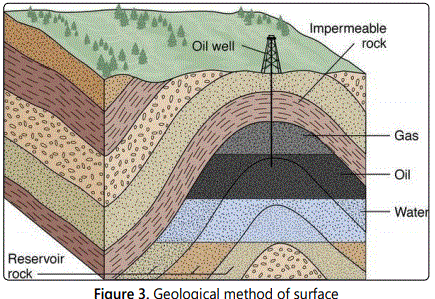
The geologist works on the direct calibration of the rocks and, using different techniques, can identify the most promising structures for the accumulation of oil in an area [5] [7]. The geological method of surface is shown in (Figure 3) [32].
Aerial
It can be of two types: Aerophotogrammetry and photogeology.
Aerial photogrammetry is fundamentally used for the construction of base or topographic maps and consists of photographing the terrain using a suitably equipped airplane, flying with constant altitude, direction and speed.
Photogeology consists of the determination of the geological features from aerial photos, where folds, faults and the diving of the geological layers are visible. Geological structures can be identified by varying soil color, river configuration and drainage in the study region.
In addition to the aerial photos obtained in aerophotogrammetric surveys, radar images and satellite images are used, whose colors are processed to highlight specific characteristics of rocks exposed on the surface.
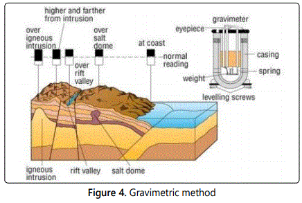
Gravimetric
It is now known that the gravitational field depends on five factors: latitude, elevation, topography, tides and sub-surface density variations. The latter is the only one that is interested in the gravimetric exploration for petroleum, since it allows to estimate the thickness of sediments in a sedimentary basin, the presence of anomalous rocks such as igneous rocks and salt domes, and to predict the existence of structural ups and downs by unequal lateral distribution of sub-surface densities.
The unit of measurement of the acceleration of the terrestrial gravitational field is the Gal in homage to the Italian physicist Galileo Galilei (1564-1642), and is worth 1 cm / s2. The average acceleration at the Earthʼs surface is 980 gal (increases 0.5% from Ecuador to the poles) and the anomalies produced by geological structures of interest to the prospecting of oil are of the order of 10-3 gal. Gravimeters are very sensitive measuring instruments, they must be accurate to the order of 1 / 1,000,000.
The gravimetric map obtained after the application of the corrections of latitude, elevation, topography and tides is called Bouguer map, in homage to the French mathematician Pierre Bouguer (1998-1758). The interpretation of the Bouguer map is ambiguous, since different geological situations can produce similar gravimetric profiles. Therefore, the individual use of the gravimetric method cannot reliably diagnose the real structure of the Earthʼs interior, even though it may show some kind of anomaly. However, when used in conjunction with other geophysical methods and previous geological knowledge of the area, it allows a significant advance in the understanding of the spatial distribution of rocks in sub-surface.
When they search for fossil fuels at sea, petroleum geologists employ special sniffing equipment that detects traces of natural gas in seawater. But because this method only helps locate leaking deposits, large oil companies rely on two other methods to locate deposits [5] [33].
When near the surface, certain rocks affect the Earthʼs magnetic field. Using magnetic survey equipment, a ship may pass over an area and map any magnetic anomalies it may encounter.
The Gravimetric method is shown in (Figure 4) [31].
Magnetometric
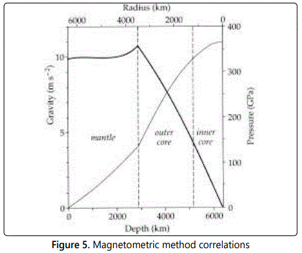
Magnetic prospecting for petroleum aims to measure small variations in the intensity of the earthʼs magnetic field, as a consequence of the irregular distribution of magnetized rocks in sub-surface. In the aeromagnetic surveys the measurements obtained by the magnetometers depend on several factors, such as: latitude, flight altitude or elevation, flight direction, diurnal variations and localized presence of rocks with different magnetic susceptibilities. Diurnal variations are used by solar activities, called magnetic storms, and by the movement of ionized layers in the upper atmosphere that act as electrical currents disturbing the Earthʼs magnetic field.
The unit of measure in magnetic surveys is the gamma, or nanotesla, that is worth 10-5 gauss, unit defined in homage to the German mathematician Karl F Gauss (1777-1855). The Earthʼs magnetic field is of the order of 50,000 gammas and the anomalies of interest in the prospecting of oil are of the order of 1 to 10 gammas. The magnetometers must have a sensitivity of 1 / 50,000 [5]. The Magnetometric method is shown in (Figure 5) [5].
Seismic
The seismic refraction method records only refracted waves with critical angle and has great application in the area of seismology. It was through this method that the inner structure of the Earth was unravelled, although this method was widely used in the 1950s as support and refinement of the results obtained by the potential methods.
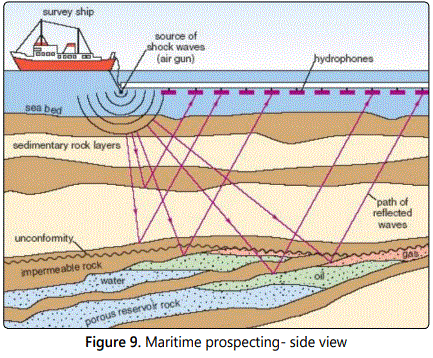
The seismic reflection method is the most widely used prospecting method in the petroleum industry, since it provides a high definition of geological features in a sub-surface area conducive to the accumulation of hydrocarbons. More than 90% of the prospecting investments are applied in reflection seismic. The seismic survey begins with the generation of elastic waves through artificial sources that propagate through the Earthʼs interior, where they are reflected and refracted at interfaces that separate rocks from different petro physical constitutions, and return to the surface where they are captured by sophisticated recording equipment. The method, known as sparking, involves the sending of shock waves through the water and onto the ocean floor. Sound travels at different speeds through different types of rocks. If the shock wave locates change in the rock layers, it returns and is picked up by hydrophones that the research vessel trawls through the water in its wake. With the help of computers, seismologists can analyze the information and locate possible traps.
Research vessels use air cannons and explosives to cause shock waves. Between the two methods, cannons cause fewer threats to marine wildlife, but even acoustic pollution poses a threat to animals with a seismic sense as acute as blue whales, a species at risk.
In seismic surveys, a shock wave is created by the following:
- Compressed air cannon - shoots pulses of air in the water (for exploration over water);
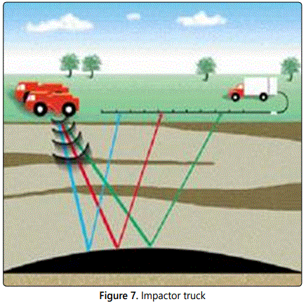
- Truck impactor - heavy plate strikes the ground (Figure 7) (for exploration over land);
- Explosives - buried in the ground (for exploration over land) or thrown overboard (for exploration over water), and detonated.
Shock waves move below the surface of the Earth and are reflected by the various rock layers. The reflections move at different speeds depending on the type or density of the layers of rock they must pass through. Shock wave reflections are detected by sensitive microphones or vibration detectors: hydrophones on the water or seismometers on the ground. The readings are interpreted by seismologists for evidence of oil and gas traps.
figure 6[3] shows the Compressed air cannon technique.
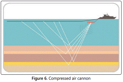
Figure 7. [4] shows the Impactor truck technique.
Although modern oil exploration methods are better than previous ones, they may still have a success rate of 10% for locating new oil fields. Once an impact with oil prospect is found, the location is marked by GPS coordinates on the ground or by buoys marking on the water [9-14].
Prospective drilling
Even if you send sound waves of shock across the ocean floor all day, the time will come when you will need to dig a little if you want to determine the presence of exploitable oil. To take care of the task, the oil companies send a mobile prospecting platform to carry out prospective drilling at the site. Some of them are installed in ships, others have to be towed to the place by boats.
A prospective drilling rig typically digs four prospecting wells at the site of an alleged deposit, each requiring 60-90 days of work. Geologists initially excavate to obtain a core sample. The principle is similar to that of stuffing a hollow tube into a birthday cake and removing it. It would be possible to examine the cylinder and find out what the different layers of the cake are made of. This is a way to find out without cutting a slice.
Petroleum geologists are looking for signs of oil, which they call the show. As soon as they discover a show, drilling stops and geologists conduct additional tests to ensure that the quality and quantity of oil available justify additional work. If so, they dig additional wells to substantiate the findings.
Once geologists establish the value of an oil deposit, itʼs time to dig a production well and start extracting wealth. An average well lasts for 10 to 20 years before it ceases to be profitable, so offshore rigs are built for long stays. They are usually fixed directly to the ocean floor by metal or concrete foundations and mooring ropes. They need to be as stationary as possible during drilling, no matter the weather instability.
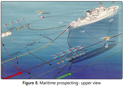
Maritime Prospecting
From Peniche to Figueira da Foz it is necessary to do the maritime prospection to evaluate the offshore potential. The challenge in marine drilling is to transfer all of the oil and natural gas from point A to point B without losing it and without polluting the ocean. How to excavate a tunnel to the bottom of the Earth without it being invaded by water or oil escaping to the sea?
figure 8 [34] and figure 9 [34] show the maritime prospecting from two different views.
To ensure correct drilling, engineers connect the excavation site to the platform by means of a marine excavation mold. Although the shape may vary depending on the exact conditions of the ocean floor, the drilling template basically represents a large metal casing with holes that mark the location of each production well.
As production wells often need to descend miles through the Earthʼs crust, the drill consists of multiple excavation tubes with a length of nine meters, which are screwed together and form a drilling assembly. A turntable allows rotation of the drill assembly and, at the opposite end, a drill crushes and penetrates the Earthʼs crust. The tip consists of a simple drill bit provided with industrial diamonds or a trio of interlocking bits provided with steel teeth. Between the platform and the ocean floor, all the equipment descends by a flexible tube known as a maritime elevator.
As the excavation hole deepens, the operators send a steady stream of prospecting mud through the excavated channel in the direction of the drill bit. Then, the sludge returns to the platform. The thick fluid consists of clay, water, barite and a mixture of specialty chemicals. The drilling mud lubricates the drill bit, seals the well walls and controls the pressure inside. In addition, as the drill shatters rocks, the resulting fragments are suspended in the sludge and leave the well with reflux. On the surface, a circulation system filters the sludge before sending it back down the well.
The drilling process takes place in phases. The initial surface hole, about 45 centimeters in diameter, extends from a few hundred to a few thousand meters. The engineers then remove the drill assembly and ship hollow segments of metal pipes known as casing. Once the coating is cemented in place, the lead pipe lines the hole and prevents it from collapsing and leaking. In the next phase, a 12-cm drill digs deeper. Then the drill assembly is once again coated and the surface coating is installed. The final section, or bottom hole, is coated with an intermediate coating. Throughout the process, an apparatus known as a compactor runs through the well, expanding against the walls to ensure that the entire path is sealed [15-20].
Conclusions
The exploration activity is important for a country meet its energy potential. The identification of the favorable oil accumulation area is performed using geological and geophysical methods. The program developed during the exploration phase provides a large amount of technical information facilitating the mapping of geological structures which might encourage the hiring of a wildcat well. There are several isolated or combined techniques that allow the prospect to lower social interference and environmental impacts. These techniques donʼt require additional time to execute and donʼt introduce significant costs to the overall works. There are available techniques that can be used onshore and offshore.
References
Contact us for any additional information - contact@madridge.org
 Madridge Publishers is licensed under a Creative Commons Attribution 4.0 International License.