
Research Article
Tambiá Fountain as Example of Hydrological Heritage in João Pessoa (Paraíba), Brazilian Northeast
Federal Institute of Science, Education and Technology of Paraiba, Brazil
*Corresponding author: Luciano Schaefer Pereira, Department of Biological Sciences, Faculty Federal Institute of Science Education and Technology of Paraiba Campus João Pessoa Brazil, E-mail: luciano.pereira@ifpb.edu.br
Received: December 10, 2023 Accepted: January 15, 2024 Published: January 25, 2024
Citation: Pereira LS, Xavier TR, Da Silva LS. Tambiá Fountain as Example of Hydrological Heritage in João Pessoa (Paraíba), Brazilian Northeast. Int J Earth Sci Geol. 2024; 6(1): 139-148. doi: 10.18689/ijeg-1000119
Copyright: © 2024 The Author(s). This work is licensed under a Creative Commons Attribution 4.0 International License, which permits unrestricted use, distribution, and reproduction in any medium, provided the original work is properly cited.
Introduction
Heritage, in general, “[...] is what is inherited and what is accumulated, and if what is inherited is maintained, it is affirmed to have value. The concept of heritage can be understood as something that is cohesive, holds value, and therefore should be preserved.” (BIESEK, CARDOSO, 2012, p. 4, free translation).
According to Zanirato (2006), relating natural heritage and cultural heritage represents the maturation of the heritage concept. According to the author, Natural Heritage can be defined as a specific natural space with unique characteristics that record past events and the presence of endemic species, the maintenance of which is important as it allows for the recognition of natural history. In general, natural heritage refers to the natural assets of a region that deserve preservation and protection due to their characteristics and value. Elements of natural heritage encompass all aspects of the physical environment: rivers, seas, soils, landforms, also considering their scientific, cultural, economic, social, and other significance.
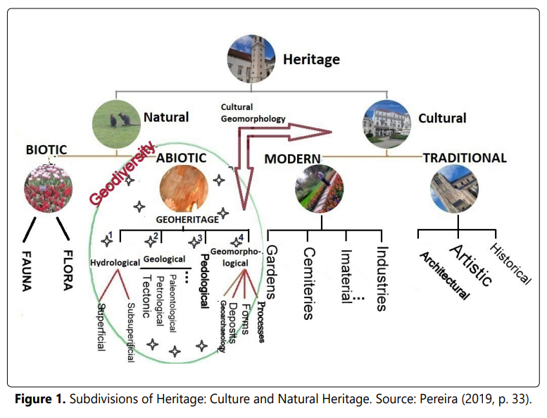
According to Figure 1, Natural Heritage can be subdivided into Biotic Heritage (fauna and flora) and Abiotic Heritage (or Geoheritage, which includes various heritage branches, among them Hydrological Heritage). It is from the concept of geodiversity that the physical elements of space can, or cannot, be elevated to the category of Geoheritage. Geodiversity can be defined, according to CPRM (2006, p. 4), as
[...] The study of abiotic nature (physical environment) consists of a variety of environments, composition, greological phenomena and processes that give rise to landscapes, rock, mineral, Waters, fóssil, soils, climate and other surface deposits that facilitate the development of life on Earth, with intrinsic values including cultural, aesthetic, economic, educational and tourist aspects” (CPRM, 2006, p. 4, free translation).
The term Geoheritage, as mentioned, is synonymous with Abiotic Natural Heritage. According to Rodrigues and Fonseca (2008), geoheritage corresponds to the set of values that portrays the Geodiversity of the territory and consists of a collection of natural abiotic elements located on the Earth’s surface, whether emerged or submerged, requiring preservation due to their heritage value. In other words, abiotic elements of nature should be preserved because they possess high economic, scientific, ecological, aesthetic, cultural, among other values.
Geoheritage includes Geological Heritage, Geomorphological Heritage, Hydrological Heritage, Pedological Heritage, and other mentioned elements (RODRIGUES and FONSECA, 2008).
The Tambiá Fountain, the object of analysis in this study, belongs to the hydrological heritage of João Pessoa. Hydrology is a comprehensive field of research and application of terrestrial phenomena where water plays a vital and broad-ranging role. In a broad sense, it aims to study three domains where water is present: atmospheric, oceanic, and terrestrial (LENCASTRE and FRANCO, 2010). However, the authors believe that it is more common to think of hydrology as the study of the occurrence, quantity, distribution, and circulation of water on the land, as well as its quality (physical and chemical properties) related to the environment and human use.
The Hydrological Heritage belongs to the abiotic portion of the Natural Heritage. In a very broad view, all elements of the physical environment are considered elements of natural heritage, including soils, rivers, seas, landforms, rocks, mineral and energy resources, plants and animals that, at least its scientific, economic, cultural and social significance, among others, deserve to be studied and preserved for future generations, that is, they deserve to be integrated into sustainable development strategies. Grandgirard (1997) bases the concept on cultural issues, essentially considering the scientific value, since the natural environment is a source of wealth, energy and resources for human beings, with its complexity, dynamics and sensitivity, that is, it is the heritage of society. All assets have the connotation of protected property or that, due to their characteristics and value, deserve protection.
In this work, it is proposed to subdivide Natural Heritage into Biotic, which includes the elements of fauna and flora that, due to their intrinsic value or because they are at risk of extinction, deserve to be protected, whatever ecosystem these forms of life are part of and; Abiotic, where the elements of geodiversity are inserted, such as water resources and their hydrosites, belonging to the Hydrological Heritage, in addition to the landforms, the geological elements and the soil, each with its sub-elements.
During the qualitative assessment phase (inventory), the values that elevate certain elements of geodiversity to the status of geoheritage stand out, values proposed by Sharples (1995) and Gray (2013). Thus, Geoheritage refers to those elements of geodiversity that have exceptional values (RODRIGUES and FONSECA, 2008) and, therefore, deserve to be preserved.
According to Sharples (op. cit.) and Gray (op. cit.), the main values are economic (associated with the needs of exploration by human beings, whether through mining, agriculture or civil construction, providing a patrimonial view on them, usually associated with soils, landforms and rocks. One can add subsurface and surface hydrical resources, necessary for life, both today and in the past, cultural (it concerns the value that the abiotic physical environment has for certain societies, due to its social or community significance), aesthetic (related to visual appeal, being an intangible concept of geodiversity, ranging from the scale of the outcrop or the isolated element to that of gigantic landscapes), ecological (geodiversity acts as a stage for the performance of human life and its activities and works, as a substrate for the support of the ecological system or as part of a geosystemic complex) and scientific (geodiversity is a laboratory, where the theoretical classes are put into practice, having a formal or informal educational power).
The first researches in the literature on Water Heritage, in this case the Hydrogeological Heritage emerged in the late 1990s, as an insertion in the so-called ‘geological heritage’, from studies by European geologists, with an emphasis on Spanish researchers and research on groundwater and its therapeutic qualities. In 1997, the mineral-medical values of groundwater allowed Coloma et al. (1997) call them Hydrogeological Heritage, as a consequence of their playful and contemplative potential, suggesting protection measures. Duran et al. (1998) defined the so-called ‘Places of Hydrogeological Interest’ that, despite being seen in a very broad perspective, by including “all places in which the water resource is of special interest” (emphasis added), this resource can be imagined in its most diverse forms (rivers, lakes, fountains, waterfalls, hot springs, etc.). In this way, the authors centralize the relationship between geology, geomorphology and water resources in the bias of the hydrological cycle.
Places of heritage interest in the water domain, which are representative for their condition of exclusivity and representativeness, scientific importance, for example as an paleoenvironmental indicator, ecological support, aesthetic value, among others, will be called ‘hydrosites’.
However, it must take into account the difficulty in separating the hydrological heritage, from the geological and geomorphological heritage (Cunha and Vieira, 2004), given the interrelationships between geology, geomorphology and hydrology. What does the value of a particular aquifer represent? The type of rocks, the morphology that they draw and that determines the circulation of the water or the quality of the water? A waterfall that, due to its spectacularity or scientific interest, deserves to have a patrimonial value and should be considered as geomorphological heritage (due to the differentiation of levels), geological (due to the lithological differentiation or the tectonics that imposes the unevenness) or hydrological (due to the amount of water involved)?
It is understood that this is where the term geoheritage acquires all its meaning, not only because it can agglutinate and geosystemically integrate the different elements of abiotic nature, but also because it can avoid procedural hierarchies in the functioning of the geosystem.
In geological literature, the view on hydrogeological heritage is restricted to fountains and thermal springs. For example, in the inventory of the hydrogeological heritage of the Geopark Naturtejo (Portugal), the nine sites of hydrogeological interest, arranged in geosites, are subdivided into three groups: thermal waters, cold mineral-medicinal waters and spring waters (RODRIGUES et al., 2011), although the Geopark has beautiful waterfalls, cannons and meandering rivers, which are included in the Geomorphological Heritage, they could also be included in the hydrological heritage.
Since the 2000s, the range of elements of nature inserted in the water heritage has expanded, going beyond the restricted concept of hydrogeological heritage, and paying attention to the spectacular forms (waterfalls, rapids, lakes), to the medicinal value of water (thermal waters), the ecological value (springs and particular locations of the hydrographic basins), its economic value (underground and surface water) and, of course, its scientific value, which justifies all the others and should always be the first value of the selection heritage, as follows.
The Zoobotanical Park Arruda Câmara is a zoobotanical garden located in João Pessoa, the capital of Paraíba, northeast Brazil. With an area of 26,8 hectares, the reserve has been designated as a historic and artistic heritage by the Institute of Historical and Artistic Heritage of the State of Paraiba (IPHAEP) since August 26, 1980. This ecological sanctuary was named Arruda Câmara Park in honor of a Paraiban botanist Dr. Manoel Arruda Câmara, on December 24, 1922. In the daily life of the city, the Tambiá Fountain is part of Paraiba’s history, revealling its symbolic and cultural aspects in the memory and local identity, evoking feelings and memories of the city’s inhabitants. From this, one can perceive the importance of the park for the city and the population of João Pessoa, wich lacks urban spaces that offer such a variety of resources, especially being a coastal city.
The objective of this work is to present an analysis of the Tambiá Fountain as a hydrosite, through the discussion of its values that have elevated it to the category of hydrological heritage, as well as the threats it is facing.
Material and Methods
To develop the current work, a methodological approach involving three steps was necessary, namely:
i) Literature review, aiming to provide direct access to everything written, spoken, or filmed about a specific topic. The topics in question are geoheritage, especially hydrological heritage, the physical aspects of the area such as geology and geomorphology, primarily, as well as historical information about Tambiá Fountain and the area in which it is located, Parque Arruda Câmara. The research was conducted using both primary and secondary sources, including books, doctoral theses, scientific articles, websites, and historical documents, especially those available at the Institute of Historical and Artistic Heritage of Paraíba (IPHAEP) and the National Institute of Historical and Artistic Heritage (IPHAN). The keywords used for searches were geoheritage, hydrological heritage, Tambiá Fountain, geology, geomorphology, and hydrology. The 15 most relevant articles for each term were analyzed, excluding those that did not meet the criteria. The criteria were to select only articles written in Portuguese that addressed the theme of the work or added to the concepts of the searches.
ii) Fieldwork, conducted on September, 2023, at Zoobotanical Park Arruda Câmara, located in the city of João Pessoa, PB, where Tambiá Fountain is situated. The purpose of this visit was to closely observe the condition of the fountain and photograph it to enhance the research with illustrations.
iii) Desk work: involved compiling the data gathered in the initial phases in the form of the present article.In this stage, a qualitative assessment was conducted through the completion of an inventory form that provides information about the hydrosite: framing (absolute and relative location and observation date), site description (access means, type of property, scale and synthesis of physical characteristics), importance (analysis of the most significant values - scientific, ecological, aesthetic, economic, and cultural, with the main criterion differentiating the property as either an element of geodiversity or elevated to the status of geopatrimonial property by possessing exceptionality in at least one of the values), and threats (analysis of anthropogenic and natural actions that make the hydro site vulnerable, suggesting measures to minimize or avoid them, as well as assessing the existing protection regime).
The Values of Geodiversity and the Tambiá Fountain
The municipality of João Pessoa is the capital of the state of Paraíba, the most eastern in Brazil. In fact, João Pessoa is known worldwide as the ‘eastern extreme of the Americas’, which in itself already has a potential for tourism. Its geographical coordinates are 7°7’S and 34°53’W (Figure 2), and the proximity to the Equator provides a lot of sunshine throughout the year and, therefore, high temperatures (annual average temperature of 26°C). The municipality has an area of 211.5 km2 and a population of 809,015 inhabitants (IBGE, 2019), resulting in a demographic density of 3825 inhabitants / km2, the highest in the state.
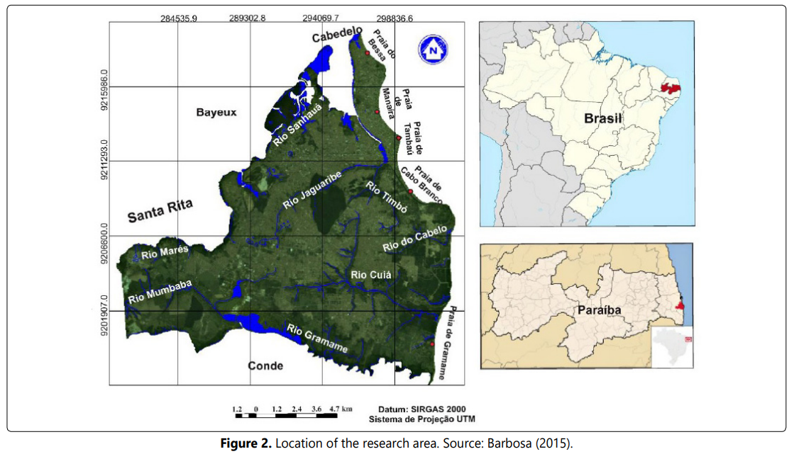
The Zoobotanical Park Arruda Câmara, popularly known as “Bica” due to its significant water potential, is located in the Alto Roger neighborhood, in the city center, with access possible from both Bandeirantes Avenue and Gouveia Nóbrega Avenue (Figure 3). Therefore, the location is well served by various bus lines. The fountain is situated in the southern quadrant of the park, right in front of the main entrance.

The fountains of fresh water are located in the Historic Center, being extremely important for their historical value, since they have supplied, for centuries, the population of the nascent city of Nossa Senhora das Neves, João Pessoa’s first name. After all, without drinking water, it was impossible to fix and develop an urban site and, in the case of João Pessoa, it was no different, as recorded in the historical documents. Thus, some springs in particular stand out in these documents and will be detailed, because of their history and culture, they constitute true hydrological heritage, configuring themselves in hydrosites. Tambiá Fountain is one of them.
For a long time, it served as a water supply point for a large population of João Pessoa. It holds great importance as it was highly effective for the residents, animals, and plants in the region, also contributing to the treatment of sick or injured animals due to human or non-human impacts.
Although it is a preservation area, it is also used for leisure and research. The park houses the remaining part of the Atlantic Forest and the famous “Tambiá Fountain,” a source of clean and potable water that was very useful for the city’s water supply at the time. The construction order was given on March 2, 1782, and it was named in honor of a legend, which will be presented later.
The term “Geodiversity” began to be used in the 1990s by geologists and geomorphologists with the aim of describing the variety of abiotic nature (Gray, 2004). Gray (2013) updates its definition, defining it as the natural variety (diversity) of geological elements (rocks, minerals, and fossils), geomorphological elements (landforms, topography, and physical processes), soil, and hydrological features. Understanding the importance of geodiversity beyond its economic value (Gray, 2004) allows for the development of mapping projects, conservation of geosites, identification work, and appreciation of the abiotic environment.
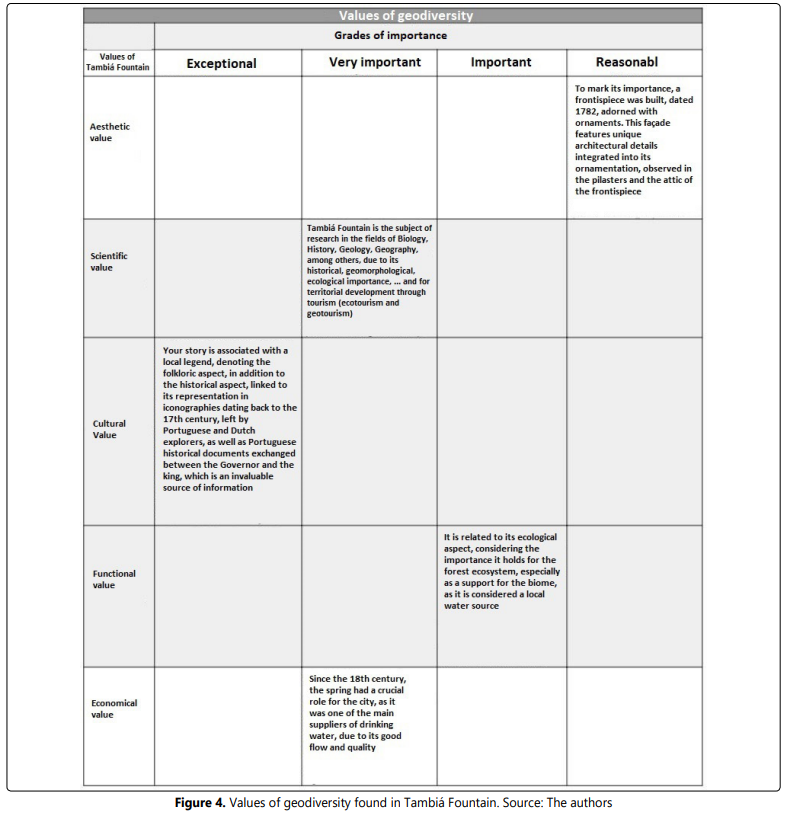
In his iconic work “Geodiversity - valuing and conserving abiotic nature” (Gray, 2004), six values (intrinsic, cultural, aesthetic, economic, functional, and research/educational) and 25 sub-values for abiotic elements of nature are proposed. Considering Tambiá Fountain, the subject of this study, not all of these values are present. Figure 4 presents the values that are present, along with their definitions, and, based on the fieldwork inventory, the level of importance of each value. This is crucial to understanding why this fountain can be considered an example of a hydrosite belonging to the hydrological heritage of the municipality of João Pessoa.
Aesthetic Value
The aesthetic value of Fonte Tambiá, considered to be of reasonable level, is represented by its facade that displays unique architectural details integrated into its ornamentation, observed in the pillars and in the pediment of the facade. As a landmark of its importance, a pediment was constructed, dating back to 1782, adorned with intricately carved ornaments in limestone.
According to Pereira (2019), the fountain contains two spouts, identified by the construction of a pediment. From an architectural perspective, this symmetrical pediment can be divided into two parts, with ashlar walls forming cushioned limestone panels with Baroque elements: an upper part, where informative plaques about its construction and renovations are located, featuring two conchoid volutes in S and C on the sides, separated by a shield without the imperial arms that were usually carved; and a lower part, also shaped like a shell but smaller in size (Figure 5).

It is important to emphasize that the various restorations undergone by the pediment may have obscured the original character of its design. Generally, a pediment consists of a set of four pillars, joined by two on each side. The pillars are strong enough to support the thrust and stone load of the pediment. Its facade has a classical composition of Late Baroque, resembling a frieze ending in an attic (IPHAN, 2014).
It is flanked by pistol-shaped shells, followed by two volutes of inverted accentuation leaves. In the center of the pediment, there are two plaques, one indicating the reconstruction of the fountain in the year of the Proclamation of the Republic (1889) and the name of the fountain. The other comes from restorations carried out during the time of Governor Solon de Lucena. The upper plaque, measuring 1.28m x 0.49m, appears on both sides of the horizontal end in pairs of connections (double S). The inscription reads: “Fonte do Tambiá, rebuilt in 1880 by the Governor of the Province, Dr. Gama-Roza.” The lower plaque, in turn, was built in 1922, measuring 0.65m x 0.36m, and is cast in bronze. It bears the following inscription: “The Tambiá Fountain was built in MDCCLXXII 1782, restored and improved during the term of the Honorary Doctor Solon Barbosa de Lucena, by Mayor Alfredo Guedes Pereira XCMXXII, 1922.”
According to historical records, Tambiá Fountain was built on March 2, 1782, using limestone, to serve the population. It is a cultural asset cherished by the citizens. However, for over a decade, it has been in a critical state of conservation due to a partial collapse of its ashlar stones. During fieldwork, it was observed that the fountain’s conservation is precarious, and there is a risk of it collapsing due to a lack of maintenance. Currently, it is supported only by wooden beams (Figure 5). The lack of maintenance results in the closure of the water passage to the lake inhabited by animals near the fountain, leading to the formation of a lake in front of the facade.
Scientific Value
Geodiversity is a learning environment where theories are applied, either formally or informally, in locations where natural processes can be directly observed, such as estuaries, coastlines, among others. In these places, geoscientists conduct research, examining landforms, deposits, and the evolution of landscapes. Furthermore, they also use traces that help understand the planet’s history, such as rock outcrops with their structural, textural, fossiliferous, mineralogical, and stratigraphic characteristics. Thus, according to Gray (2013), geodiversity can be valued for serving as an agent (‘service’) of knowledge and education. In this perspective, freshwater sources can also be included.
The Tambiá Fountain is the subject of research in various fields such as biology, history, geology, and geography, among others, due to its ecological, geological, and geomorphological significance, as well as its role in territorial development through tourism (ecotourism and geotourism). It has often been visited by researchers because it is in a precarious state, serving as a source of investigation due to the threat of collapse.
According to Araújo (2012), this spring originates from the Barreiras Formation, located about 7 meters above the Gramame limestone (Figure 6), at an approximate altitude of 19 meters. The author suggests that the northeastern portion of the Barreiras, where this spring originates, has a thicker limestone layer compared to the western slope, making it a source derived from the middle-upper portion of the Barreiras Aquifer.
Cultural Value
The cultural value pertains to the value that the physical environment holds for certain societies due to its social or communal significance (Gray, 2004). This encompasses geomythology or local legends and folklore, history/ archaeology, spirituality, and the sense of place.
In the case of Tambiá Fountain, throughout its history, many travelers, writers, geographers, and individuals of various nationalities have left a valuable legacy for the understanding of the world. This legacy consists, as follows, of iconographic representations and textual records in royal documents, constituting an invaluable source of information.
The origin of the name ‘Tambiá,’ for instance, is associated with a local legend, highlighting the folkloric aspect of its cultural value. The most well-known and widely disseminated legend in recent times is that of a young indigenous virgin named Aipré, from the Potiguara tribe, who fell in love with a warrior from her rival tribe, the Cariri tribe, named Tambía (RODRIGUEZ, 1962). After his death at the hands of his relatives, the young woman mourned over his grave for 50 moons, giving rise to a spring through her tears.
However, there is another legend that tells of a Tabajara Indian imploring Mother Earth for water so that her love, the Indian Tambiá, would not leave. On the day of his departure, the Indian is bitten by a centipede, promptly crushing the arthropod with force. As a result, Mother Earth is torn, and from two clefts spring forth the waters that gave rise to the Tambiá Fountain (MEDEIROS, 1994).
The Tambiá Fountain is also extremely important for its economic value, as it supplied the population of the emerging city of Nossa Senhora das Neves for several centuries, thus being crucial for the functioning of society.
In this context, Portuguese and Dutch iconographies from the 17th and 18th centuries related to João Pessoa (PB) hold significant importance for the historical and cultural study of the region. These visual representations provide valuable insights into the city during that period, allowing for a more detailed understanding of its evolution and transformations over time.
By studying and analyzing these iconographies, it is possible to gain a more comprehensive view of the history of João Pessoa and understand the influences and transformations that occurred during the 17th and 18th centuries. Additionally, these representations contribute to the preservation of the city’s historical memory and provide support for academic research, cultural tourism, and the appreciation of local heritage. In Vingboons’ iconography, dating back to 1640 (REIS, 2000), one can observe that the flora delineated across the territory is denser near bodies of water and settlements, referred to as ‘riparian forests’ (Figure 7). In these lower-lying areas, there were springs that supplied water to the primitive city.

In this iconography, the importance of Tambiá Fountain is understood, as its location is interconnected with the pathways that connected it to inhabited areas. This demonstrates the need to establish a direct and functional relationship between the water source and the city, allowing continuous and easy access to this vital resource. It is believed that selecting locations near springs and suitable for consumption is an important criterion for the establishment of urban nuclei.
The fountain represents one of the main monuments linked to the history of water supply in the city and had its peak importance for the local population between the mid18th century and the early 20th century when, during this period, the use of springs as the main water supply for the city decreased due to the implementation of the piped water supply system. Obviously, a change in water supply is, among other things, a habit-changing process that took some time for the community to adapt to; therefore, the water from the Tambiá reservoir was still widely used by the population until the mid-20th century (ARAÚJO, 2012).
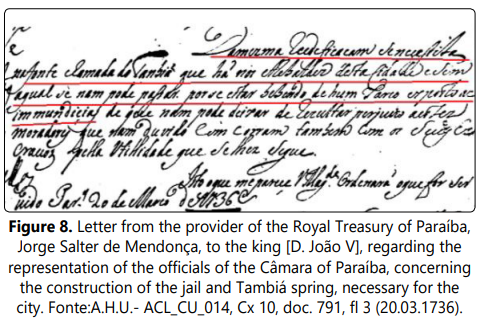
In historical documents about the fountain, there is a letter from Jorge Salter de Mendonça, the administrator of the Royal Estate of Paraíba, to King D. João V, dated March 20, 1736 (Figure 8). In this letter, he refers to the representation of the officials of the Câmara da Paraíba regarding the need for the reconstruction of the jail and the Tambiá Fountain in João Pessoa. The letter says: “From the same reconstruction, a spring called Tambiá, located in the outskirts of this city, is needed, without which one cannot endure, as people are drinking from a pond exposed to filth (free translation).”The essential importance of the fountain for the city is emphasized by stating “without which one cannot pass.” For this reason, he urgently requests the reconstruction of the fountain. It is worth noting that the fountain predates the pediment built in 1782, as mentioned earlier, and was already significant in the early 18th century.
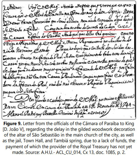
In another letter from the officials of the municipal council to King D. João V of Portugal, dated October 15, 1754, both parties complained that necessary works, such as the jail of the city of João Pessoa and the Tambiá Fountain, had not been carried out (Figure 9). The letter said: “Similarly, the repair works of the jail, Town Hall, and Tambiá spring are also necessary, any of them being equally crucial (free translation)”.
The activities undertaken by humans to protect and/or exploit geodiversity can be seen as cultural actions. These actions are considered cultural because they are carried out based on a specific worldview, the perception of roles played in society, and the development/assimilation of concepts and ideas, such as wealth generation, sustainability, development, and the environment.
Functional Value
The functional value, according to Gray (2004), is considered from two aspects: i) the in situ value of geodiversity, of a utilitarian nature for humans, meaning the appreciation of geodiversity that remains in its original place to facilitate various human activities (cities, dam construction, roads, etc.) or the storage of certain substances (groundwater, landfills, mounds, etc.); and ii) the value as a substrate for supporting physical and ecological systems; in other words, it refers to the population of animals and/or plants in locations where geodiversity has defined the ideal conditions for establishment and development.
In simpler terms, functional value plays a utilitarian role for society, serving as providers of substrates, habitats, and abiotic processes to sustain ecological and physical systems.
The functional value of fountain is related to its ecological aspect, considering the importance it holds for the forest ecosystem, especially as a support for the biome. Its functional value can also be considered as it serves as a water source for circular ecosystems. The water from the spring primarily functions to supply water to the enclosures of the Park’s animals, and consequently, to irrigate the large vegetation surrounding the spring.
This vegetation can be classified as Atlantic Forest. The Atlantic Forest is the generic name for a variety of humid tropical forests that occur in the coastal regions of Brazil, following the moisture brought by the southeast trade winds. For example, it includes lowland ombrophilous forest, or open forest when associated with river channels and on the top of coastal plateaus (as is the case with the mentioned forest); or moist broadleaf hillside forest, especially on the slopes of the Serra do Mar in the Southeast, which houses one of the highest degrees of species richness and endemism rates on the planet (ANDRADE LIMA and ROCHA, 1971).yp At the time of discovery, this vegetation formation extended over an area of 1.3 million square kilometers, of which currently no more than 4% of primary remnants remain in a medium stage of regeneration (BRASIL, 2004). In the area, it corresponds to a vegetation cover with an essentially arboreal stratum, featuring trees reaching between 25 to 30 meters in height, broad canopies, thick trunks, dense and rich in biodiversity, with the presence of epiphytes, evergreen, broad-leaved, hygrophilous, and locally with a relatively dense shrub and herbaceous stratum. In the coastal plateaus, this vegetation has practically disappeared with the advance of urbanization, leaving some preserved patches around certain river courses, in the so-called ‘grottoes.’ Standout species in these areas include bulandi (Symphonia globulifera), jatobá (Hymenaea courbaril), pasta (Pistia sp), sapucaia (Lecyhis pisonis), embiriba (Eschweira ovata), pau-brasil (Caesalpinia echinata), sucupira (Bowdichia virgilioides), massaranduba (Manilkara huberi), pau-d’arco roxo (Tabebuia impetiginosa), and amarelo (Tabebuia chrysotricha), among others (ARAÚJO, 1993).
Economic Value
The economic value of geodiversity arises from the need for human exploitation, which can come from agriculture (soil), mining (rocks), construction (rocks and sediments), as well as water resources, both underground and surface, providing a heritage perspective on them.
According to Pereira (2006, p. 72), the economic value of geodiversity relates to “[...] the potential for various tourist and sports activities.” In other words, humans extract and utilize minerals and rocks, estimating figures and driving both local and global economies. On the other hand, this value is justified by the need to quantify a financial value for an aspect or resource of the natural diversity of the environment (BRILHA 2005; GRAY, 2004).
Since the 18th century, Tambiá Fountain played a crucial role for the city as one of the main sources of potable water for the population due to its good flow and quality. However, in response to the increasing demand for water supply, there arose a growing concern regarding the conservation of the surrounding environment, with a particular emphasis on preserving forested areas. Various interventions were carried out to maintain its structure, as referenced in historical documents dating back to the 18th century (Figures 8 and 9), which highlight the care that local leaders had for the preservation of the spring and its vicinity.
The provision of water persisted until the implementation and establishment of the piped water distribution system in the city, a process that extended for approximately two decades from 1890 (NOGUEIRA e SOUZA, 2005). However, unlike other sources, it managed to maintain its historical significance as a notable vestige of the city’s water supply, thus contributing to its significant economic value.
Conclusions
Water, as an important element of geodiversity, is the result of the action of a set of endogenous and exogenous factors. At the moment when human beings value places of hydrological interest, these hydrosites have heritage value and deserve to be safeguarded for future generations, which corresponds to one of the principles of geoconservation.
The inventory consists of the first step in the survey of geodiversity, its geoheritage and, specifically, hydrosites that represent its history from the physical point of view, being the basis for the purpose that is desired, whether for the development of geotourism activities, educational purposes or for geoconservation.
From previous studies about the geomorphology and geology of the area, the history of the city and other pre-established criteria, such as scientific, cultural, ecological, economic and aesthetic value, the Tambiá Fountain was inventoried and, elevated to the status of geoheritage due to the very high cultural value and high economic and ecological (functional) value.
Historical documents, such as the letters sent to King D. João V in 1736, emphasize the indispensability of Fonte Tambiá for the city. Visual representations of the spring in historical iconography highlight its connection to urban areas, underscoring the importance of choosing locations near water sources for the establishment of urban centers. The origin of the name “Tambiá” is wrapped in a local legend, adding a folklore touch to its cultural significance. In summary, Fonte Tambiá stands as a cultural and historical landmark of João Pessoa, playing a crucial role in its evolution and identity. Moreover, its economic value is notable, having provided water to the city from the 17th to the 20th centuries.
However, its current state of conservation demonstrates a lack of sensitivity on the part of public authorities, even though the spring has been listed as a protected site since 1980, which should have required protective measures to be implemented.
The present work aimed to promote the hydrological heritage of the municipality of João Pessoa through the inventory and assessment of Fonte Tambiá, an example of a local hydrosite. The goal is to raise awareness for the adoption of geoconservation measures and to disseminate Geosciences, sharing scientific knowledge—a cornerstone of geoeducation and the study of geodiversity.
References
